Download
1 / 25
250 likes | 580 Vues
Location and size. Iceland lies close to the Arctic Circle. Total area:103,000 square km. Iceland is geologically a young country, and is still in the process of formation. The interior: plateaus and mountains.

E N D
Location and size Iceland lies close to the Arctic Circle. Total area:103,000 square km. Iceland is geologically a young country, and is still in the process of formation. The interior: plateaus and mountains. The highest mountain: Hvannadalshnúkur in Öræfajökull glacier (glose to Skaftafell), about 2110 m.
Flora The Icelandic flora includes about 470 species of indigenous and naturalized species of vascular plants. Common species of trees: Sorbus aucuparia L. (Reynir) Betula pubescens (Birki) Juniperus communis (Einir) Pinus mugo (Fjallafura) Larix sibirica Ledeb (Lerki) Picea engelmannii (Blágreni)
Fauna When Iceland was settled in the ninth century, the Arctic fox was the only land mammal in the country. Later, man introduced (accidentally!) the mouse and the rat, and still later deer and mink were imported. The mink was imported for fur farming, but some animals escaped and the mink now belongs to the fauna of the island. Sea mammals: Seals and whales. Birds: More than 200 kinds; 72 nest regularly. Fresh Water Fishes:Salmon and trout.
Hot water is used for electricity production and heating spaces (homes, greenhouses..), swimming pools, pavements etc.
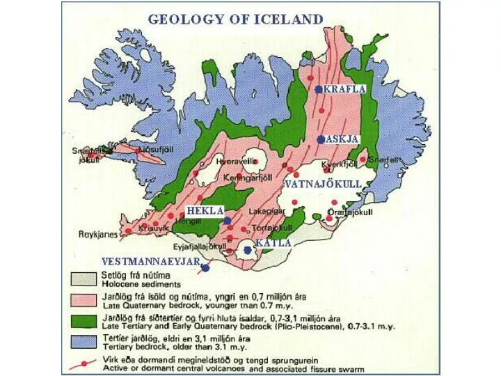
Continental drift Iceland is on the Mid-Atlantic Ridge, where the Eurasian and North American crustal plates are formed by volcanic activity. The youngest rocks appear in the middle Ca 10% of Iceland is covered by glaciers
Geothermal water Cold and hot ground water Hot and cold ground water Magma body
Svartsengi and The Blue Lagoon • The Svartsengi geothermal power plant is connected to boreholes producing steam and a mixture of steam and water • There are heat-exchangers that produce hot water and urbines that generate electricity • The Blue lagoon was formed when hot water from the nearby Svartsengi geothermal power plant that formed due to heat exchange was discharged into the adjacent lava field
The Journey http://www.casdn.neu.edu/~geology/department/staff/colgan/iceland/iceland.html
Þingvellir At Þingvellir, Alþing - general assembly was established A.D. 930 and continued to convene there until 1798. Many major events in the history of Iceland have taken place at Þingvellir. Today Þingvellir is a national park The faults and fissures of the area make evident the rifting of the earth's crust
Gullfoss and Geysir Gullfoss (The Golden Waterfall) is in River Hvítá which has its source underneath the glacier Langjökull, and flows into the Atlantic. The water cascades down 33 m into the 2,5 km long canyon below. The canyon was created at the end of the last glacial period flood waves. Following large earthquakes in Souhtern Iceland in June 2000 Geysir started to erupt after having been dormant since 1915. The geyser Strokkur erupts every 8 minutes and has been the main geysir in the area since 1963.
Until the last glacial age a continuous glacial cap covered the highland area and the ocean extended far inland in the lowlands of South Iceland
Skógar og Vík í Mýrdal Skogar: two farms, a school and a folk museum. Old houses have been restored and rebuilt on the museum grounds. The church is a replica of old country churches; the inside decorations are old artefacts from bygone churches. Vík í Mýrdal: the southernmost coastal village of the country. There arelarge bird breeding colonies not far from the village: arctic tern (kría), puffins (lundi), guillemot (langvía), fulmar (fýll), kittiwakes (rita) etc.
Katla Photograph of Katla volcano erupting through Mýrdalsjökull ice cap in 1918. This eruption deposited a huge volume of tephra on the ice cap and surrounding landscape, and unleashed a catastrophic flood of melt water and sediment over Mýrdalssandur Katla volcano is showing signs of unrest
Kirkjubæjarklaustur In 1186 a convent of the Benedictine order was established but in1550, the Icelanders were became lutherian. Topographical names in the area remind of the catholic past, such as Systrastapi. Two nuns are said to have been buried there after they were burned at the stake.This area contains some famous natural phenomena.
Skaftáreldar The Skaftáreldar eruptions of 1783. A long row of craters erupted for almost two years and covered the area with lava and the whole country with ashes. Pastures were poisoned and people and livestock died of famine and diseases. Only 38.500 Icelanders survived the disaster. The Danish authorities contemplated to move the surviving population to Denmark
Skaftafell The national park Skaftafell contains precious natural pearls: glaciers and mountains. It includes half of Glacier Vatnajokull. There are no roads for motorized vehicles in the park, but there is a network oftrails.
Öræfajökull Oraefajokull is the largest active post-glacial volcano in Iceland. Oraefajokull is also nown for its outlet glaciers that sweep down into the surrounding lowland plains from the volcano. North and north-west of Oraefajokull is the largest glacier in Iceland, Vatnajokull. Oraefajokull has erupted twice in historical times: in 1362 and 1727. The 1362 eruption was explosive and the largest in Icelandic historical time. It destroyed a whole district with floods and tephra fall. By the 1400's a new settlement had sprung up again in this area.In 1727 Oraefajokull erupted again, and with similar effects.
Jokulsárlón Jokulsarlon (glacier lagoon), east of Skaftafell, is a deep lake clustered with ice floes
The origins of Icelanders Analysis on the Y-chromosome and mtDNA indicate that about 80% of Icelandic men and 40% Icelandic women are of Scandinavian origin
The Origins of the IcelandersSigurður Nordal InstituteÞingholtsstræti 29P.O. Box 1220, 121 Reykjavík, IcelandTelephone: 562 6050, fax: 562 6263, nordals@hi.is The Viking Age (800-1066) is the most famous period of Scandinavian history. At that time, the Norse seafarers took control of all the sea passages around northern and western Europe, as well the water trade routes in the east and southwards to Russia. They even went as far south as the Mediterranean Sea. On their voyages around the oceans, they discovered and settled uninhabited islands, among them Iceland, the Faroe Islands and Greenland.Norse OriginsIn The Book of the Icelanders (Íslendingabók), the first Icelandic historian, Ari Þorgilsson the Wise (1068-1148), relates the following:Iceland was first settled out of Norway […] at the time […] when Ivar Ragnarsson Shaggy Breek killed the English King Edmund the Holy. That was seventy winters into the nine hundredth year after the birth of Christ, as described in his saga. There was a Norseman called Ingólfr, who can truly be said to have first travelled to Iceland when Haraldr the Fairhaired was sixteen winters old and a second time a few winters later. He settled in the south, in Reykjavík. (the Icelandic version of Íslendingabók which can be found in Volume 1 of the Íslenzk Fornrit series, this excerpt on pages 4-5.)
The Origins of the IcelandersSigurður Nordal InstituteÞingholtsstræti 29P.O. Box 1220, 121 Reykjavík, IcelandTelephone: 562 6050, fax: 562 6263, nordals@hi.is There are reports of seafarers who came to the island before Ingólfur’s voyage and who stayed there over the winter. One of these was Floki Vilgerðarson, also known as “Hrafna” or Raven-Floki. He was a Norwegian viking who used the raven as his sailing guide, on account of which he acquired his nickname. He had intended to settle in Iceland but returned to Norway after a difficult winter. It was Hrafna-Floki who gave Iceland its name. According to The Book of Settlements (Landnámabók), Ingólfur Arnarson established himself in Iceland in 874. However, it is the Irish monks who are thought to have been the first men to settle the country in the eighth and ninth centuries, although there are few remains or remnants of their settlement. Most indications are that the majority of settlers came from Norway, but there is also talk of the mixing of Norse and Celtic blood when the Norsemen went on Viking raids. Placenames throughout the country bear witness to the Norse origins of the Icelandic people, and some places are named after the Norse gods, such as Þórshöfn (Thor’s harbour) and Þórsmörk (Thor’s pasture), while other place names point to the nation’s Celtic origins, for instance Bekansstaðir (Beecan’s place), Njálsstaðir (Nial’s place) and Írafell (Mount Irish).
The Origins of the IcelandersSigurður Nordal InstituteÞingholtsstræti 29P.O. Box 1220, 121 Reykjavík, IcelandTelephone: 562 6050, fax: 562 6263, nordals@hi.is IIIGenetic Research into Icelandic OriginsNot everyone is as convinced of the supposed Norse origins of the Icelandic people, and some believe that recent research into the genetics of men on the one hand and women on the other lends support to their doubts. The research has concentrated on genetic mitochondria which are inherited in the female line alone, from mother to child. Since almost all of the inherited genetic mitochondrion of Icelanders has been passed directly from women of the settlement period, it is possible through comparative research to work out their origins. The first results to come out of the research, which is being done by DeCode in collaboration with the University of Oxford, indicate that 63% of Icelandic female settlers were of Celtic origin and had ancestral lines traceable to the British Isles. On the other hand, only about 37% of them were of Nordic origins. However, the research into male Y-chromosomes (inherited via the male line) revealed that a much greater percentage of male settlers were of Nordic origins, or 80%, and 20% have origins which can be traced to the British Isles. This is one of the most extensive genetic research projects ever conducted in one country in order to investigate its origins, but conclusive results are not yet ready.