Download
1 / 10
100 likes | 535 Vues
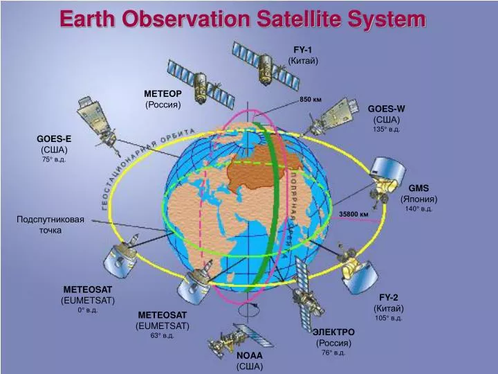
Earth Observation Satellite System FY-1 ( Китай) МЕТЕОР ( Россия) 850 км GOES-W ( США) 13 5° в.д. GOES-E ( США) 75° в.д. GMS ( Япония) 140° в.д. 35800 км Подспутниковая точка METEOSAT (EUMETSAT ) 0 ° в.д. FY- 2 ( Китай) 105° в.д. METEOSAT (EUMETSAT ) 63 ° в.д. ЭЛЕКТРО

E N D
Earth Observation Satellite System FY-1 (Китай) МЕТЕОР (Россия) 850 км GOES-W (США) 135° в.д. GOES-E (США) 75° в.д. GMS (Япония) 140° в.д. 35800 км Подспутниковая точка METEOSAT (EUMETSAT) 0° в.д. FY-2 (Китай) 105° в.д. METEOSAT (EUMETSAT) 63° в.д. ЭЛЕКТРО (Россия) 76° в.д. NOAA (США)
RUSSIAN HYDROMETEOROLOGICAL SATELLITE SYSTEM 850 км METEOR №3 Oceanographical METEOR №2 ГЕОСТАЦИОНАРНАЯ ОРБИТА 35600 км ПОЛЯРНАЯ ОРБИТА ELECTRO №2 (14° E.) ELECTRO №1 (76° E.) METEOR №1
Russian Earth Observation Satellites Program 2006-2015 2006 2007 2008 2009 2010 2011 2012 2013 2014 2015 2016 2017 2018 2019 2020 ELECTRO № 1 (76°E) ELECTRO № 2 (location TBD) Geostationary meteorological system ELECTRO № 3 (76°E) METEOR № 1 METEOR № 2 METEOR № 3 (Oceanographical ) Polar-orbiting meteorological system METEOR № 4 METEOR № 5 METEOR № 6 (Oceanographical) KANOPUS-V № 1 KANOPUS-V № 2 R&D environmental satellites RESURS-P № 1 RESURS-P № 2
ELECTRO-L General Design •Three-axis high-precision stabilization • In-orbit mass - 1500 kg • Payload mass-370kg • Lifetime - 10 years • Longitude - 76E • Data dissemination format - HRIT/LRIT • Image repeat cycle – 30/15 min Mission objectives • Operational observation of the atmosphere and the Earth surface (MSU-GS) • Heliogeophysical measurements • Maintaining Data Collection System and COSPAS/SARSAT Service
MSU-GSBasic Performance Characteristics 1. Number of channels VIS IR 10 3 7 2. Spectral range at half maximum of spectral response function (m) 0.5-0.65; 0.65-0.80;0.8-0.9; 3.5-4.0; 5.7-7.0; 7.5-8.5;8.2-9.2; 9.2-10.2; 10.2-11.2; 11.2-12.5 3. Image frame (deg x deg) 20 0.5 x 20 0.5 4. HRIT ground resolution in subsatellite point (km) 1.0 (VIS); 4.0 (IR) 5. S/N ratio for VIS channels 200 6. NET at 300K (K) in the band 3.5-4.0 m in the band 5.7-7.0 m in the band 7.5-12.5 m 0.8 0.4 0.1-0.2 7. Power (W) 150 8. Weight (kg) 88 9. Lifetime of basic and reserve units (years) 10
METEOR-M General Design • In-orbit mass –2700 kg • Payload mass–1200 kg • Lifetime – 5 years • Orbit – Sunsynchronous • Altitude – 830 km • Data dissemination format – HRPT/LRPT
Application Spectral Band Swath-width (km) Resolution (km) MSU-MR Global and regional cloud cover mapping, SST, LST, … 0.5 – 12.5 m (6 channels) 3000 1 x 1 KMSS multichannel scanning unit Earth surface monitoring 0.4-0.9 m (3 channels) 100 0.06/0.1 MTVZA imager/ sounder Atmospheric temperature and humidity profiles, sea surface wind 10.6-183.3 GHz (26 channels) 2600 12 – 75 IRFS-2 advanced IR sounder * Atmospheric temperature and humidity profiles 5-15 m 2000 35 Severjanin (SAR) Ice monitoring 9500-9700 MHz 450 0.4 x 0.5 Radiomet* (radio occulation unit) Atmospheric temperature and pressure profiles. METEOR-M Mission Objectives and BasicInstruments Instrument * - to be launched on board METEOR-M №2
RESURS-DK General Design • In-orbit mass -6570kg • Payload mass-1200 kg • Lifetime - 3 years • Orbit – elliptical, H=360-604 km • Inclination – 70,4° • Launched 15.06.2006 RESURS-DK Instruments Payload Swath Width - 28,3 / 448 km Spectral Bands - 0,58-0,8; 0,45-0,5; 0,55-0,59; 0,65-0,68; 0,72-0,75; 0,75-0,78; 0,78-0,9; 0,9-1,1 m Resolution panchromatic system - 1 m multi spectral system - 2-3 m
Roshydromet Satellite Ground Segment 3 Main centers: Europe (Moscow-Obninsk-Dolgoprudny) Siberia (Novosibirsk) Far-East (Khabarovsk) - 68 Local centers
0,4 ГГц 8,2 ГГц 0,4 ГГц 1,7 ГГц 1,7 ГГц 1,7 ГГц 1,7 ГГц 7,5 ГГц 1,7 ГГц 137 МГц 8,2 МГц 8,2 МГц 137 МГц Status of Roshydromet Ground Segment ОРГАНИЗАЦИИ РОСГИДРОМЕТА Гидрометцентр РФ, ГОИН, ААНИИ,ЦАО, ИПГ, ГВЦ, ГРМЦ, ГГИ, ГХИ,ВНИИГМИ-МЦД, ИГКЭ и др., УГМС (ЦЧО, Верхне-Волжское, Северо-Кавказское,Западно-Сибирское, Дальневосточное др.) ГУ НИЦ «Планета» (Москва, Обнинск, Долгопрудный) Метеорологические геостационарные КА Метеор Terra, Aqua Электро Метеор MTSAT ЭлектроMeteosat/ GOES/MTSAT ОРГАНИЗАЦИИ ВЕДОМСТВ МО РФ, МЧС, МПР, РАН, Минтранс, Минтопэнерго, Роскосмос и др. потребители г. Обнинск СПОИ 1.7ГГц 665,4Кбит/с Ливень-П 7,5/8,2 ГГц 2,56 Мбит/с ТНА-57Р + ПРИ-П 8025-8400 МГц 61,44 Мбит/с РЕГИОНАЛЬНЫЕ ПОТРЕБИТЕЛИ Федеральные округа: Центральный, Приволжский, Южный, Северо-западный, Уральский, Сибирский, Дальневосточный. Администрации городов и областей: г. Москва, г.Нижний Новгород, Московская обл., Оренбургская обл., Вологодская обл., Архангельская обл., Тверская обл., Ростовская обл. и др. РРЛ 2,0 Мбит/с Meteosat/ GOES/MTSAT NOAA Метеор Электро NOAA Метеорологческие полярно-орбитальные КА СIR 1,7 ГГц 665 Кбит/с Селена 7,5 ГГц 2,56 Мбит/с Сканэкс 1,7 ГГц 665 Кбит/с г. Москва 11 ГГц DVB ЗАРУБЕЖНЫЕ ПАРТНЕРЫ Страны СНГ и Балтии, WMO, EUMETSAT, CGMS, CNES, ESA, NASA, DLR, NASDA, НКАУ и др. Электро Meteosat/ GOES/MTSAT EOS/Terra,Aqua Метеор NOAA Terra, Aqua Метеор Meteosat Комплекс обработки, архивирования и распространения данных Комплекс планирования работы БИК и НКПОР г. Долгопрудный ПК-7 1.7ГГц ПК 3,5 8,2 ГГц 15,36 Мбит/с ALFA 1,7 ГГц 166 кбит/с РРЛ 6,0 Мбит/с Супер ЭВМ (ГидрометцентрРФ) Сеть ПСД Сеть АППИ ЗС РЦПОД (Новосибирск) ДВ РЦПОД ( Хабаровск) ЗС РЦПОД АППИ ДВ РЦПОД Электро Метеор NOAA Terra Aqua Terra Aqua Метеор NOAA Метеор NOAA NOAA NOAA Метеор Meteosat Обмен управленческой информацией по выделенным каналам Сканэкс (11ст.) 1,7 ГГц ... Терминал-ГМ (20 ст.) 0,4 ГГц 100 бит/с ОРГАНИЗАЦИИ УПРАВЛЕНИЯ КА ЦУП-О и БЦ (Краснознаменск), ЦУП (Рокот), ЦУП-М (ЦНИИМаш), БЦ (ЦНИИМаш), ГНПП “Орбита” (Украина), ЦКН (Роскосмос) и др. АППИ (45 ст.) 137 МГц Сканэкс 1,7 ГГц 665 Кбит/с УППОИ 1,7/8 ГГц 0,665/15,36 Мбит/с ЕОСкан 8 ГГц 15,36 Мбит/с Сканэкс 1,7 ГГц 665 Кбит/с СПОИ 1,7ГГц 665,4Кбит/с Ливень-П 7,5/8,2 ГГц 2,56 Мбит/с ТНА-57Р + ПРИ-П 8,2 ГГц 61,44 Мбит/с НИЦ Планета – методическое руководство и управление НИЦ Планета – методическое руководство и управление Комплекс обработки Комплекс обработки