Download
1 / 5
0 likes | 6 Vues
Mapping drones in Saudi Arabia are becoming increasingly popular in the region, as they offer a number of advantages over traditional surveying methods. Drones can collect data quickly and efficiently, and they can access areas that would be difficult or dangerous for humans to reach. This makes them ideal for a variety of applications.

E N D
Mapping drones in Saudi Arabia are becoming increasingly popular in the region, as they offer a number of advantages over traditional surveying methods. Drones can collect data quickly and efficiently, and they can access areas that would be difficult or dangerous for humans to reach. This makes them ideal for a variety of applications, including: Customized Drones™– Key Applications of Mapping Drones in Saudi Arabia
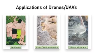
Construction Mapping In Civil Engineering field mapping drones are used for site surveys, progress monitoring, and as-built documentation. Mining Mining is an industry that having often unexpected situations. To avoid such situations and ensure the safety, mapping drones are used for surveying and monitoring mine sites, estimating stockpile volumes..etc Search and Rescue In emergency situations, drones equipped with thermal cameras and GPS can be used for search and rescue operations. Customized Drones™– Key Applications of Mapping Drones in Saudi Arabia
Infrastructure Inspection Mapping drones are used to inspect infrastructure such as bridges & power lines to detect damage or potential issues, especially in solar panel inspection. Mostly thermal cameras are used to investigate these issues and ensure safety. Agriculture Farmers and agricultural institutes are used mapping drones to monitor crop health, finding the drainage facilities, create prescription maps. For these services both LiDAR and Thermal camera are used. Customized Drones™– Key Applications of Mapping Drones in Saudi Arabia
Contact Customized Drones™ for more information Location: Maktoum Road, Golden Business Centre, Offices 203-204 – Dubai UAE Email: info@c-drones.com Website: https://c-drones.com/shop/uav-mapping-drones/ Contact : +971 4 295 8013