Download
1 / 25
260 likes | 1.17k Vues
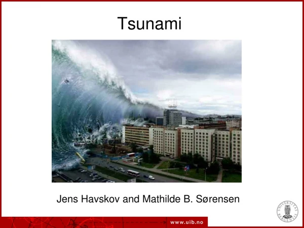
SUSTAINABLE URBAN DESIGN CONCEPT FOR TSUNAMI RISK AREA CASE STUDY : TOWN IN THE SOUTHWEST COAST ACEH REGION. BY : Nurlisa Ginting and Achmad Delianur Nasution. Sustainable Development.

E N D
SUSTAINABLE URBAN DESIGN CONCEPT FOR TSUNAMI RISK AREA CASE STUDY : TOWN IN THE SOUTHWEST COAST ACEH REGION BY : Nurlisa Ginting and Achmad Delianur Nasution
Sustainable Development “Sustainable development is development that meets the needs of the present without jeopardizing the ability of future generation to meet their own needs” World Comission on Environmental and Development (Brundtland Comission, 1987).
Sustainable Urban Design Nine principle for “sustainable society” : • Respect and care for community of life • Improve the quality of human life • Conserve the Earth’s vitality and diversity • Minimize depletion on renewable resources • Keep within the Earth’s carrying capacity • Change personal attitudes and practices • Enable communities to care for their own environments • Provide an international framework for integrating development and coservation • Create global alliance
Objective of Urban Design The purpose of Urban Design (Spreiregen 1985) : • To make the extend of the city comprehensible • To make the city human • To relate urban forms to natural settings • To weave new centers into the urban fabric • To complement the monumental with the mundane • To complement the urban with nature • To create key focal sites • To make the city a harbor of Diversity
Tsunami :Guiding and Preventing Principles • Recognize the risk of tsunami • Avoid new development in the affected areas to reduce the future victims • Arrange new development in the affected areas and minimizing the loss of damage in the future. • Plan and build the new building in reducing the damaged. • Protect developed areas from the Tsunami affected with the reconstruction, redesign and reoccupied. • Special prevention needed in arranging and redesign of the infrastructure and public facility to reduce the damaged. • Evacuation Planned
Natural Dimension of Urban Design McHarg (1989), Lewis, and other eloquent exponents of the environment planning movement have brought into focus the evolving philosophy that ecological processes provide indispensable basis for planning and design. The dependence of one life process on another; the interconnected development of living and physical process of earth, climate, water, plants, and animals; the continuous transformation and recycling of living and non-living materials; these are the elements of the self-perpetuating biosphere that sustain life on earth and which give rise to the physical landscape. They become the central determinants of form for all human activities on the land. The “Form Follow Function” principle could not be the sole basis for environmental design. Today, “Design with Nature” principle is part of design practices which is more appropriate to the evolvement process of nature.
Industry Open Space Open Space Buisness District Housing Mosque School Open Space Open Space Human Dimension of Urban Designin Tsunami Risk Area The concept of modern lifestyle which is based on moral code of Islam, is one among concepts mentioned by Prof. Ghani Salleh from University Sains Malaysia in the “Urban Recovery After Earthquake and Tsunami Disaster” seminar on January 29, 2005 which was organized by Architecture Program of Postgraduate School of University of North Sumatera.
Physical Dimension of Urban Designin Tsunami Risk Area City Shape A number of City Shape Concepts for areas which is in jeopardy of tsunami: - Redeveloping new town in the area of low possibility to be hit by tsunami wave, for example: in remote areas from sea coast, in highland areas , or in wall-surrounded areas. • Creating natural barrier to tsunami waves that physically could be mangrove trees or strong plants. • Applying Compact city shape by an intensive and high integrated land use which could also prevent natural destruction extensively, at once.
Physical Dimension of Urban Design in Tsunami Risk Area Urban Element Land Use At the macro level, land use in sea coast area suggested to be the coastal boundary line (300-500 m), which is used to be the green area and natural drainage area so it could be the buffer or protection against tsunami wave. According to the field work in the west coast of Aceh, the destruction effects of tsunami wave generally lessened in the distance of 250 meters from the sea coast. Vehicles Circulation The perpendicular major circulation from coastal area towards the hill is designed wide open and leads directly to the evacuation point to assist community to evacuate when tsunami comes.
Physical Dimension of Urban Design in Tsunami Risk Area Pedestrian Ways The shape of compact city creates possibilities to plan transportation mode that prioritize the pedestrian, hence, the use of un-renewable fossil fuels such as gasoline, could be reduced as minimum as possible. Furthermore, the pedestrian patterns could be able to generate socialized lifestyle in urban community. Building Form and Massing The orientation of building would be better to face the sea or able to receive quick warning of vulnerabilities from the sea. Building construction should be focused on earthquake resistance structures or temporarily withstand during the people try to find more secure place. Open Space Open spaces, squares and mosque courtyards turned to be evacuation areas in emergency situation.
Physical Dimension of Urban Design in Tsunami Risk Area Activity Support Fishery and its activity supports are part of community livelihood and in principal, the location has to be remained in the coastal area to support the community to run their daily activities. Information Information, as part of community facilities, is set at public places and coastal areas. Preservation The persistent buildings after the tsunami, especially public buildings could be reoccupied as long as the construction strength remains structurally accepted. This would be memorial buildings and have economic advantage.
Survey of Towns in the Southwest Coast Aceh Region • Survey was managed by a voluntary architects team from Architecture Department of Postgraduate Program of North Sumatera University and Indonesian Institute of Architects (IAI) in collaboration with Emergency Architect, Perancis. • The survey was conducted on January 20– 26, 2005; covering towns and villages in coastal districts along southwest coast of Aceh regions between Meulaboh and Blang Pidie towns.
Survey of Towns in the Southwest Coast Aceh Region • The Regencies of West Aceh, Nagan Raya andSouthwest Aceh. • The Regency towns: (1)Kuala (2)Manggeng (3)Tangan-tangan (4)Susoh (5)Keuda Batee (6)Johan Pahlawan (7)Merbau (8)Samatiga (9)Arongan Lambalek (10) Darul Makmur
THE TYPOLOGY OF TOWNS AND SETTLEMENTS OF SOUTHWEST ACEH REGION BEFORE THE DISASTER • Ribbon shape city • It was shaped by the ‘barriers’: coastal zone on one hand, and hilly land on the other. • The growth of town follows the linier pattern of road. • The orientation of physical formation of town is roads. • The towns are back on to the sea.
THE ARCHITECTURE TYPOLOGY OF TOWNS IN SOUTHWEST ACEH REGION • A neighborhood pathway in each of every two (2) housing lots which is more-or-less parallel to the coastal line. • Pathways between settlements which oriented to sea and to the road. • With an interval of three-blocks-of-housing, there is an artery road which its position is also functioned as the boundary between flat ground and hill.
Site Section of Town / Settlements of Aceh West Coast • At the coastal boundary line which is the government property (about 150 m coastal line), settlements orientation is to the sea in a dispersive pattern. the spread. • There are also a number of Fishermen Activity Centres at this boundary line. • At the back of this boundary line there is a linier pattern settlement oriented to the road.
Neighbourhood pathway in settlement area and the typology of Architecture
The Architecture typology of towns in Southwest Aceh Region ROAD Settlement Housing orientation is to the pathway not to the sea. Dominant housing spacious, more-or-less 30m2 Single-floor houses. Materials are mainly wood and cement plaster. TO THE SEA
Survey of Towns in the Southwest Coast Aceh Region By many variations in different locations, the totally destroyed buildings is in the distance of 250 metersfrom the coastal line. The condition of town around Meulaboh Mosque
Survey of Towns in the Southwest Coast Aceh Region Buildings in the coastal boundary line are oriented to the road and backed on to the sea.
Land Use Design Concept Land Use Pattern Land use planning for coastal towns regions aftermath of the earthquake and tsunami disaster is based on the estimation of building location and activities safeness to the tsunami hazard, as follows: • The seaport and wave-breaker planned to be built at the seashore areas which is directly contact to the sea. • The area within the coastal boundary line and the edge of the road is planned a greenery area consists of vegetations to absorb and resist wave energy. This area could also become a public open space. • The artery road is planned in the boundary between coastal and hilly zones. • Settlement is placed in the hilly area with earthquake-resistant construction. • The area between the artery road and settlement area in the hilly zone, is planned to be a greenery area. • Mosque is placed in the center of neighbourhood.
Circulation Design Concept Circulations • The perpendicular major circulation from coastal area towards the hill is designed wide open and leads directly to the evacuation point in higher area to assist community to evacuate when tsunami comes. • Hierarchy and circulation pattern are oriented to the major circulation line. • The Circulation structures follow the natural contours form. • The circulation in the neighbourhood is mainly for pedestrian. • The circulation to the coastal areas as the place of livelihood should be good, acceptable and clear.
Building Design Concept Building • Building orientation is better face to the sea or enable in quick information acceptance regarding to the danger from the coast. • Wooden house construction is better in earthquake resistance or enough to hold up until the people save themselves to the save place • Public facility building construction such as mosque should be made by the earthquake resistance, therefore its could be used as an evacuated areas.
Recommendation : • New Town Planning • A compact and harmonize town shape with contours. • The main road to be the evacuation facilities from the sea area towards the hill. • The new town is close to the former one. • Open spaces to be the evacuation point on the top of the hill. • Sea orientation. • The areas inside Coastal Boundary Area become Greenery and as center of fishermen activities and tourism. • Settlements on the hilly zone. • Artery road becomes coastal boundary line. Open Space and Mosque as a town center New Town Area Old Town Area
Recommendations : Land Section 250-300 meters • Wave breaker: men-made or natural mangrove forest. • Road as the physical indication of the coastal boundary area. • Settlements in a higher level of land. • Changing contours at the minimum level.