Download
1 / 39
450 likes | 1.13k Vues
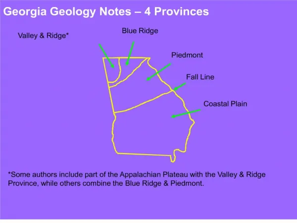
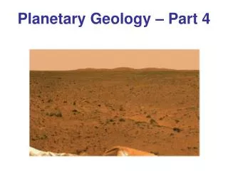
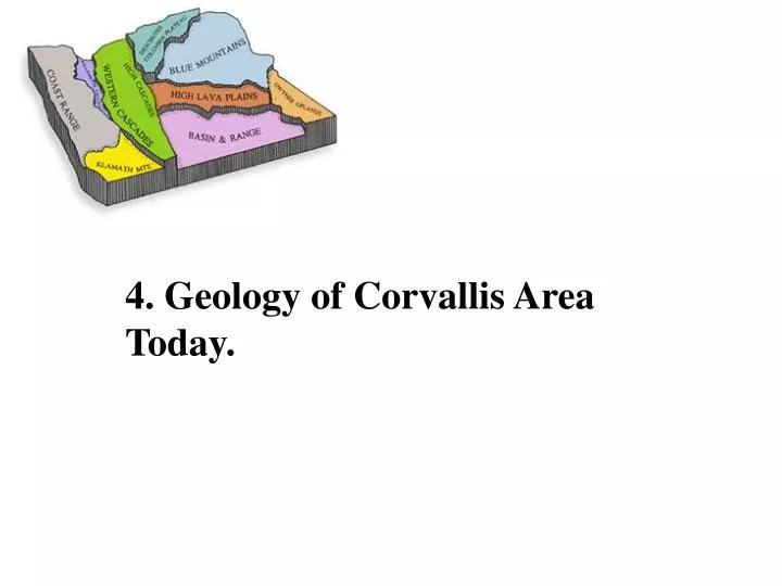
4. Geology of Corvallis Area Today. Eugene, Spencer, Yamhill, and Flournoy formations are the remnants of the ocean sediments that once covered the area. Gravel pushed down by glaciers forces Willamette River to west side of valley. Ocean sediments.

E N D
Eugene, Spencer, Yamhill, and Flournoy formations are the remnants of the ocean sediments that once covered the area. Gravel pushed down by glaciers forces Willamette River to west side of valley.
Ocean sediments Faults caused by collision of the Juan de Fuca plate with North American plate. Pressure of collision cause rocks to move along fault lines (weak places in rock). Faults cause formations to displace.
Area between the Corvallis and King’s Valley faults is uplifting, exposing 54 million year old Siletz Volcanics.
Source: Earthquake Hazard and Risk Assessment and Water-Induced Landslide Hazard in Benton County, Oregon Final Report Wang, Graham, and Madin Oregon Department of Geology and Mineral Industries, June 2001
Corvallis Fault Lewisburg
The Corvallis Fault Although the fault is not currently active, in the past land to the west of the fault was rising and land to the east was sinking. Timberhill Walnut Witham Hill
54 Million Years Ago Vineyard Mountain Pacific Ocean Ocean sediment Siletz River Volcanics - Basalt The geologic history of the Mt View area begins 54 million years ago with formation of an undersea mountain range, the Siletz River Volcanics. Vineyard Mountain is one of these peaks which are made of Basalt, an igneous rock. At this time the Oregon Coast was far to the East.
30 Million Years Ago Rivers dump sediment Vineyard Mountain Pacific Ocean sediments Ocean sediment Siletz River Volcanics - Basalt After millions of years, the undersea mountains are covered with marine sediment including sediment deposited by ancient Oregon rivers.
20 Million Years Ago Vineyard Mountain Western Cascades sediment Pacific Ocean SRV SRV SRV Subduction Zone SRV = Siletz River Volcanics By 20 million years ago, the sediment covered mountains were “Uplifted” above sea-level by an ocean plate colliding with the North American Plate. The Oregon coast was now close to where it is today. Melting of subducted rock leads to volcanic activity in what will become the Cascades.
5 Million Years Ago Vineyard Mountain SRV = Siletz River Volcanics Pacific Ocean sediment SRV SRV SRV Corvallis Fault Subduction Zone King’s Valley Fault By 5 million years ago, sediments covering the Siletz River Volcanics had eroded away – the hard basalt is more resistant to erosion than the soft sedimentary rock. The collision of the two plates results in many “faults” . The area between the Corvallis Fault and the Kings Valley Fault is uplifted, while the areas to the West and East are forced down.
Geology of the Mt View School Area Vineyard Mountain Newport Mt View Mt Jefferson Cascades Coast Range Pacific Ocean North American Plate Corvallis Fault Juan de Fuca Plate At this depth rocks melt Subduction Zone – Place where two plates collide. Major earthquakes occur every 300 to 600 years. Last quake in 1700. Mt View School is just East of the Corvallis Fault. The area to the West of the fault is being “uplifted” including Vineyard Mountain. The area to the East of the fault is moving down.
The Willamette Valley is Wine Country The most complex wines come from vineyards at the boundary between old volcanic soil and glacial deposits or old sandstone. Siletz River Volcanics Good vineyards require good drainage, the correct growing season, and nutrient rich soils.
Quiz 3. Why are vineyards planted on slopes on low hills? 3. Answer: Drainage, self watering, cold air flows down, best soils are associated with weathered volcanic geological features.
The earth’s crust is composed of a patchwork of “plates” that move!! Most volcanoes are located close to where two plates collide
Quiz 4. True or False? Most volcanoes are located near two colliding plates. 4. Answer: True
Axial Seamount Seafloor spreading Seafloor spreading Juan de Fuca Ridge
Juan de Fuca Ridge Juan de Fuca Plate Pacific Plate Pacific Plate Juan de Fuca Plate An Ocean Ridge is where two plates are separating. At the Juan de Fuca Ridge , the Pacific plate is moving West and the Juan de Fuca Plate is moving East.
Quiz 6. What causes the collision between the Juan de Fuca plate and the North American plate? 6. Answer: Seafloor spreading
( like Mt Saint Helens) Subduction The roots of Mt Saint Helens are up to 100 km deep! Magma comes from the Mantle which is 3000º C
What happens at the boundary between plates when subduction occurs? Ocean sediment scraped off the Juan de Fuca Plate by collision with the North American Plate North American Plate Subducting Juan de Fuca Plate
Source: Earthquake Hazard and Risk Assessment and Water-Induced Landslide Hazard in Benton County, Oregon Final Report Wang, Graham, and Madin Oregon Department of Geology and Mineral Industries, June 2001
Source: Earthquake Hazard and Risk Assessment and Water-Induced Landslide Hazard in Benton County, Oregon Final Report Wang, Graham, and Madin Oregon Department of Geology and Mineral Industries, June 2001
Unusual earthquakes measured off Oregon Scientists Baffled by Unusual Swarm of Hundreds of Earthquakes Off Oregon Coast JEFF BARNARDAP News Apr 12, 2008 16:06 EST Scientists listening to underwater microphones have detected an unusual swarm of earthquakes off central Oregon, something that often happens before a volcanic eruption — except there are no volcanoes in the area. Scientists don't know exactly what the earthquakes mean, but they could be the result of molten rock rumbling away from the recognized earthquake faults off Oregon, said Robert Dziak, a geophysicist for the National Oceanic and Atmospheric Administration and Oregon State University. There have been more than 600 quakes over the past 10 days in a basin 150 miles southwest of Newport. The biggest was magnitude 5.4, and two others were more than magnitude 5.0, OSU reported.
Convergence of three tectonic plates: Juan de Fuca, Pacific, and North American
“I guess we shouldn’t have built on the San Andreas Fault!” Cartoon by Sidney Harris