Download
1 / 38
390 likes | 1.05k Vues
Ecosite Decision Support System for Sustainable Forest Management in Manitoba. Project Overview. Partnership Approach. Maximizes the opportunity to share available ideas, information, existing data and costs (financial support)

E N D
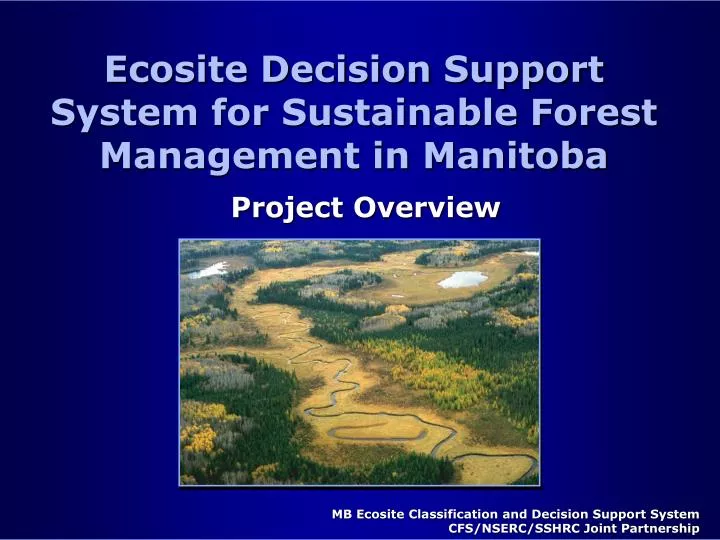
Ecosite Decision Support System for Sustainable Forest Management in Manitoba Project Overview
Partnership Approach • Maximizes the opportunity to share available ideas, information, existing data and costs (financial support) • Provides a forum for knowledge transfer among participants and interested stakeholders • Promotes the use of the system across an array of users • Ensures that the benefits of the project are immediately available
University of Manitoba Tembec - Pine Falls Tolko Manitoba LP Canada Inc. GeoSpatial International ManitobaModel Forest Manitoba Conservation Manitoba Hydro Ducks Unlimited Canada Contributing Partners
National Financial Awards • Canadian Forest Service (CFS) • Natural Sciences and Engineering Research Council of Canada (NSERC) • Social Sciences and Humanities Research Council of Canada (SSHRC)
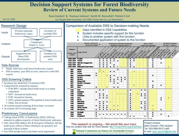
Background • A new approach for an SFM Decision Support System (DSS): • to benefit a diverse array of users of forest resource information • DSS based upon a land classification at a level useful for management, using: • Canada Committee on Ecological Land Classification (CCELC) created in 1976 • Forest Ecosystem Classification (FEC) for Manitoba developed in 1995 • An Ecosite-level classification unit required
What is an Ecosite? • Unit Established by the Canada Committee on Ecological Land Classification • spatial unit between lower order ecoelements and the ecosection level • mappable at scales of 1:10,000 to 1:20,000 with areas of 10-1,000 ha • relevant to resource use decision making (habitat, succession, land use, forestry, etc.) • the fundamental unit for the Manitoba DSS • the level at which biodiversity and recreational associated values will be incorporated
Project Goals • Develop a methodology for consistent classification of ecosites and associated forestry/non-forestry values • Build upon existing lower-order ecoelements • e.g. aerial photo interpretation - stand delineation/typing, PHA. • Produce a common communication tool • e.g. resource managers, users and stakeholders • Assist in forest resource management decision-making processes
Ecosite Classification for Manitoba • Project to utilize a mapping approach: • refine already available V- and S- Type ecoelements in the Manitoba FEC • formulate a consistent classification key and ecosite descriptions • Ecosites are based upon abiotic features that generally remain stable and biotic associations • Includes terrestrial and aquatic systems
Ecosite Development Process • Preliminary Manitoba ecosite key and descriptions (completed 2001) • review of existing ecosites and keys from similar jurisdictions • integration of Manitoba FEC V & S Types • draft preliminary key for field testing and revision for Manitoba • 40 preliminary ecosites • refining ecosite-ecoelement relationship
Ecosite Development: Technical Review • Review preliminary ecosites key and descriptions (winter 2001) • features to delineate ecosite polygons • associations of ecoelements • survey methodology • integrate with partners • e.g. Manitoba Forest Lands Inventory Technical Advisory Committee (FLITAC) • Ducks Unlimited (for wetlands)
Field Trial & Data Collection (2002-2003) • Sample site locations determined in conjunction with partners • Utilize new and existing data including already typed polygons, PHA and other data as available • incorporate information from Duck Mountain pilot project • Work with industry partners to field test ecosite keys
Post-field Work • Utilize information from on-ground data collection and test trials of the keys • refinement of the ecosites key • including additions to FEC V & S - Types • ecosite description fact sheets including associated ecological values • Workshops to review progress and ensure data transferability • Development of DSS in 2003 • incorporate user needs and associated values
Biodiversity: Goals and Objectives • Objective is to incorporate biodiversity values into our DSS and the Ecological Land Classification of Manitoba • considers the scaling properties of biodiversity from the ecoelement to landscape scale • focuses on habitat structural elements • utilizes a mapping approach to identify areas of high diversity
Measuring Diversity For DSS • The Ecosite sampling and mapping methodology previously discussed is compatible with assessing diversity • Diversity has strong scaling properties from the ecoelement to landscape scale
Diversity hierarchy • Landscape • Abiotic and Biotic relations • Number of community types • Spatial arrangement • Community • Interactions among populations • Species composition • Guilds • Population • Interactions of individuals with habitat • Species viability • Genetics (Subspecies)
Diversity as an Associated Value • Landscapes are the ‘unit’ on which we manage forest biodiversity • we incorporate diversity into the DSS by building links between levels of the hierarchy: • ecoelement based diversity principles to landscape-level • ecoelement measures of habitat structure to landscape pattern • Measures of habitat structure and spatial pattern included in DSS at Ecosite scale
Scaling Diversity to the Ecosite-level • Diversity from measuring forest ecosite pattern on the landscape: • from Manitoba FRI, remotely sensed imagery and ecosite polygon maps (e.g. DU) • assesses diversity among clusters of ecosites • Examine habitat structure along toposequences: • assesses habitat diversity as changes in forest structure within the ecosites (e.g. L-P) • aerial survey with paraglider (scaling-up) • Approach emphasize habitat diversity
DN X-Coordinate Position on Landscape Digital Number (DN) Grey Scale Mapping Ecosite Habitat Structure: Toposequences
Advantage of Habitat Structure/Scaling Approaches • Complete species and RTE lists, genetic studies etc. are ideal, but: • cost prohibitive • requires intensive sampling over entire season • species are often missed (RTE) or some are never counted (insects, mosses, etc.) • time scale, structure and pattern on the landscape often not considered • Habitat approach provides measures compatible with forest management • spatially explicit, mappable, can be examined over time
Ecosite DSS for Manitoba: Incorporating Recreation Values Recreation Habitat Suitability Index
Context • Forest recreation takes a variety of forms with each requiring specific environmental conditions • Therefore individual forest recreation types can be seen as “species” with distinct habitat requirements • To date most forest recreation research has attempted to ascribe economic value • We need to identify preferred habitat requirements for recreation “species”
Goals and Objectives • To integrate recreational values into Ecosite DSS for sustainable forest management in Manitoba • inventory of outdoor recreation activities and environments • develop a recreation atlas for the province • identify feasibility of using recreation habitat suitability indices in forest planning and management
Methodology Phase 2 Phase 1 Phase 3 Prior knowledge GIS Layer Expert Interviews Spatial Model Species-environment relationship GIS Layer Grey Literature Species distribution map Analysis of species-environment relationship GIS Layer Academic Literature Species Observations
Phase 1 Overview • Expert interview - Delphi approach • Site inventory • Literature/media review • Determine landscape criteria to model recreation habitat suitability indices
Preliminary Grey Literature Inventory • Forest recreation represents a diverse array of activities Angling 60 41 Hunting 36 Wildlife Viewing Snowmobiling 35 Canoeing 33 X-country skiing 29 27 Hiking 23 Camping Swimming 23 Power Boating 18 # of References
Interview Step Methodology • Will approximate a snowball sampling technique • Sampling concludes when significant repetition occurs • Experts will provide: • diverse perspectives • data on landscape requirements • specific activities and intensities
Phase 2 Overview • Based on phase 1 preliminary sites identified • document what people do and where • Link activity with ecoelements • creates the potential for future ecosite identification • Field trial for specific recreation types • RHSI (recreation habitat suitability index)
Phase 3 Overview • Forest recreation atlas/RHSI at ecosite level as part of DSS (2003) • forest recreation activities in Manitoba are diverse • an atlas will assist in supporting SFM • RHSI’s likely to have complex distribution
Ecosite Decision Support System for Sustainable Forest Management in Manitoba Concluding Remarks
Summary • Foundation ecological classification established • refinement continuing • Incorporation of associated non-timber values for biodiversity and recreation • ongoing iterative process • Closely linked to sustainable forest planning and management • cooperative partnerships established • developing a DSS integrating a range of forest values for ease of application by the forest industry