Download
1 / 23
230 likes | 821 Vues
Wolfgang Leister. GPS Global Positioning System. Translated and adapted by Beate Heilemann May 2006. GPS (Global Positioning System). How does GPS work ?. Introduced in 1973 in USA for military purposes 24 satellites, which send signals and their own positions Receiver which

E N D
Wolfgang Leister GPS Global Positioning System Translated and adapted by Beate Heilemann May 2006
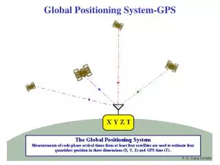
How does GPS work ? • Introduced in 1973 in USA for military purposes • 24 satellites, which send signals and their own positions • Receiver which receives signals from several satellites
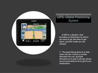
GPS Receiver • Receives signals from several satellites • The positions of the satellites are known • GPS receivers calculate theircurrent position and the precise time • The GPS receiver calculates its own position • Convertes to degrees or UTM
When does GPS work? • Your GPS must have free visibility to at least 3 satelittes (Works much better with 4) (3 satellites = unreliable and without height measuring) • The satellite’s schedule must be known • Trees (forest), walls (tall buildings), mountain slopes, certain weather conditions – all these can confuse your GPS • Your GPS needs power! Always Remember batteries!
Where can I start my GPS • Indoors ? • Not possible • In car, bus, train? • Limited possibilities, but possible by the windows • Takes a long time, but does work in general • In towns and cities • Limited visibility to the sky • Takes a long time to warm up • Not precise (ca. 100 meters divergence)
CoordinatesThe 2 mostly used coordinate systems worldwide • UTM (Universal Transverse Mercator) • Grades / minutes/ seconds (the Nautical coordinate system) • Local coordinate systems (out-dated): German Grid, Swedish Grid, NAD, ED etc. etc etc.etc.. • Where is the referanse?(In the left corner)
UTM Universal Transverse Mercator • 60 x 6° stripes
32V 0596700 UTM 6649260 UTM • In the middle: 500 000 • Measured in meters in both directions
What does the position show us? N 43°03.150 E 074°28.317 • Degrees (nautical coordinates) • UTM ( Universal Transverse Mercator) (metric coordination system) • Better for use on land This is at Manas air base! 43T E 0456996 UTM N 4766780
GPS-use in Practice Which functions are pliable in the mountains? Cases: • Where am I? • How far is it to ...? • How do I get to ...?
Always check if the answer from your GPS makes sense!!! Check the map datum Check the coordinate system Turn on the GPS ... • Turn on the on/off-button • Wait for the satellites • 2D Nav • 3D Nav • Preciseness • GPS can be used when the precision is good enough
Read and save positions • Actual position • Shows directly • Saves as waypoint • New position • «Mark» and edit
Save the position You need: • GPS • MAP • Turn on the GPS • Read the coords from the map and log your GPS • Or «Mark» when you are visiting the spot 32V 0596700 UTM 6649260
Direction • When you are MOVING the GPS can calculate the direction. • «GOTO» function show with an arrow in which direction you must go. • Held the GPS in the correct direction.
Case from the Norwegian mountainsTick fog at the hilltop St. Pål • Fog at the hilltop St. Pål, visibility 20 meters • Snow-covered without tracks or trail marks • Read the coords to Klemsbu (shelter) at the map • Log as waypoint • Push “Goto” and choice «Klemsbu» • Follow the arrow (but be aware of steep slopes and cliffs) Geiteryggen (Staffed cabin) Snow /Fog St. Pål Klemsbu (shelter) Finse (Staffed cabin)
Digital maps • You can buy digital maps (on CD) and download to you GPS. Expensive – at last in Norway. “The Oslo-area” costs $ 100.- • Warning. Use ordinary maps as well. The display on your GPS is not good enough for overall views.
Where are the traps? • Wait till you have got sufficient satellites Sometimes the satellites are in a unfavourable position • Wait a bit and check that the accuracy is ok • NB Be aware of typing in wrong ciphers • Check that you have got updated information. (sometimes this can take quite some time...)Remember. Batteries don’t last for ever.
Good advices • Always bring with you map and compass! • Use the ruler on the compass to read the coords on the map! • Do not rely too much on : altitude measuring, speed, direction, time of arrival • Using you GPS when walking: Easy to stumble!!! • Remember the GPS is calculating air line. Mind the terrain (steep slopes, rivers and other obstructions) • Always have extra sets of batteries with you
Fun to use your GPS in the mountains!!! At the western part of Norway