Download
1 / 52
520 likes | 989 Vues
River and Lake Water Level Monitoring in Africa. Philippa Berry De Montfort University, UK & J é r ô me Benveniste European Space Agency . Overview. Radar Altimetry Missions ERS-1 ERS-2 ENVISAT Retracking Waveform sequence over Africa Near Real Time Pilot Demonstration

E N D
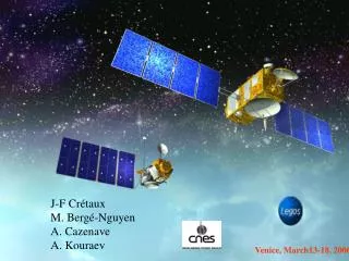
River and Lake Water Level Monitoring in Africa Philippa Berry De Montfort University, UK & Jérôme Benveniste European Space Agency Tiger Workshop 2006 - Cape Town
Overview • Radar Altimetry Missions • ERS-1 • ERS-2 • ENVISAT • Retracking • Waveform sequence over Africa • Near Real Time Pilot Demonstration • Geographical River and Lake masks • Validation against river gauges • Validation against SGDR • Capabilities and limitations • Examples over lakes • Examples over rivers • The Envisat Radar Altimeter Ultra Stable Oscillator Correction • Discussion Tiger Workshop 2006 - Cape Town
ESA RA-1 & RA-2 • ERS-2 long time series at 35 days sampling • Envisat continues time series, also additional mode allows terrain to be sampled even over mountains. • Near Real Time capability permits generating height data within within 3 days of measurement Tiger Workshop 2006 - Cape Town
ERS-2 waveform sequencing across Africa Ocean type echo Very fat echofrom high surface roughness Bright thin echo from still water Tiger Workshop 2006 - Cape Town
South American NRT Mask To produce reliable NRT mask the Envisat SGDR data were run through the full mask to generate products, these were assessed and only the locations of clean time series were included in the final NRT mask. NRT products are now generated globally. Work continues on enhancing the system to retrieve more targets (grey parts of mask). Tiger Workshop 2006 - Cape Town
NRT African Mask + Products Tiger Workshop 2006 - Cape Town
Global NRT mask This is the first release of the global NRT mask. Work continues towards monitoring remaining targets by increasing the waveform analysis and retracking and enhancing the selections mask. Tiger Workshop 2006 - Cape Town
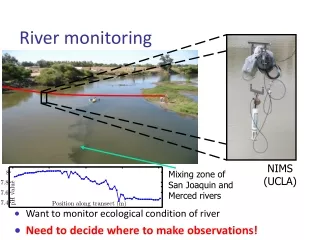
Requirement of an Accurate mask To measure heights accurately using a fully automated system, a very detailed mask is needed, to select out only signals from water. Tiger Workshop 2006 - Cape Town
Validation Extensive validation of results made against gauge stations. Example shown here from Amazon basin. Retracking enables accurate heights to be generated. Tiger Workshop 2006 - Cape Town
VALIDATION Rio Negro Tiger Workshop 2006 - Cape Town
VALIDATION Rio Amazonas Tiger Workshop 2006 - Cape Town
NRT over Lake Debo This figure shows the continuing monitoring over lake Debo from ERS2 (blue), Envisat (red) with two NRT points plotted (cyan). Tiger Workshop 2006 - Cape Town
Histogram of NRT to SGDR differences over Africa 2 cm Tiger Workshop 2006 - Cape Town
Niger River Niger River
Time series over Congo Congo time series ERS2 ERS2 Envisat ERS2 Tiger Workshop 2006 - Cape Town
All Possible Measurements on the Congo These pictures show everywhere that we have useable waveform data over the Congo. Every circle is another measurement. We are working on the River and Lake system with the aim of retrieving measurements from every location shown. Tiger Workshop 2006 - Cape Town
Example ERS2 Time Series over Africa Lake Kariba Lake Kivu 1995 1995 2004 2004 River Nile River Niger Tiger Workshop 2006 - Cape Town
Envisat RA-2 Time Series over Africa Lake Kariba Lago do Cahoro Bassa 2002 2002 2006 2006 Congo Lake Upemba Tiger Workshop 2006 - Cape Town
Time Series over African Rift Valley lakes from ERS2 Red dots show mean position of altimeter measurements - one time series for each dot. Note that the best time series are selected for distribution within the NRT system using the NRT mask. Tiger Workshop 2006 - Cape Town
Time series from ERS2 Lake Malawi Lake Malawi Tiger Workshop 2006 - Cape Town
Time series from ERS2 Lake Tanganika Tiger Workshop 2006 - Cape Town
Time series from ERS2 Lake Victoria Tiger Workshop 2006 - Cape Town
Lake Volume Change - first results Tiger Workshop 2006 - Cape Town
NEAR REAL TIME DEMONSTRATION PILOT • Radar Altimeter waveforms and geophysical corrections are fetched directly from the Envisat ground segment • The near real time River&Lake processor is run as soon as the data is received • The “River&Lake for Hydrology” (RLH) output product is stored in the web site • The longest lag is the availability of the DORIS Interim orbit (3~4 days) • This will improve to 3 hours when the DORIS Navigator orbit is fully processed in real time Tiger Workshop 2006 - Cape Town
Near-real Time Products: • NRT system demo is on since October 2005 • Stopped since March 2006, restarted November 2006 • Data within 3 days • Very good agreement indeed with SGDR data, meaning that the NRT heights are accurate within a few cm • Outputs will be assessed and mask upgraded to include additional sites periodically Tiger Workshop 2006 - Cape Town
River and Lake Products Website http://earth.esa.int/riverandlake Tiger Workshop 2006 - Cape Town
A typical Time Series SAMPLE PAGE FOR HISTORICAL PRODUCTS Each sample page has the same layout Information Time series Products download Tiger Workshop 2006 - Cape Town
SAMPLE PAGE FOR NEAR REAL TIME PRODUCTS THE NEAR REAL TIME IS MADE AVAILABLE VIA THE RIVER AND LAKE WEB SITE http://earth.esa.int/riverandlake Tiger Workshop 2006 - Cape Town
SAMPLE PAGE FOR NEAR REAL TIME PRODUCTS THE NEAR REAL TIME IS MADE AVAILABLE VIA THE RIVER AND LAKE WEB SITE http://earth.esa.int/riverandlake Tiger Workshop 2006 - Cape Town
SAMPLE PAGE FOR NEAR REAL TIME PRODUCTS Lake Debo NRT Validation NRT http://earth.esa.int/riverandlake Tiger Workshop 2006 - Cape Town
NEAR REAL TIME PRODUCTS AFRICA - Lake Volta Tiger Workshop 2006 - Cape Town
NEAR REAL TIME PRODUCTS AFRICA - Lake Rudolph Tiger Workshop 2006 - Cape Town
NEAR REAL TIME PRODUCTS amount of data for one day Tiger Workshop 2006 - Cape Town
NEAR REAL TIME PRODUCTS All Data generated in Near Real Time over one 35 day cycle Location of data since 25 October Tiger Workshop 2006 - Cape Town
ENVISAT RA2 USO Anomaly • RA2 has shown (since Feb 2006) an anomalous behaviour of the Ultra Stable Oscillator (USO) clock period. • The anomaly consists of an offset of about 5.6 m and orbital oscillations of ~20 cm in the EnviSat RA-2 range values • Consequence geophysical applications of RA-2 sea level measurements have been hindered since USO anomaly started • The River and lake NRT system has been halted Tiger Workshop 2006 - Cape Town
20 cm 1 orbit Tiger Workshop 2006 - Cape Town
EnviSat RA2 USO anomaly • Solutions: Two different models and corrective algorithms have been implemented since then: • The first model, developed by CLS (France) • currently being used to correct the geophysical range values (at 1s rate). Only the corrections (and not the corrected output L2 products) have been provided (through the ESA web portal http://earth.esa.int/pcs/Envisat/RA2) so that users can correct their own products. • The second model, developed by R. Scharroo (Altimetrics LLC, USA) • has been implemented and used at ESRIN to correct the L1b RA2 products, that are given as input to the River & Lake processor for further computation of the elevations. Tiger Workshop 2006 - Cape Town
EnviSat RA2 USO anomaly • A comparison between the two corrective models has been performed in order to assess their validity. • The following plot illustrates the differences between the two models, applied to ~6 h of data on 14th October 2006. • Differences of up to ~100 picoseconds in the Ku-band window delay are shown, that are equivalent to a difference of up to13 mm in range or elevation Tiger Workshop 2006 - Cape Town
EnviSat RA2 USO anomaly 13 mm Tiger Workshop 2006 - Cape Town
River and Lake processor results • The uso corrected Level 1b products, as well as non-USO-corrected L2 IGDR products (needed for the geophysical corrections) are now given as input to the River & Lake processor for a correct determination of river and lakes water level. Tiger Workshop 2006 - Cape Town
River and Lake processor results • The following African rivers are processed in near real time by the River&Lake system : • Senegal, Niger/Benue, Volta, Nile, Congo, Zambezi, Limpopo and Orange • The following African lakes are processed in near real time by the River&Lake system: • Albert, Aswuan, Bangweulu, Cahora Bassa, Chad, Chilwa, Ndombe, Edward, George, Kainji, Kariva, Kivu, Kyoga, Lac de Buyo, lac de Kossou, lac de lagdo, lac de Manantali, lac de Selingue, Malawi, Mbakaou, Mweru, Mweru Wantipa, Nasser, Niangay, Nyasa, Shiroro, Tana H’ay’k, Tanganyika, Turkana, Victoria Tiger Workshop 2006 - Cape Town
River and Lake processor results • RA2 data from 2005 have been given as input to the R&L processor to illustrate the outputs of the processor over Africa • The plotted values are elevation differences with respect to climatological mean values. Tiger Workshop 2006 - Cape Town
River and Lake processor results [m] Tiger Workshop 2006 - Cape Town -20 0 -10 10 20
NEAR REAL TIME PRODUCTS THE MASK CAN BE ENHANCED TO ATTEMPT RETRIEVAL OVER YOUR PROJECT’S AREA http://earth.esa.int/riverandlake Tiger Workshop 2006 - Cape Town
NEAR REAL TIME PRODUCTS SIGN UP IN THE DISTRIBUTION LIST OF THE NRT PILOT DEMO VIA THE RIVER AND LAKE WEB SITE or write at rl.info@plod.esrin.esa.it http://earth.esa.int/riverandlake Tiger Workshop 2006 - Cape Town
BURST ECHOES - RESEARCH CONTINUES Tiger Workshop 2006 - Cape Town
BURST ECHOES - RESEARCH CONTINUES Tiger Workshop 2006 - Cape Town
Discussion • The ERS2 measurements have allowed generation of long time series of inland water heights over Africa. • ENVISAT continues this valuable time series: additionally, its Near-Real Time capability allows generation of heights within 2-3 days of measurement. • The spatial sampling permits data over a huge number of inland water targets to be gathered; the drawback is the low temporal sampling which permits annual and seasonal variations to be observed but does not allow high frequency changes to be identified. • These data are provided by ESA to Users: work continues to enhance this pilot system and recover heights from all the available water crossings worldwide. Tiger Workshop 2006 - Cape Town