Download
1 / 22
220 likes | 476 Vues
Brunswick/Fernandina/Jacksonville Right Whale Ship Strike Reduction Measures. Barb Zoodsma NOAA Fisheries Southeast Region. SEUS Region. Area inclusive of just north of Brunswick, Georgia to Cape Canaveral, Florida Winter calving area. SEUS Region. Features: Calving Area Critical Habitat

E N D
Brunswick/Fernandina/Jacksonville Right Whale Ship StrikeReduction Measures Barb Zoodsma NOAA Fisheries Southeast Region
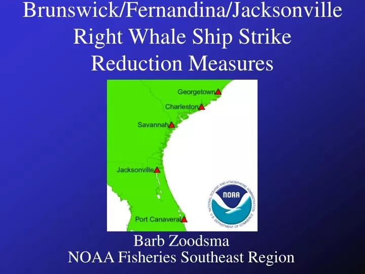
SEUS Region Area inclusive of just north of Brunswick, Georgia to Cape Canaveral, Florida Winter calving area
SEUS Region • Features: • Calving Area Critical Habitat • MSR Area: WHALESSOUTH • Ports: • Brunswick, GA • Fernandina, FL • Jacksonville, FL • Cape Canaveral, FL
Seasonal Use of SE US Region • Only known calving ground for North Atlantic Right Whales • Seasonal use (Dec. – Mar) • Calving females • Other population segments • High proportion of reproducing females in this area (most vital segment of right whale population) • Protecting reproductive potential is essential for recovery of the species.
Temporal Distribution of SEUSRight Whale Sightings Source: NMFS Unpub. Data. Sightings through 01/02 calving season and south of 31o30’ latitude
Spatial Distribution in SEUS • Whales distributed fairly close to shore • High use area from Brunswick to south of Jacksonville Brunswick Fernandina Jacksonville
MSR Ship Tracks • Provides measure of traffic density through critical habitat • No defined approaches to these ports • Several “de facto” traffic lanes • Highest use port is Jacksonville Source: Leslie Ward, Florida Marine Research Institute
SE US Ship Strike Mortalities1991 - 2002 • 3 documented ship strike mortalities
Proposed SEUS Operational Measures • USCG Port Access Route Study (PARS) for Brunswick, Fernandina, and Jacksonville • Objective: full assessment of potential routing on: • Risk reduction to right whales • Navigational safety • Economics of affected ports
Proposed SEUS Operational Measures • PARS ensures full hearing of any routing measure considered. • Allows for integration of views: maritime safety, port elasticity, and right whale protection
SE US Measures • Seasonal Management Area • Time: December 1 - March 31* • If warranted by PARs: Establish designated routes to reduce risk of vessel/whale collisions • Seasonal speed restrictions (10-14 knots) in lanes *Precise dates to be determined pending further data analysis
SE US Measures (cont.) • Develop an Understanding with Coastal Traffic (lg. rec. vessels, tug/barge, etc.) • Use designated traffic lanes or avoid area the area to maximum extent practicable • Otherwise: Uniform speed restriction (10-14 knots)
SE USSeasonal Management Area* • Northern Boundary: 31°27’N • Southern Boundary: 29°45’N • Eastern Boundary: 81°00’W • Western Boundary: Shoreline • ~24 nmi East of Jax, Fern. (jetties), and Bwk *Precise area pending further data analysis
SE USSeasonal Management Area • Aerial survey data through 2002 • Effort corrected
Jacksonville Increased Transit Time Pilot Buoy @ 4.2 nmi (5 knots) Russell et al., 2003
Dynamic Management • Along the Atlantic seaboard within the EEZ • Certain concentrations of right whales • Outside Time or Area of SMA • Precautionary area established for limited period of time • Vessels must divert or restrict speed Distance, duration and speed subject to further analysis
Savannah Seasonal Management • November – April • Speed Restriction (10-14 knots) • DMA
Proposed Operational Measures for MidAtlantic • ~10-14 knot speed restriction in ~20-30 nmi radius around Port Entrances • Vessels 65’ Note: Precise size of area and timing to be determined pending further analysis of sighting data
Seasonality of Proposed Mid-Atlantic Operational Measures Note: Precise dates to be determined pending further analysis and modeling
Vessel Operating Concerns • Measuring impacts (additional time) for vessels complying with proposed vessel operating restrictions
Economic Concerns • Study: Economic Analysis • Federal Regulations: Formal Economic Analysis
Our Goals • Explain Problem • Explain Approach (Strategy) • Initiate Dialog • Industry Input