Download
1 / 28
280 likes | 599 Vues
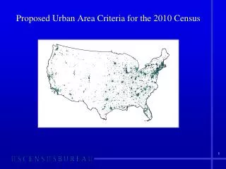
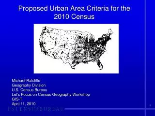
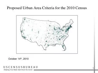
2010 Public Use Microdata Area Proposed Criteria. Overview. Brief History Proposed Criteria Discussions New Challenges Since 2000 Proposed Criteria – Changes for 2010 Proposed Guidelines. Brief History.

E N D
Overview • Brief History • Proposed Criteria Discussions • New Challenges Since 2000 • Proposed Criteria – Changes for 2010 • Proposed Guidelines
Brief History • PUMS first created for the 1960 Census and were published for state geography (i.e., one PUMS per state) • For the ’60, ’70, and ’80 censuses, the following geographies were used for the publication of PUMS data: Divisions States Metropolitan areas/Non-metropolitan areas Urban/rural/central cities/urban fringe County groupings
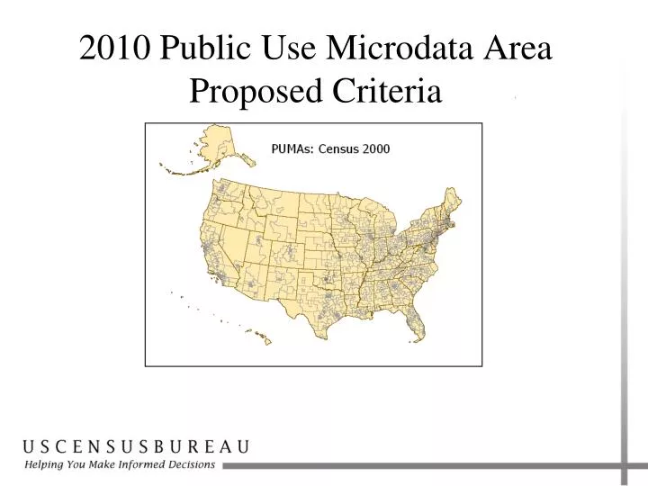
Brief History • PUMAs first defined for the 1990 Census • 5%, 3% and 1% PUMS were provided for corresponding PUMAs with a minimum population threshold of 100,000 • 5% and 3% PUMS were published for the same PUMA geography: • nested within states • built on counties, places, and tracts • 1% PUMAs: • could cross state boundaries • built on metropolitan areas/non-metropolitan areas and central cities/non-central cities
Brief History • 2000 PUMAs • 5% and 1% PUMS were provided for corresponding PUMAs that nested within states • 5% PUMAs were primarly aggregations of counties, MCDs (in New England states), and census tracts. Incorporated places of 100,000 or greater could be defined as a PUMA as well. • 5% PUMAs had a minimum population threshold of 100,000 • 1% PUMAs, “super PUMAs”, were aggregations of 5% PUMAs, with a minimum population threshold of 400,000
Proposed Criteria Discussions • PUMA working group • Multi-divisional working group in which the issues for 2010 PUMAs were vetted and the proposed criteria were initially approved • Divisions represented on the working group: ACSO GEO CLMSO HHES DSSD POP • Meetings occurred in Spring – Summer 2009 • 2009 State Data Center annual meeting • Professional conferences
New Challenges for 2010 PUMAs Annual publication of data for PUMAs: ACS PUMS and ACS estimates • PUMAs that experience population decline are problematic • PUMAs built on entities whose boundaries change frequently over time (especially incorporated place boundaries) are problematic
Overview: Proposed Criteria • Standard PUMAs (one level) • State-based • POW PUMAs and MIG PUMAs • Minimum population threshold of 100,000 throughout decade • Counties and standard tracts as building blocks • Contiguity • Federal American Indian reservation/off-reservation trust land (AIR/ORTL) relationship An asterisk (*) indicates there is a proposed change from the 2000 criteria
PUMATypes • Only one level of “standard” PUMA (PUMA 5 from Census 2000) • Place of work PUMAs (POW PUMAs) and migration PUMAs (MIG PUMAs) are proposed to be county based, consisting of: • a single PUMA for county-based PUMAs • a combination of adjacent tract based-PUMAs so that together the PUMAs compose one or more complete counties PUMA 1 PUMA2 CountyB Boundary Symbology County Tract-based PUMA CountyA PUMA 3 POW PUMA & MIG PUMA POW PUMA I and MIG PUMA I
Population Thresholds • Each PUMA must contain a minimum population of 100,000 • The minimum population must be met at the time of delineation and throughout the decade • Define each PUMA currently experiencing/expected to experience population decline above the minimum threshold to accommodate the decline throughout the decade • PUMAs that fall “significantly below” the 100,000 person threshold will be combined with one or more adjacent PUMAs for ACS PUMS
PUMA Composition: Use of Census 2010 Counties and Census Tracts as Building Blocks • All PUMA types (standard, POW, and MIG) must nest within states • PUMAs will be based on aggregations of counties and census tracts only • Incorporated places and MCDs will not be used as building blocks for 2010 PUMAs. Census tracts may be aggregated to approximate minor civil divisions, incorporated places, or census designated places.
PUMA Composition: Use of Census 2010 Counties and Census Tracts as Building Blocks Provided the PUMA meets the minimum population threshold: • One county may be designated as a PUMA • Two or more contiguous counties may be aggregated to create a PUMA • Contiguous census tracts may be aggregated to create a PUMA • Tract-based PUMAs may cross county boundaries, provided that each PUMA-county part meets a minimum population of 2,400
PUMA Composition: Use of Census 2010 Counties and Census Tracts as Building Blocks • Exclude incorporated places: • Change frequently over time: annexations/deannexations • 2000 PUMAs are not updated as incorporated places change • 2000 POW PUMAs are updated as incorporated places change in practice, as the place of work data are coded to the current incorporated place, and not the incorporated place on which the PUMA was built • Incorporated places often contain numerous enclaves (holes) and exclaves (noncontiguous pieces)
PUMA Composition: Use of Census 2010 Counties and Census Tracts as Building Blocks Exclude minor civil divisions (MCDs): • Some change over time, especially where MCDs are defined coextensive with an incorporated place • In strong MCD states, MCD boundaries are stable, and census tract boundaries almost always follow the MCD boundaries
PUMA Contiguity PUMAs must constitute a geographically contiguous area, except: • A PUMA may be noncontiguous if a county is noncontiguous. • A PUMA may be noncontiguous if a census tract is noncontiguous.
PUMAs and AIR/ORTL • PUMAs should be defined to avoid unnecessarily splitting substantially populated areas of American Indian reservations and off-reservation trust lands for federally recognized tribes • If the AIR/ORTL has a population of <100,000 it should be contained within one PUMA • If the AIR/ORTL has a population of <200,000 it should be contained within no more than two PUMAs Note: Since AIR/ORTL can cross state boundaries this applies to the portion of the AIR/ORTL within a state Note: Standard tracts follow the same criteria (should not unnecessarily split AIR/ORTL), so therefore should be good PUMA building blocks in these areas
PUMA Guidelines • Wherever possible, each PUMA should comprise an area that is either entirely inside or entirely outside a current Core Based Statistical Area (i.e., Metropolitan and Micropolitan Statistical Areas). • The Census Bureau recommends that the number of PUMAs be maximized, and that PUMAs should not contain more than 200,000 people, wherever possible, unless the PUMA is defined for an area that is or will be experiencing significant population decline.
Questions? Vince Osier or April Avnayim Geographic Standards & Criteria Branch Geography Division Washington, DC 301-763-3056 vincent.osier@census.gov april.l.avnayim@census.gov