Download
1 / 14
140 likes | 511 Vues
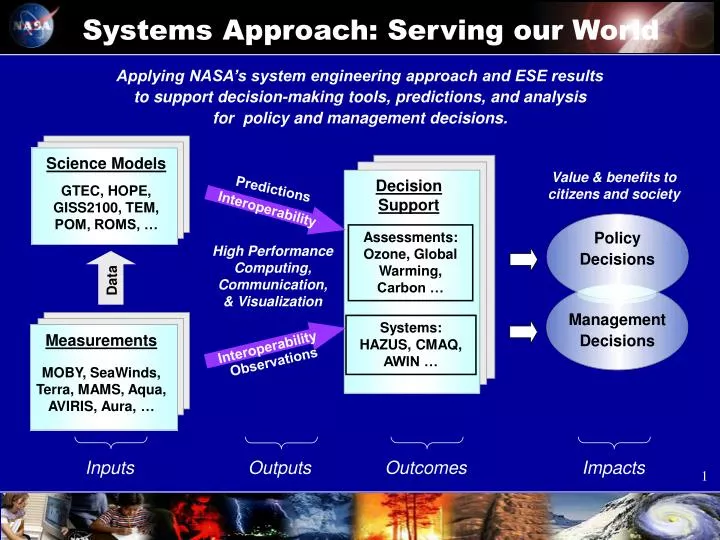
Systems Approach: Serving our World . Interoperability. Interoperability. Inputs Outputs Outcomes Impacts. Applying NASA’s system engineering approach and ESE results to support decision-making tools, predictions, and analysis for policy and management decisions. Science Models

E N D
Systems Approach: Serving our World Interoperability Interoperability Inputs Outputs Outcomes Impacts Applying NASA’s system engineering approach and ESE results to support decision-making tools, predictions, and analysis for policy and management decisions. Science Models GTEC, HOPE, GISS2100, TEM, POM, ROMS, … Value & benefits to citizens and society Decision Support Predictions Policy Decisions Management Decisions Assessments: Ozone, Global Warming, Carbon … High Performance Computing, Communication, & Visualization Data Systems: HAZUS, CMAQ, AWIN … Measurements MOBY, SeaWinds, Terra, MAMS, Aqua, AVIRIS, Aura,… Observations
Mosaic Energy, water fluxes CENTURYLand change/carbon VolQuakeSeismicity HSPFNutrienttransport ANIMO Soilnitrogencycle PRMSPrecipitationrun-off MAESTRO Canopybiomass ROMS Regionalcirculation MOM3 Multi-scale ocean CSIM4 Sea-ice NWW3 Global/regional waves BOMCoastal & shelf seas GOTM Turbulence & mixing CAM/CCMGlobal climate GISS GCMClimate change BEISBiogenic emissions MSISE Density, temperature VAFTAD Volcanic ash PRECISRegional climate LAND OCEANS/ICE ATMOSPHERE GTEC Terrestrial Ecosystem Carbon MM5 Mesoscale Meteorology Atmosphere Catchment LSM Soil Moisture Transport Aries/GEOS Atmos. GCM Poseidon, HYCOM Ocean GCM LOIS Land-Ocean HadCM3 Ocean-Atmosphere COLA Atmosphere-Land/Biosphere ZEUS, CCSMLand-Ocean-Ice-Atmosphere COUPLED MODELS AOM Atmosphere-Ocean COUPMODEL Soil-Plant-Atmosphere Earth System Models
Beyond Scientific Exploration…serving Society Global Change IPCC CCRI NRC NCCTI USGCRP WMO Advanced Weather Prediction NRC NOAA DOD Natural Hazards Nat’l. Hazards Ctr NRC Roundtable SESWG … Earth System Knowledge Earth Science Enterprise Mission: Focus on weather, climate, and natural hazards Operational Imperatives Federal Local State Tribal International Private Sector Science Applications Education Technology & Missions Earth Science Education K-16 & Beyond
Enabling science and technology for • Weather and climate for Energy Forecasting • Sequestration capacity monitoring for Carbon Management • Weather and climate for Agricultural Competitiveness • Weather and natural hazards for Aviation Safety • Weather, climate and natural hazards - Community Growth • Early warning for Homeland Security • Early warning for Public Health • Community preparedness for Disaster Management • Environmental Indicators for Coastal Management • Biological Invasive Species Management • Water Management and conservation • Weather and natural hazards for Air Quality management
National Applications Carbon Management Energy Forecasting Public Health Aviation Safety Coastal Management Water Management Homeland Security Disaster Preparedness Agricultural Competitiveness Community Growth Invasive Species Air Quality
Decision Support Systems CCRI: Carbon Management DSS Aviation Safety: AWIN Energy Forecasting: NREL DSS Public Health: RSVP Homeland Security: OHS Situation Center Disaster Preparedness: HAZUS
Decision Support Systems Community Growth: Urban Growth DSS Water Management: AWARDS Coastal Management: HAB Forecast Invasive Species: NBII/NISC/CBI Agricultural: FAS Forecast Air Quality: CMAQ/Models-3
Spatial Information Cycle Prediction Models NASA ESE Research Private Intn’l Public EOS Data Information System Earth Observing System 24 Measurement Sets Decision Support Systems Standards & Interoperability Tasking Distribution • Evaluate • Verify • Validate • Benchmark Data Distribution/ Management Data Sources/ Measurements Standards- based Products Exploitation Processing
Stakeholder Communities Public Sector Private Sector Policy Sector ESE Applications Program Expand and accelerate the realization of economic and societal benefits from Earth science, information, and technology. International Sector Aerospace Sector Academic Sector Education Sector Science Sector
Enriching Earth Science Education • Provide the Nation with life-long learning opportunities about climate change research • Partner with educators to build human capacity to create effective decision support tools Improving public awareness, appreciation and understanding of Earth system science and encouraging pursuit of careers in science and technology using NASA-unique content and resources
Inspiring the Next Generation of Explorers • Using the Earth System Science concept to contribute to the way Earth science is taught • Influencing each stage of the education pipeline • Teacher-reviewed curriculum materials for K-12; 11,438 teachers trained in 344 workshops • Earth System Science Education curricula for colleges & universities; implemented at 44 to date • Sponsoring ~150 graduate student fellowships directly, with 50 additional students selected each year • Sponsoring 40 early career and education grants • Working with 25 museums to integrate NASA Earth science results into their evolving exhibits • Smithsonian Forces of Change Exhibit on El Nino • Partnering with the National Park Service, the Girl Scouts, Earth & Sky Radio, and others to increase public literacy in Earth science
Learning through Telepresence Context-Sensitive Models & Decision Support Tools Context-Sensitive Education Modules 4-D Internet Visualization Access to continuously updated education modules on Earth science, remote sensing technologies, missions, models, and decision support tools Access to continuously updated databases of Earth science data with capability to view time series Access to continuously updated models and decision support tools for learning how to run scenarios
Educating for the End-to-End Information Flow Petabytes 1015 Terabytes 1012 Gigabytes 109 Megabytes 106 WET VERY DRY DRY WET WET DRY DRY VERY WET COLD WARM COLD Calibration, Transformation To Characterized Geophysical Parameters Interactive Dissemination Interaction Between Modeling/Forecasting and Observation Systems Multi-platform, multi-parameter, high spatial and temporal resolution, remote & in-situ sensing Predictions Access to Knowledge Information Synthesis Advanced Sensors Data Processing & Analysis
Educating People for all Levels Education Earth Science & Technology Future Scientists & Engineers Scientific Discovery Earth System Knowledge Models Earth Science Questions • Measurements & Monitoring • Satellites • Airborne • Ground-based Policy Decisions Assessments Data Products Decision Support Tools Management Decisions New Instruments & Platforms Computational Modeling Capability Adaptation to Operational Uses Visualization Technology Applications