Download
1 / 29
290 likes | 624 Vues
An Overview of the U.S. Integrated Ocean Observing System (IOOS) Jan Newton Applied Physics Laboratory University of Washington What is IOOS ?

E N D
An Overview of the U.S. Integrated Ocean Observing System(IOOS) Jan Newton Applied Physics Laboratory University of Washington
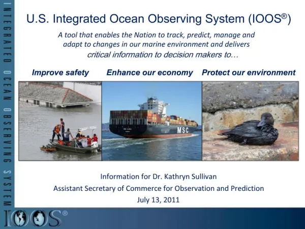
What is IOOS ? The Integrated Ocean Observing System (IOOS) is a coordinated national and international network of observations and data transmission, data management and communications, and data analyses and modeling that systematically and efficiently acquires and disseminates data and information on past, present and future states of the oceans and U.S. coastal1 waters to the head of tide. 1 “coastal” includes the U.S. Exclusive Economic Zone and territorial sea, Great Lakes, and semi-enclosed bodies of water and tidal wetlands connected to the coastal ocean http://www.ocean.us/
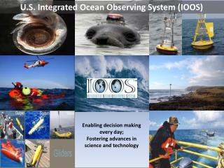
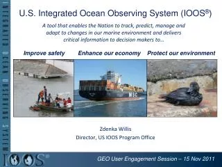
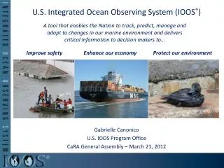
What will IOOS do? The U.S. Integrated Ocean Observing System (IOOS) is developing as a “user-driven”, integrated system of observations and data telemetry, data management and communications (DMAC), and data analysis and modeling that routinely, reliably, and continuously provides data and information required to address seven societal goals: (1) Improve predictions of climate changeand weather and their effects on coastal communities and the nation; (2) Improve the safety and efficiency of maritime operations; (3) More effectively mitigate the effects of natural hazards; (4) Improve national and homeland security; (5) Reduce public health risks; (6) More effectively protect and restore healthy coastal ecosystems; and (7) Enable the sustained use of ocean and coastal resources.
What are the components of IOOS ? • Ocean Observing System • Global Ocean Component • National Backbone of the Coastal Component • Regional Coastal Ocean Observing Systems • Data Management and Communications • Modeling and Analysis Subsystem • Research and Development • Education and Public Awareness
A brief history of IOOS • NOPP established by law in 1997 • NORLC has oversight of NOPP • NORLC recommends an IOOS in 1998-1999 • NOPP establishes Ocean.US in 2000 to implement a user-driven IOOS • Global IOOS and Coastal IOOS • Coastal IOOS to have two components: • National Backbone • Regional Associations
IOOS Background 1. To promote the National Goals of: - Assuring National Security - Advancing Economic Development - Protecting the Quality of Life - Strengthening Science Education and Communication through Improved Knowledge of the Ocean 2. And to Coordinate and Strengthen Oceanographic Efforts in Support of these Goals by: - Identifying and Carrying out Partnerships among Federal Agencies, Academia, Industry, and Other Members of the Oceanographic Scientific Community in the Areas of Data, Resources, Education, and Communication - Reporting Annually to Congress on the Program The National Oceanographic Partnership Program (NOPP) was established by Legislation
National Ocean Research Leadership Council (NORLC) Chair: Administrator, National Oceanic and Atmospheric Administration Vice Chair: Secretary of the Navy Vice Chair Director, National Science Foundation Administrator National Aeronautics and Space Administration Deputy Secretary Department of Energy Administrator Environmental Protection Agency Commandant United States Coast Guard Director United States Geological Survey Director Defense Advanced Research Projects Agency Director Minerals Management Service Director Office of Science and Technology Policy Director Office of Management and Budget
“Ocean.US” established by NOPP NORLC-commissioned reports in 1998 & 1999 recommended establishment of a national capability for integrated and sustained ocean observations & prediction In May 2000: (1) The NORLC directed the establishment of Ocean.US (2) Formation of Ocean.US announced to Congress. To manage the development of an Integrated and Sustained Ocean Observing System (IOOS) for research & operations in the following areas: • Detecting and Forecasting Oceanic Components of Climate Variability • Facilitating Safe and Efficient Marine Operations • Preserving and Restoring Healthy Marine Ecosystems • Ensuring National Security • Managing Marine Resources • Mitigating Natural Hazards • Ensuring Public Health
A brief history of IOOS • NOPP established by law in 1997 • NORLC has oversight of NOPP • NORLC recommends an IOOS in 1998-1999 • NOPP establishes Ocean.US in 2000 to implement a user-driven IOOS • Global IOOS and Coastal IOOS • Coastal IOOS to have two components: • National Backbone • Regional Associations
IOOS Global System • Full implementation of Argo and the global ocean time series observatories. • Successful completion of the Global Ocean Data Assimilation Experiment (GODAE). • Optimizing the global network of observations, and • Enhancing the ocean time series observatories with key biological and chemical sensors.
The National Backbone • Measure and process variables needed by all regional systems, including biological var. • Satellite remote sensing • Reference, sentinel stations • Link to global system • Data standards & exchange protocols Wave Height Ocean Color Surface Temperature
Primary interface with user groups outside federal agencies. • Focal point for data analysis and product development that will have local, regional and national applications. • Terrestrial influence measurements • Many national backbone R&D projects will be first done in regional observing systems. • Development of regional systems is a very high priority
Will IOOS be funded entirely ? • Last year: • S 1400 was passed unanimously in the Senate and, late in the session, the House introduced the complimentary HR 5001 bill. Both bills would have authorized $100’s M for the global, national backbone and regional modules of the IOOS. HR 5001 did not emerge from the House by the end of the session (4 committees were involved). • This year: • S 361 introduced in Senate. Strong bipartisan support from powerful Senators. • House introduced similar IOOS legislation (HR 1489). • The odds: • Good news – GEOSS is a White House priority and Ocean Action Plan stipulates that IOOS will be the ocean observing component of GEOSS. Strong bipartisan support in House and Senate. Ocean Commission strongly endorsed the IOOS. • Bad news – Extremely tight and polarized budget year (Iraq, Social Security, etc.). No funding is identified in Ocean Action Plan. Congress has stated that the ~$4B+ cost for implementing recommendations in COP report are not executable given budgetary pressures. • Bottom line: • Difficult to say – the Hill and the White House (OSTP) does understand that many/most of the COP Recommendations require an IOOS and we’ve hammered home the message that it is affordable.
Northwest Association of Networked Ocean Observing Systems The Integrated Ocean Observing System (IOOS) Regional Association for the Pacific NW
Northwest Association Of Networked Ocean Observing Systems (NANOOS) http://www.nanoos.org
What are we? • A user-driven coastal ocean observing system • “ocean” includes inland marine waters (head of tide to EEZ) • “user-driven” means users define priorities, delivery • A system designed to produce and disseminate ocean observations and related products deemed necessary to the users, in a common manner and according to sound scientific practice • A regional organization through which to integrate and sustain existing observing capability, to strategize for new operational systems, and to provide easy access to data, data products, model forecasts, etc. about regional marine conditions
Who are we? • NANOOS Coordinator: Jan Newton*, University of Washington • Steering Committee: • Antonio Baptista*, Oregon Health and Sciences University • Jack Barth*, Oregon State University • Robert Bohlman, Marine Exchange of Puget Sound • Patrick Corcoran, Oregon Sea Grant Program • Mike Kosro*, Oregon State University • David Martin*, University of Washington • Greg McMurray, Oregon Dept of Land Conservation & Development • Ian Miller, Surfrider Foundation • Jay Pearlman, The Boeing Company • Terry Wright, Northwest Indian Fisheries Commission * Chartered Interim Steering Committee
Potential NANOOS partners/participants (not exclusive): Academia (UW, OSU, OHSU, WWU, PSU, UO, etc.) NOAA (PMEL, NWFSC, AFSC, NOS HAZMAT, etc.) US Coast Guard (primarily 13th District) US EPA, USGS, US Army Corps of Engineers, US Navy Tribal Governments Northwest Indian Fisheries Commission Washington and Oregon Sea Grant Programs Washington State Ferries Washington Depts of Ecology, Fish & Wildlife, Health, Natural Resources, etc. Oregon Depts of Environmental Quality, Fish & Wildlife, Geology & Mineral Industries, Land Conservation & Development, etc. National Estuarine Research Reserves (South Slough, Padilla Bay) Olympic Coast National Marine Sanctuary Puget Sound Water Quality Action Team California Coastal Commission, etc. Institute of Ocean Sciences, etc, Canada NGOs (Surfrider Foundation, TNC, People for Puget Sound, etc.) Regional Aquaria and Marine Science Centers Marine Exchanges of Puget Sound and Columbia River Northwest Marine Trades Association Fisherman’s and Shellfish Grower’s Associations West Coast Seafood Processors Association The Boeing Company and other technology/data industry WET Labs Inc., Seabird Inc., Biospherical, and other marine sensor industry
A brief history of NANOOS • Received $100K 1st year planning grant from NOAA Coastal Services Center (late 2003) • Pacific Northwest Regional Ocean Observing System Workshop I: 23-24 October 2003, Portland State University, Portland, OR • Signed a Charter establishing NANOOS • Appointed an Interim Steering Committee • David Martin (UW), Jan Newton (UW), Antonio Baptista (OH&SU), Jack Barth (OSU), Mike Kosro (OSU) • Two pilot proposals submitted to NOAA CSC; one funded regarding estuaries and coasts • NANOOS Governance Workshop II:5-7 May 2004, Oregon H&S Univ., Beaverton, OR • Gained consensus on Governance Structure and Approach • Held a User Needs Forum • Gained consensus response on prioritization for federal and regional activity • Received 2nd year developmental grant from NOAA with support for Coordinator • Hired NANOOS Coordinator (J. Newton) on 1 November 2004 • 3rd year developmental proposal recommended for funding by NOAA • NANOOS System Design Workshop III:28 Feb-1 Mar 2005, NOAA-PMEL, Seattle, WA • Gained input on priority user needs • Gained input on system design responsive to user needs
3rd Proposal Focuses on Accreditation Interim Steering Committee Users Advisory Group Governing Council NANOOS Coordinator Executive Committee Officers, NANOOS Executive Director, Standing Committee Chairs DMAC Education Workshops User/Stakeholder Outreach Standing Committees: Operations Committee Data/Information Management and Communications Committee Modeling and Analysis Product Committee Science and Research Committee Education and Outreach Committee Nominating Committee Other NANOOS Priorities A B
The way forward • HOW: Sign an MOA to provide governance for NANOOS. • WHO: Continue to actively engage stakeholders, broaden diversity of participants. • WHAT: Scope NANOOS system design based on user-driven needs for ocean data products.
1.NANOOS MOA Memorandum of AgreementTo Establish and Implement the Northwest Association of Networked Ocean Observing Systems • Outlines structure and responsibilities for governance, membership, fiscal, data and other components of NANOOS • Required for NANOOS to be accredited • Non-binding, implies “general intention” • Signage = membership • On web • 1 June 2005 goal for 10 signatories
2. Engage stakeholders • Added six new non-academic members to NANOOS Steering Committee (SC) • Continued outreach by NANOOS SC and focused effort by NANOOS Coordinator on various scales • NANOOS Pilot forming User Groups around specific science/management issue, e.g., erosion, hypoxia, etc., in specific areas, e.g. South Slough, Hood Canal • Workshops and outreach to continue to collect input on user needs for data and data products; gain new members and partners
ID of PNW User Groups From NOAA/NANOOS analysis: • Marine shipping and oil transport/spill remediation • Search and rescue • Shellfish fishery and aquaculture • Marine recreation • Natural resource/environmental management • National and homeland security • Finfish aquaculture • Research institutions • Education • Commercial groundfishing • Crab fishery
3. System Design GOAL: To identify and prioritize user-driven data products and design the observational system that can be responsive to these needs. In 3rd Planning Workshop, we gained input on: * What are the specific, prioritized data products and who are the users who need these? * Based on these prioritized products, what variables are needed? * Given the priority variables identified, what are the system design priorities (location, measurement capabilities, phasing, etc.) for various technologies: Buoys; HF; Satellite infrastructure; Surveys; Other platforms; Models; Data output ? Based on this and other input, a system design “vision document” will be drafted, compiling and synthesizing the information, and will be used for outreach and further refinement.
Puget Sound, WA CORIE: Columbia River Estuary South Slough Estuary, OR