Download
1 / 38
400 likes | 559 Vues
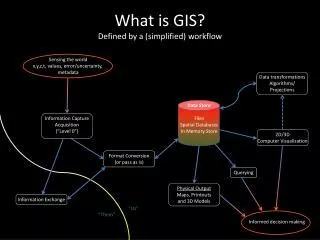
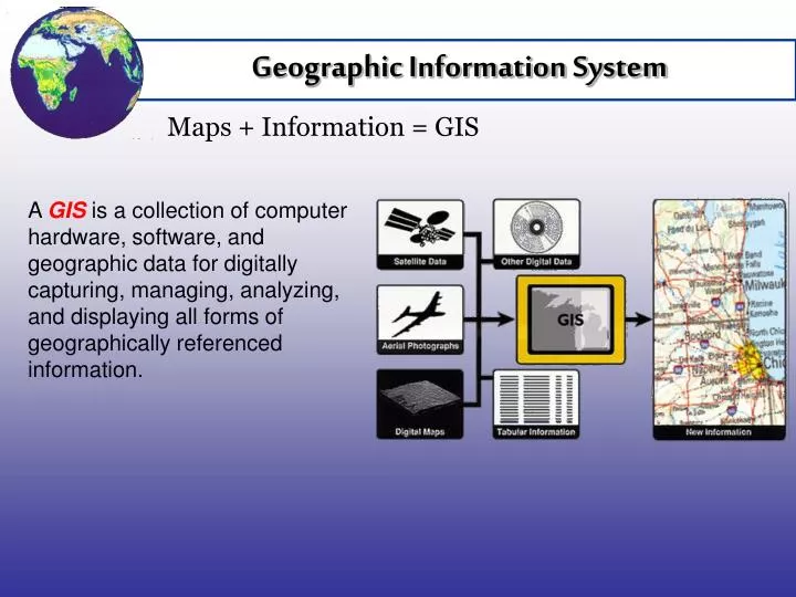
Geographic Information System. GIS Defined. Maps + Information = GIS. A GIS is a collection of computer hardware, software, and geographic data for digitally capturing, managing, analyzing, and displaying all forms of geographically referenced information. GIS Components. GIS Components.

E N D
Geographic Information System GIS Defined Maps + Information = GIS A GISis a collection of computer hardware, software, and geographic data for digitally capturing, managing, analyzing, and displaying all forms of geographically referenced information.
GIS Components GIS Components A GIS is a comprised of five components: people, hardware, software, data, and methods. People are required to collect data and use methods, hardware, and software to manipulate data.
Reality GIS Layer Feature, Layer, Spatial Data Defined GIS integrates all the layers…to create digital reality. A geographic feature is any real-world object on a map, such as a single building. A layer is the visual representation of a set of geographic features. Layers must contain spatial data. Spatial data indicates the geographic location and shape of the feature. In the example, buildings, school districts, streets, zip codes, cities, and counties are layers that are combined, or “layered,” using GIS to create reality. Buildings School Districts Streets Zip Codes Cities Counties
GIS Attribute Attribute Defined Attributes are additional information about the features. Attribute data is stored in a database, such as Excel or Access, and is associated to a layer in the GIS. Each feature making up the layer is associated with at least one attribute in the database. The attributes included for each layer are at the discretion of the individual creating the GIS. The GIS user may edit the attribute data as changes are necessary. GIS allows attributes to be linked to geographic location. With GIS you link people to address, buildings to parcels of land, and so forth. The examples illustrate some common attribute data for buildings and schools layers. For buildings, the address is important. For schools, the principal’s name and school contact information are important.
GIS is a Smart Map GIS is a Smart Map Location is Important GIS uses tools like computers and software to enhance the fundamental tenant of geography: Location is important in people’s lives. GIS helps locate new businesses and track environmental degradation. It helps route garbage trucks and manage road paving. GIS helps marketers find new prospects and it helps farmers grow healthier, larger crops. GIS can be used in ANY field of study. In fact, GIS has an effect upon everyone’s life, yet most people do not realize it.
Weather Meteorologists If you watch the weather, GIS affects you. Meteorologists use GIS to forecast the weather. The GIS consists of weather models and satellite data to forecast the weather and predict weather system patterns. In the event of a weather related emergency, GIS is used to determine who should be evacuated. http://www.wcyb.tv/weather.asp Locally, the WCYB Pinpoint Weather website hosts a weather GIS. Individuals may view real time weather statistics for specific areas by selecting an area on the map.
Navigation and GPS Navigation If you use GPS, GIS affects you. Road atlases are becoming a thing of the past due to the popularity and affordability of navigation systems. Navigation systems derive directions by acquiring geographic (longitude and latitude) coordinates from satellites. Travelers, airline pilots, the military, and the general public enjoy the benefits of navigation systems. Handheld navigation systems are often used by hunters and fishermen to pinpoint locations they tend to revisit while helping them find their way through the forest.
Environmental Concerns Who Uses GIS? If you like to live in a healthy environment, GIS affects you. GIS is used to monitor various environmental concerns across the world. Coastal subsidence, deforestation, and pollution are a few environmental concerns that may be addressed using GIS. The example uses GIS to monitor U.S. air quality. Areas identified as unhealthy are more easily depicted on a map than in stacks of reports.
Developers Developers If new development occurs in your community, GIS affects you. GIS is useful in determining the placement of roads, stop lights, businesses, parks, schools, and any feature. Since GIS provides a digital version of reality, developers may use GIS to select the prime location for a new structure. GIS allows developers to input specific criteria for a location, then the GIS pinpoints all the locations within the study area that meet all the criteria. For example, a park is best located near residential areas while a gas station should be located along a busy roadway but not in a location where multiple gas stations are already located.
Law Enforcement Law Enforcement GIS is used by law enforcement officers to pinpoint the location of criminal incidents. In Wise County, each police department is equipped with GPS units which are used to gather the location information of each crime within the county. The GPS location information is input into GIS and used by law enforcement to detect criminal patterns.
GIS Software GIS Software The Environmental Systems Research Institute, ESRI, is largest provider of GIS software today. ArcGIS 9.2 is the latest mapping software available from ESRI. ArcGIS allows a user to create GIS data, import existing GIS data, manipulate and edit data, and analyze data Specifically, ArcGIS 9.2 also allows a user to author data, maps, globes, and models on a personal computer and then serve the data to a widely used GIS server and use the products on the web, personal computer, and mobile computer. ArcGIS is made up of a set of tools which includes the following three products: ArcMap, ArcCatalog, and ArcToolbox.
ArcMap GIS Software ArcMap is the software used to view, edit, and analyze GIS data. The geographic data view allows a user to symbolize, analyze, and compile GIS data. The table of contents is used to organize the GIS data. The page layout view resembles the geographic data view, but also allows a user to add common map elements such as titles, scale bars, legends, and north arrows to the map. The page layout view is used to create print or publish quality maps.
ArcCatalog GIS Software ArcCatalog organizes and manages all GIS information such as maps, globes, datasets, models, metadata, and services. ArcCatalog is very similar to the Windows Explorer application. ArcCatalog allows the user to search and browse for, and manage geographic data. ArcCatalog is also used when creating a new geographic dataset.
ArcToolbox GIS Software ArcToolbox includes an assortment of tools necessary for analyzing, converting, and managing GIS data. GIS is often used as an analysis tool. ArcToolbox contains a set of preformatted analysis tools to enable a user for pinpoint locations fitting into specific criteria. For example, a user may use the analysis tools to “find buildings within Big Stone Gap, Virginia that are within 1 mile of Mountain Empire Community College.” The GIS user inputs a simple mathematical query into the analysis tools and the results will automatically appear in ArcMap.
Common Tools Common Tools A GIS is created, maintained, and viewed in a user friendly environment. The ArcGIS software and most online geographic information systems use the same set of common tools which allows individuals easy use of the system even if they have never used GIS before. GIS allows a user to zoom, pan, identify features, search for specific features, create queries, and measure distances. The examples used to illustrate the common GIS tools are provided through the Wise County WebGIS at http://arcims2.webgis.net/wise/default.asp.
Zoom to Full Extent Zoom to Full Extent Zoom to Full Extent: Returns the map to the original extent.
Zoom In Zoom In Zoom In: Allows the user to use the computer mouse to click a specific area on the map document and automatically zoom into that area.
Zoom Out Zoom Out Zoom Out: Allows the user to zoom out in order to view a larger portion of the map.
Pan Common Tools Pan: Allows the user to use the computer mouse to slide the map in any direction in order to view another portion of the map.
Identify Identify Identify: Allows the user to obtain attribute information about a map feature.
Search Search Search: Allows the user to search for specific features or attributes. This feature may be preformatted to meet common search needs.
Query Query Query: A query is a mathematical expression used to find locations that fall into a set of criteria.
Measure Measure Measure: Allows the user to measure distances on the map.
GIS Education GIS Education at MECC MECC offers an online GIS Career Studies Certificate Program. The MECC online system, blackboard, and the ESRI virtual campus are used to administer the GIS courses necessary for the completion of the GIS Career Studies Certificate Program.
GIS Education GIS Certificate Requirements GIS Career Studies Certificate 4 core GIS fundamentals courses 16 1 GIS specialty course 4 Presentation Software 3 Speech 3 Required Credit Hours 26 GIS Certified
GIS Core Courses GIS Core Courses GIS 200 – Geographical Information Systems I Provides hand on introduction to a dynamic desktop GIS. Introduces the components of a desktop GIS and their functionality. Emphasizes manipulation of data for the purpose of analysis, presentation, and decision making. GIS 201 – Geographical Information Systems II Provides a continuation of GIS 200, with emphasis on advanced topics in problem solving, decision making, modeling, programming, and data management. Covers map projections and data formats, and methods for solving the problems they create. GIS 205 – GIS 3 Dimensional Analysis Introduces GIS 3D concepts and practices with a concentration on displaying, creating and analyzing spatial GIS data using 3D. Covers 3D shapefiles, 3D data formats such as TINs, DEMs, and grids, and controlling the perspective and scale of 3D data through rotating, panning, and zooming. GIS 210 – Understanding Geographic Data Provides the student an introduction to geographic data and the principles behind their construction. Introduces the concepts for measuring location and characteristics of entities in the real world. Exposes the student to the limitation and common characteristics of geographic data.
GIS Specialty Courses GIS Specialty Courses GIS 215 – Software Platforms & Applications Assists users with the transition to newer GIS software platforms and application. Covers concepts and terminology needed to become proficient in the latest GIS software. GIS 220- Intro to Regional & Urban Planning Provides overview of how GIS is used in urban and regional planning. Emphasis will be on the use of GIS software to address real world social, economic, and environmental planning problems. GIS 225 – GIS Applications for Tax Assessors Introduces the use of GIS in the local government tax assessment process. Includes creating spatial queries, map production, statistical reports, and more. Also, employs technical skills in major topic areas including special regulations, ratio studies, comparable sales, and parcel data development and maintenance. GIS 295 – Solving Disaster Management Using GIS Introduces how GIS technology can apply to many activities related to the improvement, response, and recovery phases of emergency management. Illustrates the difference between emergency management and risk management.
Conclusion Conclusion Test your general knowledge of GIS by completing the following GIS assessment. If you would like additional information regarding GIS and its uses, please visit the ESRI website at http://www.gis.com, or contact Melanie Salyer at msalyer@courtbar.org. For additional information regarding the MECC GIS Career Studies Certificate Program, please contact Susan Kennedy at skennedy@me.vccs.edu.
Tutorial Assessment Tutorial Assessment 1 True or False? A GIS is a collection of computer hardware, software, and geographic data for digitally capturing, managing, analyzing, and displaying all forms of geographically referenced information. TRUE
Tutorial Assessment Tutorial Assessment 2 True or False? People are a necessary component of GIS. TRUE
Tutorial Assessment Tutorial Assessment 3 True or False? The pan tool allows the user to use the computer mouse to slide the map in any direction in order to view another portion of the map. TRUE
Tutorial Assessment Tutorial Assessment 4 True or False? A geographic layer is a single real-world object on a map. FALSE A geographic FEATURE is a single real-world object on a map.
Tutorial Assessment Tutorial Assessment 5 True or False? An attribute is additional information about a feature. TRUE
Tutorial Assessment Tutorial Assessment 6 True or False? GIS attribute data is stored in paper format and maintained by the GIS manager. FALSE GIS attribute data is stored in a database, such as Excel or Access.
Tutorial Assessment Tutorial Assessment 7 True or False? ArcToolbox allows the user to create a print quality map including titles, scale bars, and north arrows. FALSE ArcMap allows the user to create a print quality map including titles, scale bars, and north arrows.
Tutorial Assessment Tutorial Assessment 8 True or False? ArcCatalog is similar to the Windows Explorer application. TRUE
Tutorial Assessment Tutorial Assessment 9 True or False? A GIS is created, used, and maintained in a user-friendly environment. TRUE
Tutorial Assessment Tutorial Assessment 10 True or False? Location is important in everyday life. Therefore, GIS is a tool that may be used in any career and by anyone on a day to day basis. TRUE