Download

1 / 17
170 likes | 326 Vues
Benefit Drivers. What makes a good plan better?. Outline. Board decision criteria Navigation benefits Hydropower benefits. Navigation benefits. Perspectives: What can Lake Superior regulation affect? What shipments could reduce costs the most for the least change in water levels?

E N D
Benefit Drivers What makes a good plan better?
Outline • Board decision criteria • Navigation benefits • Hydropower benefits
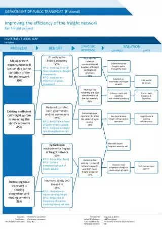
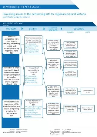
Navigation benefits • Perspectives: • What can Lake Superior regulation affect? • What shipments could reduce costs the most for the least change in water levels? • Which water levels affect costs? • Analysis
Nav Benefits of Current Alternatives Things to notice 1. Almost no difference on costs for shipments below Michigan-Huron because there’s no almost no difference in the levels on Lake Erie or Lake St. Clair
Nav Benefits of Current Alternatives Things to notice 2. Some difference, not a lot, on shipments through the St. Marys River, where regulation plans can make a difference. Notice that preproject and 55Mod 48 are the worst. 3. Plan 130 is the second ranked plan, and not much better than Plan 129, which is ranked 10th.
Analyzing the potential for navbenefits • SVM first slimmed down, removing all calculations outside of commercial navigation • Two plan structure reduced to one plan • Several variations on CN Subroutes worksheet defined to find when, where and why costs went up
CN SubRoutes calculates cost for each trip category each month by finding the controlling depth for that month, then looking up the cost for that depth on CN Costs East dock does just on of the many things CN SubRoutes does, it calculates the depth of water at the eastern dock for each trip category each month. Conn Channel finds the connecting channel depth Conn Channel finds the connecting channel depth And then cause looks at all three and fingers the body of water that was the shallowest along each trip. All the “Ds” here represent Lake Superior. Of course, these are trips on just Lake Superior, so that’s no surprise.
Here are trips between Lakes Michigan-Huron and Lake Superior showing both Cs (Michigan-Huron) and Ds (Lake Superior). What you don’t see are lot of Ls, Ms or Ns (SW Pier, US Slip, and Rock Cut)
Incr Costs calculates the difference between the costs each month, each trip and the lowest possible cost for that trip and month. The minimum costs are calculated on “Min Costs”.
Putting it together • Knowing for each month and trip category which body of water limits loading can provide a statistical portrait of what’s driving costs Violet shading indicates routes affected by Lake Superior or St. Marys River
Putting it together • Loads for trips from Lake Superior to Michigan-Huron are affected most often by depths at the Lake Michigan dock, then the Lake Superior dock, and some at the SW Pier (not much at U.S. Slip or Rock Cut) Violet shading indicates routes affected by Lake Superior or St. Marys River
Putting it together • There aren’t many trips to or from Lake St. Clair • There are many trips between Lake Superior and Lake Erie (these include trips beyond Erie),most limited by Lake Superior or Lake Erie dock depths. Again, some at SW Pier, not many at US Slip or Rock Cut. Violet shading indicates routes affected by Lake Superior or St. Marys River
Best and worst navigation years • In the 109 years of simulated 77A water levels, navigation costs range from $2,816,290,162 to $2,955,652,867, a difference of 5%. • That includes shipments that go through the St Marys and those that do not. • Does a good navigation year mean Lake Superior was high? St. Marys River flows were high?
Cost and level correlations • Ranked each year – average water levels in Superior, MH, flows in St Marys and Costs. • Rank 1 = highest for water, lowest for costs • Best year was 1988, worst year was 1966
Cost and level correlations St. Marys rank vs. Cost Rank Some high flow years have low costs And some have high costs Some low flow years have high costs And a couple low flow years have low costs Highest flows (1) bottom R2 = 0.19 Lowest cost year (1) left
Cost and level correlations St. Marys rank vs. Cost Rank Superior rank vs. Cost Rank R2 = 0.19 R2 = 0.71
Cost and level correlations St. Marys rank vs. Cost Rank Superior rank vs. Cost Rank R2 = 0.19 R2 = 0.71 MH vs. Cost Rank R2 = 0.97