Download
1 / 11
110 likes | 293 Vues
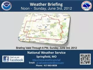
Weather Briefing Winter Weather Today - Wednesday. NWS Peachtree City, Georgia January 28, 2014. Current Warnings/Advisories. Overnight Changes: Winter Storm Warning expanded further north into Atlanta Metro Winter Weather Advisory for most of extreme north GA. Winter Weather Advisory.

E N D
Weather BriefingWinter Weather Today - Wednesday NWS Peachtree City, Georgia January 28, 2014
Current Warnings/Advisories Overnight Changes: • Winter Storm Warning expanded further north into Atlanta Metro • Winter Weather Advisory for most of extreme north GA Winter Weather Advisory Winter Storm Warning Ice Storm Warning
Uncertainties– Dry Air at Surface • As an example – here is the hourly weather graph for ATL • Other sites have similar temperature/dewpoint trends • VERY dry air at the surface • Precipitation will not reach the ground until near-surface air is saturated (RH around 80%)
Uncertainties– P-type Transition • Shaded area starts as sleet/freezing rain • Transition to snow sometime after midnight
Winter Storm Total Forecast Amounts Freezing Rain Snow / Sleet • Sleet will impact storm total snowfall. More sleet = lower snow amounts. **Potential exists for bands of heavier snow to produce isolated amounts higher than shown**
Precipitation Type Expected • Snow expected further north • Dry snow • High snow ratios • Not good for snowballs! • Sleet and freezing rain expected across southeast sections • Significant impacts will be felt from this storm system
Temperatures Today Temperature - Noon Temperature – 8pm Temperature - Midnight • Notice that high temperatures occur in the early morning. • Temperatures will be below freezing area wide by evening when precipitation is ongoing.
Temperatures – Tonight through Thursday Lows Tonight Wednesday Highs Lows Thursday AM • Hard Freeze Wednesday and Thursday mornings • Temperatures rebounding to slightly above freezing Wednesday afternoon • Where sun comes out, some melting on roads will occur, but it will refreeze overnight.
Summary • Significant travel problems across much of central and north Georgia • Caution strongly advised for this afternoon rush hour • Snow will have begin sticking by then • Leave work early if you can to avoid the rush + wintry precip combination!!!! • Heaviest snowfall amounts continue to appear likely in a SW to NE band in the area between Macon and Atlanta Metro. • Southeast portion of the area can expect significant icing from freezing rain – will likely led to some power outages