Download
1 / 24
250 likes | 264 Vues
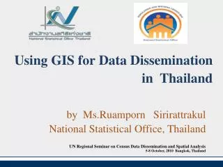
Using GIS for Data Dissemination in Thailand. by Ms.Ruamporn Sirirattrakul National Statistical Office, Thailand. UN Regional Seminar on Census Data Dissemination and Spatial Analysis 5-8 October, 2010 Bangkok, Thailand. Outline. Introduction to Population and Housing Census

E N D
Using GIS forData Dissemination in Thailand by Ms.Ruamporn Sirirattrakul National Statistical Office, Thailand UN Regional Seminar on Census Data Dissemination and Spatial Analysis 5-8 October, 2010 Bangkok, Thailand
Outline • Introduction to Population and Housing Census • GIS for Census data dissemination • NSO-GIS System of web map service • Constraint in developing NSO-GIS
Introduction to Population and Housing Census • Conducted every 10 yrs. in the year ending 0 • New round of census is conducted in this year (2010) and now enumerators are collecting census data (Sep-Oct) • Data collection method : -Face to face interview -Telephone interview - Internet - Dropping questionnaire ( return by post or come back again to pick up) Personnel : 71,000 (9,000 supervisors , 62,000 enumerators)
The 2010 Population and Housing Census Data Dissemination • Press release • Publication Report: • Preliminary ; 3 months • Advance ; 6 months • Final ; 2011 (province and whole kingdom) • Special analysis report • Thematic map report after completion of field work
Web-based data dissemination Census website at URL http://popcensus.nso.go.th as a mean of census information and data dissemination via internetin which variousproducts of Census results are put on web for viewing ,downloading or printing out such as report , quick tables , quick statistics /indicators Data warehousefor interactive tabulating data. NSO-GIS system for interactive thematic maps display . Census Infoput on web and CD-ROM Micro data ( only 1 % will be released ) Customized data requests as well
GIS for census data dissemination • There are 2 map services on line: • NSO-GISis Statistical Geographic Information System which use GIS and web map /web feature service of OGC standard technology for census and survey data dissemination by thematic map. The Interactive Thematic maps can be selected to display at region level down to sub district level.
GIS for Census Data Dissemination(cont.) 2. Census Infoadapted fromDevInfo technology as well as TPD Info which addressadhoc issues,ie., MDG , poverty (Table , Graph and Map ).
NSO-GIS (Statistical Geographic Information System ) • NSO-GIS was developed in 2009 by outsourcing • Selected 17 census/survey projects with 197 core indicators were designed for producing web based thematic maps • NSO-GIS web map service was launched on 1 July 2009 • Census and survey data base as well as thematic maps are updated regularly
Architecture of the NSO-GIS System and neighborhood System Manifold IMS MS SQL Server Postgres+PostGIS Manifold System 8.0 enterprise edition
2010 Census Map in NSO-GIS 1.GIS web map service at http://sgis.nso.go.th • Preliminary result : Feb. 2011(after finishing data processing 2 months ) • Final result : 2012 (after finishing data processing 4-5 months) 2. Thematic map report
2010 Census Map in NSO-GIS Most indicators are the same as 2000 Census • Population : No. of population, Non Thai population , Density of population , % of pop. in municipal area, growth rate • Demographic and social characteristics : % of pop. by age group, nationality, religion, marital status, education , occupation ,sex ratio, literacy rate , migration rate, fertility ,etc.
2010 Census Map in NSO-GIS (cont.) • Housing :% of hh. by type of residence material used , availability of clean drinking water and sanitary toilet, type of fuel used , type of ICT used, possession of durable goods • Household and Village : No., size and type of households and no.of village and size
Selection of Population Census Banner Population Census Population and distribution Region Province District Sub District 2000
2000 Population Density (Province) Density of population Population % of pop.in municipal area
Example of stat GIS Meta data inNSO-GIS Population and Housing Census
Searchingarea with selected data values condition Searching area by province selection Put the total no. of ranking data from Top or Bottom Select indicators
Constraint of developing NSO-GIS • The personnel in charged of GIS for data presentation are statistician so they lack of skill in Thematic mapping and GIS web based administration . • Lack of knowledge on GIS,ICTtechnology, spatial analysis techniques as well as experience in applying GIS with statistical work.
THANK YOU FOR YOUR ATTENTION