Download
1 / 49
490 likes | 627 Vues
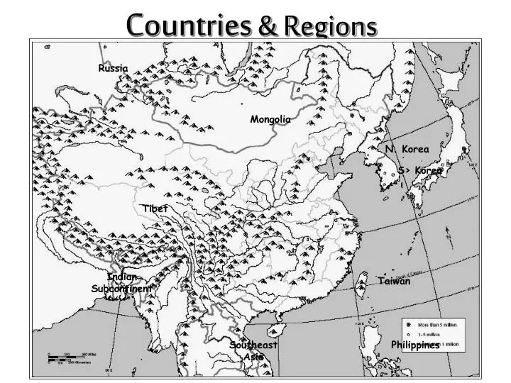
Countries & Regions. Russia. Mongolia. N. Korea. S> Korea. Tibet. Indian Subcontinent. Taiwan. Southeast Asia. Philippines. Cities. Harbin. BEIJING. Nanjing. Shanghai. Xi’an. Lhasa. Taipei. Guangzhou. Hong Kong. Macao. Completed Political Map. Harbin. Mongolia. BEIJING.

E N D
Countries & Regions Russia Mongolia N. Korea S> Korea Tibet Indian Subcontinent Taiwan Southeast Asia Philippines
Cities Harbin BEIJING Nanjing Shanghai Xi’an Lhasa Taipei Guangzhou HongKong Macao
Completed Political Map Harbin Mongolia BEIJING N. Korea S> Korea Tibet Nanjing Shanghai Xi’an Lhasa Indian Subcontinent Taipei Guangzhou Taiwan HongKong Macao Southeast Asia Philippines
Mongolian Plateau Taklimakan Desert Gobi Desert Plateau of Tibet Pacific Ocean Himalaya Mountains North, South , East, West Natural barriers isolated China from all other civilizations.
Physical Geography of East Asia (Fig. 11.6) Globalization & Diversity: Rowntree, Lewis, Price, Wyckoff
PHYSIOGRAPHY Globalization & Diversity: Rowntree, Lewis, Price, Wyckoff
Comparing Size & Latitude Globalization & Diversity: Rowntree, Lewis, Price, Wyckoff
Population Free Powerpoint template from www.brainybetty.com
CLIMATECOMPARISON Globalization & Diversity: Rowntree, Lewis, Price, Wyckoff
Cold Warm Globalization & Diversity: Rowntree, Lewis, Price, Wyckoff
Dry Wet Globalization & Diversity: Rowntree, Lewis, Price, Wyckoff
Bodies of Water Amur River Sea of Japan Yellow Sea Huang-He River Yangtze River Xi River Pacific Ocean SouthChinaSea
River systems • Huang He (Yellow) -Named due to yellow • silt the river carries • Chang Jiang (Yangtze) • Longest river in Asia - Major trade route since ancient times • Xi Jiang (West River) • Runs in South China
Valleys / Plains / Basins Manchurian Plain North China Plain Tarim Basin Sichuan Basin
Agricultural Regions in China Great Wall Shabdong Peninsula Grand Canal CHUNG KUO
“Brown” China vs. “Green” China Wheat Dominant Pasture and Oasis Rice Dominant Double-crop rice • SOURCE: Topic 5: “The Awakening Giant” by Dr. Jean-Paul Rodrigue, Dept. of Economics & Geography, Hofstra University.
Mountains & Peaks Altai Mts. Greater Khingan Tian Shan Kunlun Shan Himalayan Mts.
Even though much of China is covered with mountains, much of the land is inhabited.
Physical Regions of Central Asia (Fig. 10.5) Globalization & Diversity: Rowntree, Lewis, Price, Wyckoff
Tibetan Plateau • In the southwestern part of Outer China • Also known as the Tibet-Qinghai Plateau • Covers about ¼ of China • Rocky land surrounded by towering mountains • Since it’s so high, the climate is very cold and the air is thin and dry • Natural vegetation consists of sparse scrubs and grasses • Antelopes and yaks roam the area
Tibetan Plateau • Dry, desolate region punctuated by mountains and isolated lakes • Embraces the Himalayan Mountains, the Kunlan Mountains, and the Tahseh Shan Mountains
Deserts & Plateaus Gobi Desert Taklamakan Desert Tibetan Plateau
China Satellite View Gobi Desert Tian Shan Taklimakan Desert Kunlun Shan Tibetan Plateau Himalaya