Download
1 / 42
430 likes | 650 Vues
FLASH FLOODS: DEFINING AND FORECASTING. Matt Kelsch 28 & 30 June 2000 kelsch@ucar.edu For more detailed flash flood presentations: www.comet.ucar.edu/class/index.html for more information on the Fort Collins flash flood and a detailed case summary with links:

E N D
FLASH FLOODS: DEFINING AND FORECASTING Matt Kelsch 28 & 30 June 2000 kelsch@ucar.edu For more detailed flash flood presentations: www.comet.ucar.edu/class/index.html for more information on the Fort Collins flash flood and a detailed case summary with links: www.comet.ucar.edu/resources/cases/c11_28jul97/lab1.htm for a link to our Venezuela flash flood and landslide page: http://www.comet.ucar.edu/resources/cases/venezuela/index.htm
FLASH FLOODS: DEFINING AND FORECASTING What Are They? What is the correlation with precipitation amount? What is the correlation with precipitation rate? How important is the hydrology?
Flash Floods: Defining and Forecasting Precipitation • Intensity • Duration Hydrologic Response • Natural Basin Hydrology • Altered Basins Flash Flood forecasting requires more than accurate forecasts of excessive accumulation
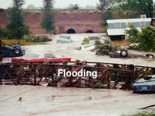
Defining the Flash Flood A flash flood is a situation where the causative precipitation and the subsequent runoff are occurring on the same scales. • Intense Precipitation • Small, Fast-response basins
Flash Flood Warnings Flash Floods lack objective definition and verification There isn’t a reliable correlation between rainfall amount and flash flood severity. Severe weather occurs first, if both occur in the same storm.
Issues With Flash Flood Warnings Improvements to the Flash Flood Watch stage have occurred since the 70’s What about Warnings? 1) In an attempt to make sure everyone in the threat area is warned, long-duration warnings are issued for large areas
Issues With Flash Flood Warnings 2) In a conscientious attempt to provide specific detail in space and time, there is little or no lead time
Common Features of Flash Floods Precipitation • Accumulation: 50-500 mm over 1-12 h • Duration of causative precipitation mostly <3 h • Intensity 75-300 mm/h • Arid/semi-arid climates 75-200 mm/h (avg 118 mm/h) • Humid climates 125-300 mm/h (avg 192 mm/h)
Common Features of Flash Floods Basin Characteristics • Small 10-125 km2 (avg 46 km2) • 70% mountainous watersheds • >50% were altered • Urbanization • Deforestation, fire scars • Either thin/impermeable surface layer, • Clay, rocks (low infiltration) • Pavement (no infiltration) • Or, thick, saturated soil layers
0500 UTC 7 Aug 1999 0700 UTC 7 Aug 1999
KLOT (Chicago) Radar Storm Total Accumulation as of 1400 UTC 18 July 1996
Precipitation Intensity Enhanced Precipitation Efficiency • Moist ambient environment with relatively weak shear (little entrainment of dry air) • Deep above freezing cloud layer: ~4 km • Well-defined high-einflow (low-level jet) • High Precipitable Water values (30-50 mm) • Low-centroid storms, warm rain process • Enhanced low-level lift (orographic or meteorological boundary)
5:30 8:00 8:30 9:00 9:40 10:30 11:00 1:20 Rain begins EOC Activated Ponds Overflowing, rapid water rescues begin Most intense rain commences NWS Warning Storm begins to dissipate and move northeast Trailer Park Flooding, Fires, Train Derailment Declared City Disaster Timetable of Flood Events
Flash Floods: Defining and Forecasting Precipitation Intensity Tropical Maritime Connection Deep above-freezing cloud layer (4 km) • Atypical precipitable water: 25 (arid)–50 mm • Low-level jet, high e air • Extra low-level lift associated with a boundary ** beware of storm-specific enhancement
Flash Floods: Defining and Forecasting Fast-Response Basins Small Size • 10-125 km2 (avg 46 km2) • Many <40 km2 Thin, impermeable soil or; deep, saturated soils Altered Basin Hydrology • Urbanized • Fire Scar