Download
1 / 31
390 likes | 788 Vues
LIDAR vs Photogrammetry?. Lewis Graham GeoCue Corporation 9668 Madison Blvd., Suite 202 Madison, AL 35758 256-461-8289 lgraham@geocue.com www.geocue.com. The Fight is On!!. Nomenclature - DSM. First Reflectance Surface. Nomenclature - DTM. “Bare” Earth. Why LIDAR?.

E N D
LIDAR vs Photogrammetry? Lewis Graham GeoCue Corporation 9668 Madison Blvd., Suite 202 Madison, AL 35758 256-461-8289 lgraham@geocue.com www.geocue.com
The Fight is On!! Ohio UAS Test Center - LIDAR vs Photogrammetry
Nomenclature - DSM First Reflectance Surface Ohio UAS Test Center - LIDAR vs Photogrammetry
Nomenclature - DTM “Bare” Earth Ohio UAS Test Center - LIDAR vs Photogrammetry
Why LIDAR? • The original primary goal was to directly collect accurate digital elevation data at very high speeds • Primary initial goal was rapid/accurate floodplain mapping • Since its inception, the role of LIDAR has expanded to include: • LIDAR “Images” for direct true ortho generation • Extraction of data that is very difficult via photography (e.g. Transmission Line modeling) • Building extraction • 3D asset collection • General purpose mapping Ohio UAS Test Center - LIDAR vs Photogrammetry
Why PCDSM?(Photo-Correlated Digital Surface Models) • The original primary goal was to automatically derive accurate digital elevation data at very high speeds • Primary driver was “one source” orthophoto generation • Since its inception, the role of PCDSM has expanded to include: • 3D Visualization • Building extraction • 3D asset collection • General purpose mapping Ohio UAS Test Center - LIDAR vs Photogrammetry
iSTAR True Ortho (1999) Ohio UAS Test Center - LIDAR vs Photogrammetry
Photo-Correlated Digital Surface Models Ohio UAS Test Center - LIDAR vs Photogrammetry
High X, Y Spatial Resolution Ohio UAS Test Center - LIDAR vs Photogrammetry
But Axial Depth is Derived At least two images from different locations must see the same object space point Ohio UAS Test Center - LIDAR vs Photogrammetry
Spatial Filtering by Design Ohio UAS Test Center - LIDAR vs Photogrammetry
Correlation Noise Ohio UAS Test Center - LIDAR vs Photogrammetry
Voids Trees Voids Robert Bussard Occlusion, shadows, other correlation failures Ohio UAS Test Center - LIDAR vs Photogrammetry
Eyeball Aliasing PCDSM – Color by Z PCDSM - RGB Ohio UAS Test Center - LIDAR vs Photogrammetry
No Ground… Ohio UAS Test Center - LIDAR vs Photogrammetry
LIDAR Ohio UAS Test Center - LIDAR vs Photogrammetry
LIDAR directly measures X, Y ,Z(sort of…) Ohio UAS Test Center - LIDAR vs Photogrammetry
Only a single ray required Ohio UAS Test Center - LIDAR vs Photogrammetry
Modern LIDARs can detect Multiple Returns & Waveform Ohio UAS Test Center - LIDAR vs Photogrammetry
Laser Return Intensity Corridor mapper 1.541 microns Wide area mapper 1.064 microns Ohio UAS Test Center - LIDAR vs Photogrammetry
Optech Gemini Ohio UAS Test Center - LIDAR vs Photogrammetry
Aliasing is common Spatial filtering must be configured by the operator - Usually not understood/considered in flight planning Ohio UAS Test Center - LIDAR vs Photogrammetry
Comparing correlators Ohio UAS Test Center - LIDAR vs Photogrammetry
~50 Image Mosaic Ohio UAS Test Center - LIDAR vs Photogrammetry
Comparing Contours Lower Noise Higher Noise Ohio UAS Test Center - LIDAR vs Photogrammetry
Flat surface noise Ohio UAS Test Center - LIDAR vs Photogrammetry
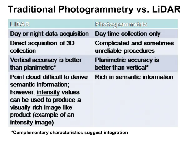
LIDAR vs PCDSM Ohio UAS Test Center - LIDAR vs Photogrammetry
Comparison Factors LIDAR Ohio UAS Test Center - LIDAR vs Photogrammetry
Optimal Uses LIDAR (1) Excellent if completely illuminated. Poor in shadows (2) Both have advantages/disadvantages. We are investigating. Ohio UAS Test Center - LIDAR vs Photogrammetry
And the winner is… There is no winner. They are completely different technologies with little overlap in applicability Ohio UAS Test Center - LIDAR vs Photogrammetry
Thank You! Ohio UAS Test Center - LIDAR vs Photogrammetry