Download
1 / 11
110 likes | 274 Vues
The VSIMS Atlas Project. VSIMS Atlas. Bill Thorp - Developer, CSU/NPS NRGIS. VSIMS Atlas. What is VSIMS? What is the VSIMS Atlas? VSIMS vs. VSIMS Atlas The Challenges of a Public Audience The Challenges of Everyday I.T. Portability as Innovation Technical Mumbo-Jumbo

E N D
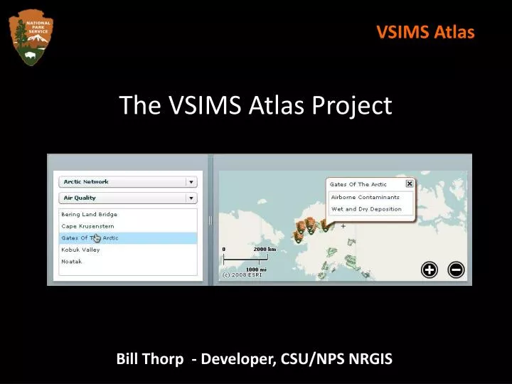
The VSIMS Atlas Project VSIMS Atlas Bill Thorp - Developer, CSU/NPS NRGIS
VSIMS Atlas • What is VSIMS? • What is the VSIMS Atlas? • VSIMS vs. VSIMS Atlas • The Challenges of a Public Audience • The Challenges of Everyday I.T. • Portability as Innovation • Technical Mumbo-Jumbo • The Future : Enterprise Systems • Questions?
VSIMS Atlas What is VSIMS? • Vital Signs Internet Mapping Service • Designed for NPS internal usage • Complex features • Can visualize and query individual monitoring datasets • Runs on ASP.NET / ArcIMS / SQL servers • Sensitive and protected data • Stand-alone web application
VSIMS Atlas What is the VSIMS Atlas? • VSIMS Atlas • Designed for public use • Simple features • Simply tells what monitoring is happening at what parks • Runs on any HTML web server • Non-sensitive and unprotected data • Embeddable into your web pages • http://science.nature.nps.gov/nrgis/atlas
VSIMS Atlas VSIMS vs. VSIMS Atlas • VSIMS • Designed for functionality • On-the-fly imagery • Query / visualize datasets • ATLAS • Designed for portability • Tiled imagery • Lists of monitoring datasets
VSIMS Atlas The Challenges of a Public Audience • Potentially large number of users • Usage spikes / multiple simultaneous users • Limited feedback mechanisms • Accustomed to Google Maps, not ArcIMS / ArcGIS Server • Speed and usability trump complex content • Needs to be highly fault tolerant • Needs to play well with any system (CMS, etc)
VSIMS Atlas The Challenges of Everyday I.T. • Mapping complex “live” data is inherently a complex, slow process • VSIMS uses separate servers for ASP.NET, SQL Server, ArcIMS, and ArcSDE • These servers requires periodic downtime / maintenance • High-cost “enterprise” systems use redundancy -- not an option for NRGIS internally
VSIMS Atlas Portability as Innovation • Leverage pre-rendered tiled imagery instead of drawing maps on-the-fly • Leverage XML and “smart” XML-parsing clients instead of SQL databases • Leverage compressed XML for speed • Designed to run from any web server • Embed in Network, program web pages • NO NRPC HARDWARE / SOFTWARE TIES • Portable solutions -> “enterprise” systems
VSIMS Atlas Technical Mumbo-Jumbo • Uses free OpenStreetMap background tiled imagery • Overlays custom NPS Boundary Layer tiles created using TileCache • Park data from a SQL database at NPS, but has an XML “snap-shot” compressed and saved • Atlas client written in Adobe Flash • Excellent XML processing capabilities • Supports compressed data
VSIMS Atlas The Future : Enterprise Systems • Creating the VSIMS Atlas as a portable application offers us flexibility in how we deploy it, and offers room to grow… • Easy to deploy to multiple systems / servers • Promote to nps.gov or eGIS servers • Commercial, enterprise-level servers: • AKAMAI / Amazon S3
VSIMS Atlas Questions?