Download
1 / 37
380 likes | 715 Vues
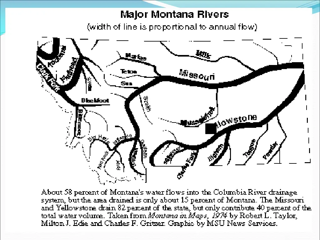
The Clark Fork River. Approximately 360 mi (579 km) long. The largest river by volume in Montana, it drains an extensive region of the Rocky Mountains in western Montana and northern Idaho in the watershed of the Columbia River .

E N D
The Clark Fork River • Approximately 360 mi (579 km) long. • The largest river by volume in Montana, it drains an extensive region of the Rocky Mountains in western Montana and northern Idaho in the watershed of the Columbia River. • Flowing northwest through a long mountain valley and emptying into Lake Pend Oreille in northern Idaho.
The Kootenai River • Is the uppermost major tributary of the Columbia River. • Flowing through British Columbia, Montana and Idaho. • It one of the few rivers in North America which begins in Canada, enters the United States and then reenters Canada.
Flathead Lake • Largest freshwater lake west of the Mississippi River. • Located south of Kalispell. • Popular resort lake for many Montanans and tourists.
The Jefferson River • Is a tributary of the Missouri River, approximately 207 miles long. • It is one of three rivers, along with the Madison and Gallatin that converge near Three Forks, Montana to form the Missouri. • Named by Lewis and Clark after President Thomas Jefferson.
The Madison River • Is a tributary of the Missouri River, approximately 183 miles long. • It starts in Yellowstone Lake. It flows west then north through the mountains of southwestern Montana to join the Jefferson and Gallatin rivers at Three Forks to form the Missouri River. • The river was named by Lewis and Clark in July 1805, for US Secretary of State James Madison
The Gallatin River • Is a tributary of the Missouri River, approximately 120 mi. long. • It stars in Yellowstone It flows northwest through Gallatin National Forest, past Big Sky, Montana, and joins the Jefferson and Madison approximately 30 mi northwest of Bozeman. • The river was named by Lewis & Clark for Treasury Secretary Albert Gallatin.
The Sun River • Is a tributary of the Missouri Riverin the Great Plains, approximately 130 mi. long. • The water of the river is used extensively for irrigation, through the Sun River Project of the United States Bureau of Reclamation. The irrigation area covers approximately 92,000 acres
The Marias River • Is a tributary of the Missouri River, approximately 210 mi. long. • The river was explored in 1805 by the Lewis and Clark expedition, who mistook it for the main branch of the Missouri until their subsequent discovery of the Great Falls of the Missouri near Great Falls, Montana. The river was named by Meriwether Lewis after his cousin, Maria Wood.
The Milk River • Is a tributary of the Missouri River, 729 mi. long. • The Milk is the northernmost major tributary of the Missouri. • The Milk river was given its name by Captain Lewis, of the Lewis and Clark Expedition, who described the river in his journal: • "the water of this river possesses a peculiar whiteness, being about the colour of a cup of tea with the admixture of a tablespoonfull of milk. from the colour of its water we called it Milk river."
The Missouri River • Is a tributary of the Mississippi River and is the longest river in the United States. • The Missouri begins at the confluence of the Madison, Jefferson, and Gallatin rivers in Montana (the “Three Forks”), and flows into the Mississippi north of St. Louis, Missouri. • At about 2,341 mi (3,725 km) in length, it drains approximately one-sixth of the North American continent.
The Musselshell River • Is a tributary of the Missouri River, approximately 292 miles long, in central Montana. • The river flows across the Great Plains and is used extensively for irrigation.
The Yellowstone River • Is a tributary of the Missouri, approximately 692 mi • Considered the principal tributary of the upper Missouri, the river and its tributaries drain a wide area stretching from the Rocky Mountains in the vicinity of the Yellowstone National Park across the mountains and high plains of southern Montana and northern Wyomingbefore flowing into the Missouri River near Buford, North Dakota. • It is the longest undammed river in the lower 48 states.
The Bighorn River • Is a tributary of the Yellowstone, approximately 461 mi long. • At the border with Montana, the river turns northeast, and flows past the north end of the Bighorns, through the Crow Indian Reservation, where the Yellowtail Dam forms Bighorn Lake.
The Tongue River • Is a tributary of the Yellowstone, approximately 265 mi. long, • It forms the eastern boundary of the Northern Cheyenne Indian Reservation. • It joins the Yellowstone near the town of Miles City.
The Powder River • Is a tributary of the Yellowstone River, approximately 375 mi (603 km) long in the southeastern Montana. • The Powder River was so named because the sand along a portion of its banks resembled gunpowder. • Has been described as “a mile wide and an inch deep, too thin to plow and too thick to drink.”
Fort Peck Reservoir • The fifth largest man-made lake in the U.S. • Formed by the Fort Peck Dam. • The dam and 134-mile long lake exist for the purposes of hydroelectric power generation, flood control, and water quality management.
Yellowstone National Park: Lower Yellowstone Falls on the Yellowstone River; Fishing Bridge on the Yellowstone River near Lake Yellowstone.
What to include on your Montana map: • All counties & county seats; all 7 reservations • Rivers: Clark Fork, Kootenai, Marias, Milk, Musselshell, Missouri, Yellowstone, Bighorn, Tongue, Powder, Jefferson, Madison, Gallatin, Sun; also Flathead Lake and Ft. Peck Reservoir • Yellowstone & Glacier National Parks • Mountains: Bitterroots, Bear’s Paw, Rockies, Continental Divide, Bighorns