Download
1 / 24
270 likes | 495 Vues
Lidar remote sensing for the characterization of the atmospheric aerosol on local and large spatial scale. Aerosols interact both directly and indirectly with the Earth’s radiation budget and climate. Minute particles suspended in the atmosphere.

E N D
Lidar remote sensing for the characterization of the atmospheric aerosolon local and large spatial scale
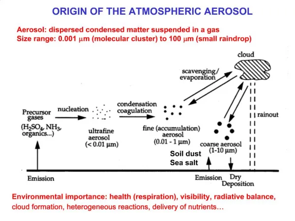
Aerosols interact both directly and indirectly with the Earth’s radiation budget and climate Minute particles suspended in the atmosphere Aerosols modify the size of cloud particles, changing how the clouds reflect and absorb sunlight Aerosols reflect or absorb sunlight MOTIVATION Atmospheric aerosol What are THEY and why are THEY so important? WHAT ABOUT THEESTIMATION OF THEIR EFFECTS?
MOTIVATION from Intergovernmental Panel Climate Change
Mie scattering Rayleigh scattering I ~ l-4 x << 1 Mie scattering, larger particles Rayleigh scattering Mie scattering molecules Direction of incident light sA ~ 10-3 sE Raman scattering Information on the species concentration INTERACTION LIGHT - ATMOSPHERE • Elastic scattering • Anelastic scattering
Receiver Signal processing THE REMOTE SENSING LIDAR TECHNIQUE LIght Detection And Ranging Sorgente laser Nd-Yag Laser
1 equation 2 unknown parameters + a priori hypothesis Lidar Ratio (LR) ELASTIC LIDAR EQUATION (SINGLE SCATTERING) z: altitude l: wavelength PL: laser power x: efficiency vertical resolution acceptance angle β = βm+βa backscatter coefficient Standard Atmosphere a = am + aa extinction coefficient
RAMAN LIDAR EQUATION (SINGLE SCATTERING) 1 Elastic lidar equation + 1 Raman lidar equation 2 unknown parameters No a priori hypothesis
RCS - RANGE CORRECTED SIGNAL = P(z)*z2 RCS @ 532 nm (a.u.) Naples, 9-10 May 2005 Planetary Boundary Layer 7000 Directly influenced by the presence of the Earth's surface Height above lidar station (m) 6000 5000 4000 3000 PBL height 2000 1000 Aerosol as tracers 18:00 20:00 22:00 24:00 02:00 04:00 06:00 Time (UT)
Naples station (40.833°N, 14.183°E, 118 m. asl) EARLINET (European Aerosol Research LIdar NETwork) Since May 2000 • regular measurements twice a week • special measurements (Saharan dust, • forest fires, volcanic eruption, etc…) • intercomparison • both for hardware and software 25 stations ARPAC
THE NAPLES LIDAR SYSTEM 387 High 387 Low Collimating Lens 387 407 407 387 407 532 355 Diaphragm 355 > 532 355 High 355 Low 532 607 532 High 532 Low 607
cloud PRE - PROCESSING DATA CLOUD SCREENING Sharp variation 1011 1010 RCS (a.u.) 109 108 0 5000 10000 15000 20000 Height (m)
Rate D1 (MHz) Rate D2 (MHz) PRE - PROCESSING DATA PILE UP CORRECTION Measure the same signal: - D1 at low acquisition rate (< 500kHz) - D2 at working condition Polinomial fit
PRE - PROCESSING DATA MERGE 1011 Analog – low height 1010 Photocounting – high height RCS (a.u.) 109 108 0 5000 10000 15000 20000 Height (m)
PRE - PROCESSING DATA CALIBRATION 1011 1010 “Clean” air RCS (a.u.) 109 Molecular signal 108 0 5000 10000 15000 20000 Height (m)
Depolarization measurement Why? Function of the particles’ morphology Identification of solid and liquid phases of the particles
How do we perform linear depolarization measurements? • Use a linearly polarized laser source • Align a detecting channel (P channel) in the same direction of the initial polarization of the laser • Align another detecting channel (S channel) orthogonal with respect to the laser initial direction of polarization • Calibration of the system
Total Depolarization coefficient Defined as: Is the backscattering coefficient S(z) and P(z) are the ortoghonal and parallel signals H is the calibration constant k takes into account the instrumental effects
Aerosol Depolarization coefficient Molecular depolarization (0.00376) R Backscatter ratio Total depolarization coefficient
How do we calibrate depolarization channels? The calibration constant measures the relative efficiency of the polarization channels. There were studied and evaluated 4 techniques: • Rayleigh method • 90° rotation of the polarization of the laser • 45° rotation • Depolarization