Download
1 / 32
360 likes | 622 Vues
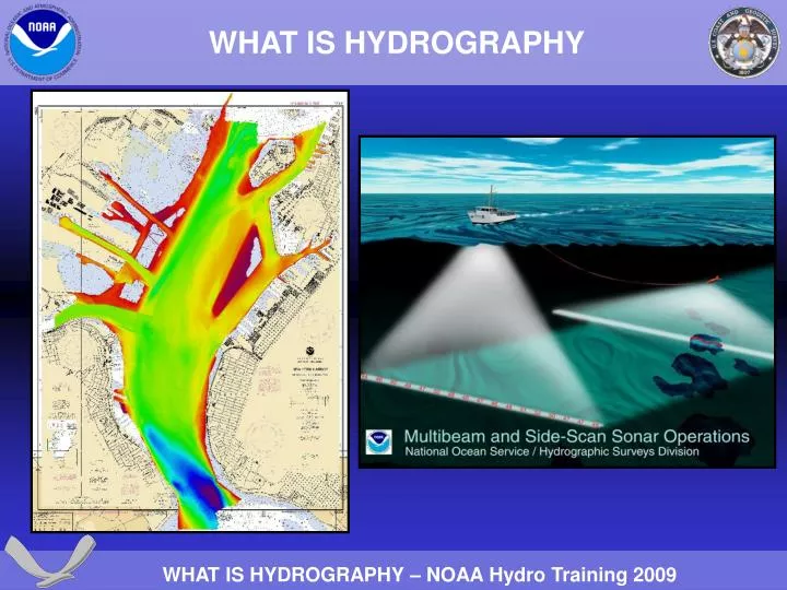
WHAT IS HYDROGRAPHY. WHAT IS HYDROGRAPHY. Hydrography is the science of measuring and depicting those parameters that are necessary to describe the precise nature and configuration of the sea-bed its geographical relationship to the landmass the characteristics and dynamics of the sea .

E N D
WHAT IS HYDROGRAPHY Hydrography is the science of measuring and depicting those parameters that are necessary todescribe • the precise nature and configuration of the sea-bed • its geographical relationship to the landmass • the characteristics and dynamics of the sea. • The parameters encompass bathymetry, geology, geophysics, tides, currents, waves, and certain other physical properties of sea water • Hydrographic surveying is the art of collecting hydrographic data utilizing a skillful blend of systems and field methodologies. Not something which can be learned in a classroom! (USM and UNB Intro to Hydrography, GGE1001)
THREE ASPECTS Coastal hydrography is concerned with the development of ports and harbours, coastal erosion problems, the utilization of harbour and coastal conservation services and, especially, the safety of navigation in coastal waters. Off-shore hydrography is concerned with (a) the provision of hydrographic data as an extension of the coastal zone normally encompassing the continental shelf, (b) the development of mineral deposits, including hydrocarbons, and (c) provision of data for fisheries management. Oceanic hydrography is concerned with the acquisition of hydrographic data in the deep ocean areas for the depiction of sea-floor geomorphology. (USM and UNB Intro to Hydrography, GGE1001)
2001 New Definition of Hydrography • Hydrography is the total set of spatial data and information, and the applied science of its acquisition, maintaining and processing, necessary to describe the topographical, physical and dynamical nature of the hydrosphere and its borders to the solid earth, and the associated facilities and structures. • Task: data acquisition (but not just bathymetry) • Purpose: distributing information (for informed decision making), rather than constructing products. • Horst Hecht, Federal Maritime and Hydrographic Agency of Germany (Bundesamt für Seeschiffahrt und Hydrographie), May 2001: (USM and UNB Intro to Hydrography, GGE1001)
Coast Water level lining measurements Shore control Data acquisition Echo Geophysical sounding measurements Positioning Sweep coverage (USM and UNB Intro to Hydrography, GGE1001)
Depth measurement types (USM and UNB Intro to Hydrography, GGE1001)
NOAA Hydrographic Fleet RAINIER Seattle, WA 1968 S/V BAY HYDROGRAPHER Solomons, MD FAIRWEATHER Ketchikan, AK 1968, (2004) NRT’s – 6 teams Nationwide THOMAS JEFFERSON Norfolk, VA (1992) NOAA’s Ocean Service
A Brief History of NOAA Hydrography • Ferdinand Hassler appointed first superintendent of the Survey of the Coast in 1816, when first survey work began. (First soundings were not collected until 1834!). • During the Civil War, all CS resources used to support the war effort (earliest roots of NOAA Corps….commissioned officers needed to lead field parties because survey parties were attached to various Army and Navy commands. All Navy officers were used in the war effort, so officer status was given to civilians who were leading survey parties.).
A Brief History of NOAA Hydrography • In 1917 (during WWI), the U.S. Coast and Geodetic Survey commissioned officer corps was created as Army and Navy officers were used in the war effort. • WWII: USC&GS used to survey South Pacific Islands in advance of Marine landings, etc (hostile fire). • In 1966, USC&GS was assimilated into a new agency called ESSA, along with the National Weather Bureau. • In 1970, ESSA was combined with the Bureau of Commercial Fisheries, Environmental Data Service, National Satellite Center, and Research Libraries, to create NOAA. USC&GS became the National Ocean Service. • 1982: Office of Charting and Geodetic Services. 1991: U.S. Coast and Geodetic Survey. 1994: Office of Coast Survey.
Hydrographic Data Types Bathymetry : “measure of the deep,” data provides depth contours of the bottom surface. • “X,Y” = positioning data from Global Positioning System (GPS) • “Z” = sounding data from echosounder. Measures depth of water by time it takes for sound to transmit and return to transducer. • Time = data used to correct for water level (tide) at time of data collection Features: data points, lines, and areas acquired to delineate natural and man-made charted features.
SAFE NAVIGATION National Spatial Reference System Nautical Charts Tides and Currents Hydrographic Surveys Research and Development Models and New Technologies
Historical Perspective • 98% by tonnage of all U.S. commerce • 45% by value (about $500 billion) • 50% is hazardous materials
Size of vessels Ships now are limited by height, draft, and width of channel.
Homeland Security • The Nations ability to quickly respond to an intelligence report that a mine has been laid on the bottom of a major U.S. harbor is critical to the continuous flow of maritime commerce. • If a threat condition occurred, the Navy will use the survey data as a baseline of pre-existing objects so they can utilize their mine counter-measure assets more effectively to determine if a mine has been placed on the seafloor.
Underwater Port Security • NOAA Hydrographic Ships and Navigation Response Teams have the specialized capability to collect high resolution imagery of shipping channels. • The Oceanographer of the Navy requested NOAA to provide side scan sonar imagery of shipping channels and harbors to NAVO. • NOAA collected data at 34 strategic commercial ports. • NAVO collected data at 14 military ports. • NAVO to process and store data. Klein 5000 Side Scan Sonar Detailed Side Scan Sonar Imagery
Critical Areas and Priorities • Defined by apparent risk of incident due to: • Volume, density of traffic, and UKC in relation to bottom type • Age/adequacy of surveys • Petroleum or HAZMAT transport through region • Requests from maritime interests; i.e. USCG, Pilots’ Associations, Port Authorities, etc. • Approximately 30,000 SNM critical area remaining nationwide • NOAA, through ships and contractors, survey approximately 1300 - 1600 SNM/year with existing resources and funding levels
NOAA Hydrographic Fleet RAINIER Seattle, WA (1968) S/V BAY HYDROGRAPHER Solomons, MD FAIRWEATHER Ketchikan, AK 1968, (2004) NRT’s – 6 teams Nationwide THOMAS JEFFERSON Norfolk, VA (1992) NOAA’s Ocean Service
Other Hydro-capable NOAA vessels GLORIA MICHELLE NANCY FOSTER OSCAR DYSON HENRY BIGELOW RONALD BROWN HI’IALAKAI NOAA’s Ocean Service
Shallow Water Multibeam < TABLE>
Phase Differencing Bathymetric Sonar Benthos C3D GeoSwath Klein 5410
Bottom Coverage & Vintage by Survey Method Single Beam Multi Beam Leadline Pre - 1940 1998 - Present 1940 - 1998
NOAA’s Navigation Services: Nautical Charting • Annual Coast Pilot & Weekly Chart Updates • 1000 Paper Charts and Raster Nautical Charts • 998 Print-on-Demand • 380 Electronic Navigational Charts (ENCs) posted on the web • 6 Navigation Response Teams • Additional teams planned
NOAA’s Navigation Services: Navigation Response Teams Electronic Navigation Charts Navigation Response Teams
NOAA’s Ocean Service • ENCs integrated with Coast Pilot data • NRT coverage of the contiguous U.S. • Addressing the survey backlog with new technologies: LIDAR, AUVs, high speed ship launches • Quality Assurance Program • Chart of the Future (UNH Joint Hydrographic Center) • Unmanned Aerial Vehicles (UAV) for Shoreline/Remote Sensing • Streamlining Data Pipeline (survey to chart in 3 mos.)
NOAA’s Office of Coast Survey Critical to an MTS Capable of Supporting U.S. Economic Growth www.noaa.gov