Download
1 / 16
160 likes | 237 Vues
What’s underneath Houston? Faults , salt, & sediments . Li Chang, Ph.D. Student Advisor: Dr. Robert R. Stewart. AGL Research Presentation & Update Meeting 2 nd May, 2012. Outline. Intro of AGL field work Field equipment: Source, receiver and recorder system

E N D
What’s underneath Houston? Faults, salt, & sediments Li Chang, Ph.D. Student Advisor: Dr. Robert R. Stewart AGL Research Presentation & Update Meeting 2nd May, 2012
Outline • Intro of AGL field work • Field equipment: Source, receiver and recorder system • Acquisition design and field parameter • Processing result: Fault, salt, & sediments • Summary • AGL capability & future field work
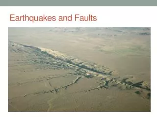
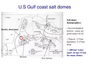
Field work done in “H” town Hockley fault 1075 m H UH ERP 285 m Pierce Junction 955 m UH Coast center 955m (Modified from Engelkemeir and Khan, 2007)
Acquisition design and field parameter Geode #2 Geode #9 Geode #10 Geode #1 OUT IN OUT OUT IN V V V V LOW END LOW END LOW END LOW END IN • Field parameter • Line length : 285~1075m • # of Receiver: 96~240 • Shot interval : 5m, Receiver interval : 5m • Sample rate : 1ms • Record length : 4sec • Vertical Stack :2~3 • Sweep length: 12sec • Sweep type : Linear sweep 10Hz ~150Hz NIB OUT
HockleyFault Premium Outlet Hockley fault dipping Block out due to highway construction 1075m 325m+750m Crack produced by fault?
Hockley Fault Raw shot gather Filtered with (25-35-100-120 Hz)
HockleyFault SE 0 50 150 250 350 450 550 650 750 850 950 1050 (m) 200 400 600 800 1000 (m) Fault? Elevation (GPS)
Pierce Junction saltdome S 0 50 150 250 350 450 550 650 750 850 950 (m) 200 400 600 800 1000 (ms)
ERP-sediments N 0 30 60 90 120 150 180 210 240 270 (m) 500 1000 1500 2000 2500 (m) (ms) Last credible reflector at 1900 m (Processed by ArkadiuszTourolski, 2011 )
UH CoastCenter-sediments 0 100 200 300 400 500 600 700 800 900 (m) 500 1000 1500 2000 2500 3000 (m) 3 times longer than ERP
Summary • The Hockley fault is detected and another fault dipping toward the opposite direction is also found by the processing result • The shot gather shows two strong reflectors consistently during our seismic acquisition which refers to the cap rock and top of salt at Pierce Junction salt dome • Two stack sections from UH ERP and Coast center are the representative sediments in the Houston area
AGL capability & future field work • Geophysical acquisition -Well logging, VSP, Grav & Mag, GPR, 1-C & multicomponent seismic • Surveying & Measuring - V-meter, Blasmate, Total Station and GPS • Capability - Conduct multi-task in one time - Shoot a 1-km seismic line in 2 days - At least 3 software available for processing seismic data • Future work Needvile fault investigation, Hockley fault survey in the night, well perforation and hydro-fraction experiment, seismic expedition in Utah, 4th YBRA geophysical field camp………..at least 6 for the rest of 2012
You are very welcome to join us if ……you think field work is not tough but “fun” Special thanks to Dr. Robert Stewart Faculty at UH AGL crew Penny Maher Laura Bell NSM IT