Download
1 / 1
10 likes | 133 Vues
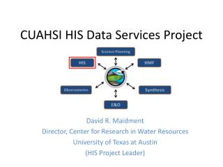
Map Server. Time Series Analyst. Models. Databases. Analysis. HydroServer Website. HydroServer Capabilities Web Service. Hydrologic Information System for the Nation. HydroServer Database Configuration Tool. WaterOneFlow Services. HydroServer Database. Spatial Services. HIS Central.

E N D
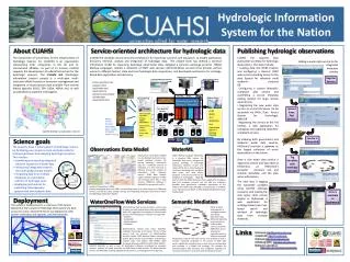
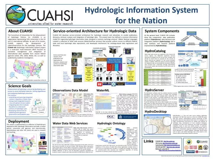
Map Server Time Series Analyst Models Databases Analysis HydroServerWebsite HydroServerCapabilities Web Service Hydrologic Information System for the Nation HydroServerDatabase Configuration Tool WaterOneFlow Services HydroServer Database Spatial Services HIS Central WaterOneFlow WaterOneFlow WaterOneFlow ODM ODM ODM About CUAHSI Service-oriented Architecture for Hydrologic Data System Components ODM Databases and WaterOneFlow Web Services ArcGIS Server Spatial Data Services The Consortium of Universities for the Advancement of Hydrologic Science, Inc. (CUAHSI) is an organization representing 120+ universities in the US and 11 international affiliates. As part of its mission, CUAHSI supports the development of cyberinfrastructure for the hydrologic sciences. The CUAHSI HIS (Hydrologic Information System) project is a multi-year multi-institution effort focused on consistent management and integration of observational data available from several federal agencies (USGS, EPA, USDA, NOAA, etc.) as well as published by academic investigators. CUAHSI HIS develops service-oriented architecture for hydrologic research and education, to enable publication, discovery, retrieval, analysis and integration of hydrologic data. The project team has defined a common information model for organizing hydrologic observation data, designed a common exchange protocol (Water Markup Language), created a collection of SOAP web services (WaterOneFlow services) that provide uniform access to different federal, state and local hydrologic data repositories, and developed mechanisms for ontology-based data registration and discovery. At the general level, CUAHSI HIS includes three key components: data publication platform (HydroServer); data discovery and integration platform (HydroCatalog) and a data synthesis and research platform (represented by HydroDesktop). Global search (Hydroseek) HydroCatalog Customizable web interface (DASH) Other popular onlineclients Water data web services are registered at the Central HIS service registry. The HISCentral application harvests observation metadata from the service (sites, variables, and periods of record that are accessed via the service) at regular intervals and appends it to the central metadata catalog. In addition, HISCentral supports semantic tagging of the registered data, by associating the harvested variables with concepts from a hydrologic ontology. HydroCatalog web services enable data discovery by HIS clients such as HydroDesktop. End-to-end three-tier solution: frompublication and registration to discovery, analysis and synthesis of hydrologic observation data Desktop clients Data publishing Water Data Web Services, WaterML HIS CentralRegistry & Harvester Test bed HydroServers Ontology ETL services Controlled vocabularies Metadatacatalogs HydroDesktop WSDL and ODM registration Number of data requests brokered by the catalog has been growing rapidly Ontology tagging (Hydrotagger) Matlab, IDL, R Rainfall & Snow Catalog content (09/2010): 60+ public services 15,400+ variables 1.8+ million sites 23.3 million series 4.7 billion data values ODM DataLoader ArcGIS Streaming Data Loading External data providers Central HIS servers HIS Lite Servers Excel Soil water Programming (Java, C, VB) Meteorology ODMTools CUAHSI member universities in the US Water quantity and quality Modeling (OpenMI) Server config tools Remote sensing Science Goals Federal agency data services in HISCentral HydroServer • Enhancement of hydrologic science by facilitating user access to more and better data for testing hypotheses and analyzing hydrologic processes • This involves: • assembling and querying integratednations’s repository of water data • linking small integrated research sites with global climate models • integrating data from multiple disciplines to understand controls on hydrologic cycle • developing mechanisms for publishing heterogeneous government and academic data Observations Data Model WaterML WaterML Water Data Web Services Hydrologic Ontology • The HydroServer software stack has enabled individual scientific investigators and research groups to publish their hydrologic observations and make them available within CUAHSI HIS. It is available in two versions: a complete HydroServer suite, which relies on commercially available components, and an HIS Server Lite, composed of freely available components. • To publish hydrologic time series, data managers can use various data loaders to ingest observational data into instances of ODM, perform quality control of the data, configure web services over the ODM databases, and customize an online mapping application for accessing the new data. Observations Data Model (ODM) is a standardized and community-tested relational schema for storing hydrologic observation data and a sufficient amount of metadata, in a form that aids in effective sharing Water Markup Language (WaterML) is an XML schema for hydrologic time series, designed to support exchange of hydrologic information within HIS. It contains general constructs describing sites, variables, time series, and data values. Designed to be the least barrier for adoption by hydrologists, WaterML relies on both the ODM relational schema and the data and metadata available from government hydrologic repositories (NWIS, EPA). HydroDesktop WaterML 1.x has been adopted by USGS and NCDC. WaterML 2.0 is the next version being standardized by the OGC/WMO Hydrology Domain Working Group. and analysis of information from disparate sources. ODM Data Loaders support efficient ingestion of data and metadata from files or data streams. ODMTools software is designed to manage and quality control of information in ODM. HydroDesktop is a free and open source desktop application developed in C# .NET that serves as a client for CUAHSI HIS water data web services. Hydrodesktop supports processing of both geospatial data and observational time series. It is designed as a single comprehensive environment for analysis and synthesis of hydrologic data, development of local analytical databases, management of time series collections, and model and workflow integration based on local and remote services. In particular, HydroDesktop relies on the notion of a hydrologic theme, which is defined as a thematically organized collection of hydrologic time series expressed as a spatial database. Hydrologic themes allow users to query and subset hydrologic time series based on the numeric values of observations stored in a theme. Deployment This system is implemented as a collection of HydroServers deployed at NSF Hydrologic Observatory test beds, at other partner universities and agencies, and internationally. HydroDesktop and other HIS clients are used in research and teaching. • Water Data Web Services provide a uniform way to query and access observations data and metadata within HIS, regardless of intricacies of individual data sources. The following core methods are supported: • GetSites • GetSiteInfo • GetVariableInfo • GetValues While syntactic heterogeneity is managed by water data being described using ODM and WaterML, and accessed via uniform Web services, semantic differences across observation networks require a different approach. Links CUAHSI HIS: http://his.cuahsi.org HIS Central: http://hiscentral.cuahsi.org/ HydroDesktop: http://www.hydrodesktop.org HIS Wiki @ SDSC : http://river.sdsc.edu/wiki Mailing list: subscribe at https://lists.sdsc.edu/mailman/listinfo/his The web services return WaterML-compliant documents to HIS clients. The list of data sources accessible via services include: USGS National Water Information system (Daily Values, Ground Water, Instantaneous Irregular Data, Unit Values), EPA STORET, USDA Snowpack Telemetry (SNOTEL), NCDC ISH and ISD, MODIS, DAYMET, NAM12K, as well as over 50 observation networks contributed by academic research projects and made accessible via ODM Generic Web Services. Vocabularies used by each data source, are matched up with a common controlled vocabulary. In the process of water data service registration, variable names in each source are associated with concepts in a CUAHSI HIS ontology. This provides for semantics-aware data discovery and integration regardless of naming conventions or synonyms used by individual sources. Spatial Information Systems Lab, San Diego Supercomputer Center, University of California San Diego, zaslavsk@sdsc.edu