Download
1 / 1
10 likes | 132 Vues
Project Title: The Challenges of Utilizing Satellite Precipitation Data for Hydrologic Applications Project team: S. Sorooshian ( soroosh@uci.edu ) , K. Hsu ( kuolinh @ uci.edu ), B. Imam , ( bimam@uci.edu ) ,

E N D
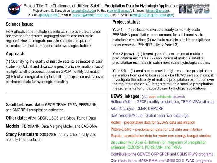
Project Title: The Challenges of Utilizing Satellite Precipitation Data for Hydrologic Applications Project team: S. Sorooshian (soroosh@uci.edu), K. Hsu (kuolinh@uci.edu), B. Imam, (bimam@uci.edu), X. Gao (gaox@uci.edu); P. Arkin (parkin@essic.umd.edu) and E. Amitai (eyal@radar.gsfc.nasa.gov) Project status: Year 1–(1) collect and evaluate hourly to monthly scale PERSIANN precipitation measurement for catchment scale hydrologic simulation; (2) evaluate multiple satellite precipitation measurements (PEHRPP activity: Year1-3). Year 2 (now) – (1) Investigate bias correction of multiple precipitation estimates; (2) application of multiple satellite precipitation estimates in catchment scale hydrologic studies. Year 3-5 – (1) continue to provide high-resolution precipitation estimation from grid to basin scales for NEWS investigations; (2) Investigate the reliability of multiple precipitation estimation over the mountain region; (3) integrate multiple satellite precipitation measurements for ungauged basin hydrologic applications. • Science issue: • How effective the multiple satellite can improve precipitation observation for remote ungauged basins and mountain regions? How to Integrate multiple satellite precipitation estimates for short-term basin scale hydrologic studies? • Approach: • (1) Quantifying the quality of multiple satellite estimates at basin scales. (2) Adjust and downscale precipitation estimation bias of multiple satellite products based on GPCP monthly estimates. (3) Effective merge of multiple satellite precipitation estimates at catchment scale for hydrologic modeling. • Satellite-based data: GPCP, TRMM TMPA, PERSIANN, and CMORPH precipitation estimates. • Other data: ARM, CEOP, USGS and Global Runoff Data • Models: PERSIANN, Data Merging Model, and SAC-SMA • Study Particulars: 2003-2007,hourly, 3-hour, daily, and monthly time resolution. NEWS linkages: (pull, push, collaborate, external) Hoffman/Adler – GPCP monthly precipitation, TRMM MPA estimates Arkin/Xie/Joyce: CMAP, CMPORH Dai/Trenberth/Maurer: Global basin river discharge Rodell – precipitation data for GLDAS data assimilation Peters-Lidard –precipitation data for LIS data assimilation Roads –precipitation data for water and energy budget studies Discussion with Adler & Hoffman for integration of precipitation estimates (CMORPH, PERSIANN, and TMPA) Contribute to the GEWEX GRP GPCP and CGMS IPWG programs Contribute to the NASA PMM and UNESCO G-WADI programs