Download
1 / 2
20 likes | 122 Vues
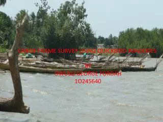
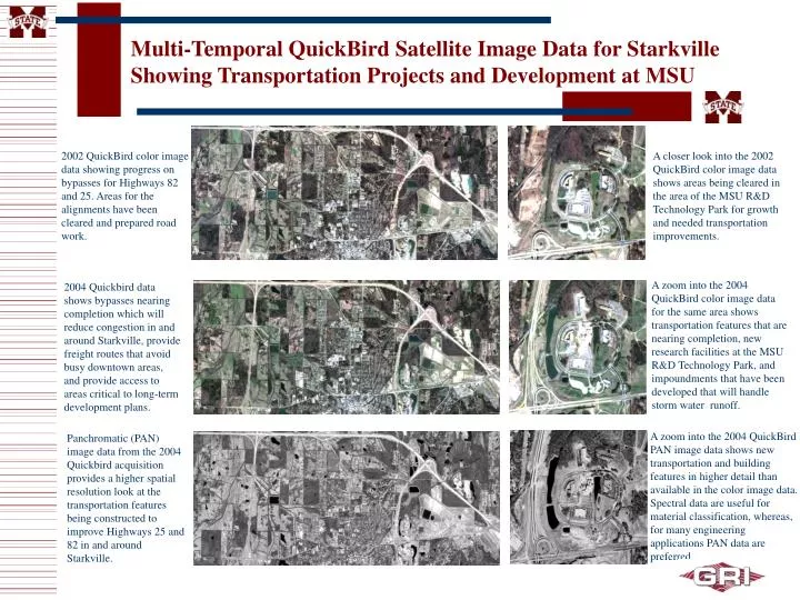
Multi-Temporal QuickBird Satellite Image Data for Starkville Showing Transportation Projects and Development at MSU. 2002 QuickBird color image data showing progress on bypasses for Highways 82 and 25. Areas for the alignments have been cleared and prepared road work.

E N D
Multi-Temporal QuickBird Satellite Image Data for Starkville Showing Transportation Projects and Development at MSU 2002 QuickBird color image data showing progress on bypasses for Highways 82 and 25. Areas for the alignments have been cleared and prepared road work. A closer look into the 2002 QuickBird color image data shows areas being cleared in the area of the MSU R&D Technology Park for growth and needed transportation improvements. A zoom into the 2004 QuickBird color image data for the same area shows transportation features that are nearing completion, new research facilities at the MSU R&D Technology Park, and impoundments that have been developed that will handle storm water runoff. 2004 Quickbird data shows bypasses nearing completion which will reduce congestion in and around Starkville, provide freight routes that avoid busy downtown areas, and provide access to areas critical to long-term development plans. A zoom into the 2004 QuickBird PAN image data shows new transportation and building features in higher detail than available in the color image data. Spectral data are useful for material classification, whereas, for many engineering applications PAN data are preferred. Panchromatic (PAN) image data from the 2004 Quickbird acquisition provides a higher spatial resolution look at the transportation features being constructed to improve Highways 25 and 82 in and around Starkville.
Multi-Temporal QuickBird Satellite Image Data Illustrating Transportation and Commercial Development Along Highway 25 Panchromatic (PAN) and multi-spectral image data of the areas in consideration for a connector between I-20 and Highway 25 to the east of the Jackson International Airport. QuickBird PAN image data (2003) with sub-meter resolution for I-20 and HWY 25 high-growth areas. A zoom into the 2003 and 2004 QuickBird color image data shown as CIR for areas experiencing high-growth rates along HWY 25. A zoom into the 2003 and 2004 QuickBird PAN image data showing areas of residential development in which new roads and houses are in construction and/or completed. Other areas are apparent that have been cleared and are being prepared for construction activities.