Download
1 / 85
870 likes | 889 Vues
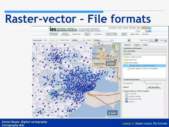
Raster-vector – File formats. GIS Spatial data models. M odel representation of reality in either material form (tangible) or symbolic form (abstract) simplifies the “real world” which is infinitely complex D ata model

E N D
GIS Spatial data models • Model • representation of reality in either material form (tangible) or symbolic form (abstract) • simplifies the “real world” which is infinitely complex • Data model • set of rules used to convert the infinitely complex real world into simple objects in a GIS • Differing GIS data models • GIS differ according to the way in which they represent real world • Data models fall into one of two categories • raster • vector
The raster data model • data representation • divides study area into rectangular grid of cells • data storage • uses a conventional sequence of row by row from the top left hand corner • the raster data model assigns a value (e.g. a colour) for every location or cell in the study area • layers of information • one set of cells and associated values constitutes a layer • simple data storage and data analyses
Raster spatial elements 1 1 Two different zones 1 1 2 a class • cell • smallest unit • zone • a set of contiguous cellsof the same value • analogous to a polygon • class • a classification (value or type) ofparticular phenomena
Components of the raster model • Resolution • the minimum linear dimension of the smallest geographic space for which data is recorded • Orientation • the angular difference between the direction north and the columns of the raster
Raster data compaction • Run-length encoding • 80.5MB down to 17.7MB • Block encoding • Chain coding
Raster data compaction • Quadtree
The vector data model • data representation • uses graphical primitives to represent discrete objects • primitives: • points • lines • polygons • data storage • not space filling • represented by a series of co-ordinate pairs • layers of information • composed of one or a number of vector data components • more complex data storage and analysis methodology
Vector data components • Points • fundamental object in the vector data model • Lines • are created by joining points • Polygons • sometimes called areas or regions • created from a closed set of lines • Identifiers • each object linked to appropriate attribute information via an identifier
Raster versus vector • Raster • positive • database structures were appealing due to their simplicity (especially with the remote sensing community) • spatial operations quick • uncertainty automatically reflected by cell size • negative • lineal features and outlines often crude • lineal operations more difficult • inaccuracies in parcel outlines • raster approach often sacrifices too much detail • large demand on memory for data storage
Raster versus vector • Vector • positive • lineal features displayed elegantly • accurate representation for precision graphics • detail easily represented • minimal data storage requirements • links to existing textual databases • negative • computing times for spatial analysis were excessive • early polygon overlay routines subject to errors, were expensive and slow • fine line detail could be misinterpreted for locational precision
Raster versus vector – the basic issues • spatial precision • costs of computing • mass storage requirements • characteristics of phenomena
Issues - spatial precision • Geographic or spatial precision • raster • unclear whether centre or edge of cell is precise location of co-ordinate • locational precision therefore 1/2 cell’s width and height • vector • can be encoded with any conceivable degree of precision (eg. single or double precision) • caution: “know” your source data! • real vector data accuracy may be worse than one line width
Issues - costs of computing • Hardware/software • raster • tend to be lower, running on inexpensive hardware configurations • spatial analysis processes tend to be quicker • vector • more complex geometrical algorithms required for spatial analysis • more expensive software required - development costs higher
Issues – mass storage • Mass storage - hard-disk requirements • raster • simple data structures - one memory location (one or two bytes) per cell • not efficient, although file compression techniques employed by some systems • memory requirements proportional to spatial variability of data • vector • little storage requirements for simple polygons • memory requirements proportional to complexity of objects • dependent upon precision of co-ordinates stored (single or double) • dependent upon how topological data structures are stored • generally less storage than raster
Issues – characteristics of phenomena • Spatial sampling of phenomena • raster • regularly spaced grid • disregards spatial variability • vector • irregular data sample sites can be managed • rapid variation at boundaries • notion of “fuzzy boundaries” • Features and objects • raster • cells are independent units not easily linked to complex objects • vector • complex objects can be handled as objects
Conclusions • Certain operations better handled in raster systems • Need for hybrid of both • need for algorithms to convert from raster to vector and vice versa
File formats - Overview • General file formats (beforethe web era) • Raster • TIFF, BMP, RAW • Vector • DXF, HPGL, DGN • Metafile • CGM, WMF, EPS, PDF • Graphics on the web • Standard raster formats (JPG, GIF, PNG) • Graphical plug-ins (SVG, MrSID, SWF, ...) • Database-driven solutions • GIS • Internet Map Servers • Special solutions on national mapping services
General file formats - raster • TIFF • BMP • RAW HOMEWORK!!!
General file formats - vector • DXF • HPGL • DGN HOMEWORK!!!
General file formats - metafile • CGM • WMF • EPS • PDF HOMEWORK!!!
Web formats - constraints File size (bandwidth) raster / vector pixel dimension amount of colors compression method Image size (screen) pixel dimensions Carefully choose colour space and file format for every type of graphic
Standard raster formats GIF JPG PNG GIF - 8 Kb. JPG - 71 Kb. PNG - 11 Kb.
GIF (Graphics Interchange Format) uses indexed color – max. 256 uses simple RLE (run–length encoding) compression best for full tints (graphs, maps, drawings) supports transparency supports animation (poor man’s video)
JPG(Joint Photographic Experts Group) uses full color uses flexible, customizable, but “lossy” compression best for graduated tones (photos), not ideal for homogenous areas
PNG (Portable Network Graphics) proposed by W3C uses indexed colour – max 256 supports transparency lossless compression compromise between GIF and JPG, slow spread
Image map Example: http://lazarus.elte.hu/hun/maps/magas-t/1tatra.htm Part of a diploma theses in 1998
Standard configuration map.gif <imgsrc=“map.gif”><br><i>Static</i> map Static map
Other raster (wavelet) formats MrSID (LizardTech) ECW (Erdas > Leica) Compression Engines (WIF) LuraTech LuraWave (LWF) Zoomify* (http://www.zoomify.com/)
Wavelet Wavelet compression is a form of data compression well suited for image compression. The goal is to store image data in as little space as possible in a file. Wavelet compression can be either lossless or lossy. Using a wavelet transform, the wavelet compression methods are adequate for representing transients, such as percussion sounds in audio, or high-frequency components in two-dimensional images, for example an image of stars on a night sky. This means that the transient elements of a data signal can be represented by a smaller amount of information than would be the case if some other transform, such as the more widespread discrete cosine transform, had been used. Wavelet compression is not good for all kinds of data: transient signal characteristics mean good wavelet compression, while smooth, periodic signals are better compressed by other methods.
MrSID Encoding MrSID technology uses lossless wavelet compression to create an initial image. Then the encoder divides the image into zoom levels, subbands, subblocks and bitplanes. After the initial encoding, the image creator can apply zero or more optimizations. While 2:1 compression ratios may be achieved losslessly, higher compression rates are lossy much like JPEG-compressed data. Decoding MrSID uses selective decoding meaning that the decoder does not have to decode the entire file to view a specific zoom level, image quality or scene for example.
ECW - Enhanced Compression Wavelet The format is optimized for aerial and satellite imagery. Map projection information can be embedded into the ECW file format to support geospatial applications. Supported by GIS software and image manipulation software (Mapinfo, ArcGIS, Erdas Imagine, Geomedia, Smallworld, Microstation, Global Mapper, Photoshop).
Other map formats Vector (hybrid/multimedia) SVF (Simple Vector Format) SWF (Flash, Adobe, formerly Macromedia) SVG (Adobe) WebCGM PDF (Adobe) VRML (Virtual Reality Modelling Language)
SVF – Simple Vector Format • SVF was the first vector format designed specifically for the Web, with the initial public specification published in 1994 and presented at the 2nd World Wide Web Conference. • Compact. • Streamable. An image can be displayed while the file is downloaded. • Notifications can be used to transparently give the user more information when moving around the image. • Practically no more development after 1996. At that time it was supported by ArchiCAD and MicroStation. The printing module was not freely available.
SWF (ShockWave Flash) FutureWave Software, a small company later acquired by Macromedia, originally defined the file format with one primary objective: to create small files for displaying entertaining animations. The idea was to have a format which could be reused by a player running on any system and which would work with slower network connections. Adobe acquired Macromedia in 2005. In 2008 Adobe dropped its licensing restrictions on the SWF format specifications. Originally the format was limited to presenting vector-based objects and images in a simple sequential manner, the format in its later versions allows audio (since Flash 3), video (since Flash 6) and many different possible forms of interaction with the end-user. Once created, SWF files can be played by the Adobe Flash Player, working either as a browser plugin or as a standalone player.
SVG (Scalable Vector Graphics) SVG is a family of specifications of an XML-based file format for describing two-dimensional vector graphics, both static and dynamic (i.e. interactive or animated). The SVG specification is an open standard that has been under development by the World Wide Web Consortium (W3C) since 1999 (based on Adobe's PostScript and Microsoft’s Vector Markup Language (VML). SVG images and their behaviours are defined in XML text files. This means that they can be searched, indexed, scripted and, if required, compressed. Since they are XML files, SVG images can be created and edited with any text editor, but specialized SVG-based drawing programs are also available (Inkscape). New browsers have a built-in SVG support (IE support is promising in the version 9).
WebCGM (Computer Graphics Metafile) • The original CGM file became standard in 1986. • Although CGM is not widely supported for web pages and has been supplanted by other formats in the graphic arts, it is still prevalent in engineering, aviation, and other technical applications (including GIS). • WebCGM supports the following "intelligent" functions: • Hyperlinking and document navigation • Picture structuring and layering • Search and query on WebCGM picture content.
PDF (Portable Document Format) • This format is the most important device-independent format to share rich content. • Originally the format was developed only for document exchange (1993). • In the latest versions forms, 3D and geo functions are also supported. • PDFs may be encrypted so that a password is needed to view or edit the contents. PDF files may also contain restrictions that provide further controls that limit copying, editing or printing. • A PDF file is often a combination of vector graphics, text, and raster graphics. The basic types of content in a PDF are: • text stored as such • vector graphics for illustrations and designs that consist of shapes and lines • raster graphics for photographs and other types of image