Download
1 / 13
130 likes | 250 Vues
Figure 1.1. Overview of the geography of Mexico (redrawn with permission from Rees, 1996). Figure 1.2. Digital terrain model of the Iztaccíhuatl and Popocatépetl volcanoes area. Figure 1.3. Three dimensional view of the relief in the Iztaccíhuatl and Popocatépetl volcanoes.

E N D
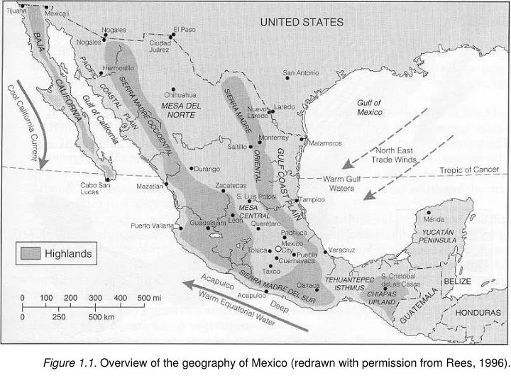
Figure 1.1. Overview of the geography of Mexico (redrawn with permission from Rees, 1996).
Figure 1.2. Digital terrain model of the Iztaccíhuatl and Popocatépetl volcanoes area.
Figure 1.3. Three dimensional view of the relief in the Iztaccíhuatl and Popocatépetl volcanoes.
Figure 1.4. Population in the Mexico City metropolitan area in the 20th century (from http://www.sru.ed).
Figure 1.5. Overview of the Iztaccíhuatl-Popocatépetl National Park and its surroundings and its location in Central Mexico.
Figure 1.6. Altitudinal profiles through the Iztac-Popo area from SW – NE, from E – W, and from N – S.
Figure 1.7. Typical volcanic soil on higher part (3500 m) of the Iztac-Popo area (photograph by R. Bobbink).
Figure 1.8. Geology of the Iztaccíhuatl and Popocatépetl volcanoes area.
Figure 1.9. Soils map of the Iztaccíhuatl and Popocatépetl volcanoes area.
Figure 1.12. Diagrams of monthly precipitation and mean temperature in Amecameca (2,470 m) and Hueyatlaco (3,557 m; Paso de Cortés).
Figure 1.13. Photographic view of the slopes of the Volcanoes (forests - grasslands - summit)(photograph by R. Bobbink).