Download

1 / 34
340 likes | 459 Vues
Bald Eagle Wildlife Study Using Geographical Information Systems. Project Proposal.

E N D
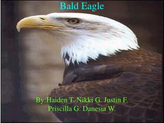
Bald Eagle Wildlife Study Using Geographical Information Systems
Project Proposal The State of Florida is looking for an area to set up increased protection for the bald eagle's habitat. I was tasked by the State of Florida to help identify an ideal location to set up this preserve. They would also like to know some of the manmade factors that could affect the survival of the species. The final decision will be made by the Conservation Board of Florida. After creating multiple maps showing the spatial relationship between bald eagle nests and factors that may affect the environment around those nests I have come up with two possible locations for a preserve. Of these two locations I recommend the selection of the area labeled Potential Area Two. http://www.nhptv.org/NATUREWORKS/baldeagle.htm
Bald Eagles • Bald eagles were named the National Symbol of the United States in 1782 • At the time their population was estimated between 25,000 to 75,000 in the lower 48 States (Huerta) • Bald eagles feed primarily on fish • Bald eagles are monogamous and lay 1 to 3 eggs a year • With the introduction of the pesticide DDT to the environment, the population of the bald eagle dramatically declined to 420 breeding pairs by 1963 • DDT banned • In 1973 they were listed as endangered by the Endangered Species Act • In the 30 years since the bald eagle’s numbers have grown to 4,450. • Florida has the second highest number of bald eagle breeding pairsin the lower 48 • Bald eagles remain threatened
Distribution of Bald Eagle Breeding Pairs in the United States Data taken from U.S. Fish and Wildlife Service and added to United States shapefile. <http://www.fws.gov/migratorybirds/issues/BaldEagle/baldeaglepopmapfinal.pdf>
Goals • Locate an area in Florida to focus the project on • use GIS to map out bald eagle nests • use different man made and natural variables near bald eagle nests to select potential locations for increased protection • Major roads, rivers and lakes, solid waste facilities and major cities
Bald Eagle Nest Shapefile Florida County Shapefile Downloaded from: Florida Geographic Data Library Downloaded from: US Census GIS Data Select by attribute only those nests that were active in 2006 Spatially join the Bald Eagle layer to the county layer Spatial Join Summarize the attribute table of the new shapefile using the FIPS column Use graduated colors choropleth map to show the distribution of bald eagle nests per county. Join attributes from the summarized table to the original county layer Symbology
Analysis of Choropleth Map • From the choropleth map I decided to select nine counties for a larger scale analysis of the bald eagle • Polk county had the greatest number of active eagle nests in 2006 • I selected Polk county and the following other counties for analysis: Volusia, Seminole, Orange, Lake, Alachua, Marion, Polk, Osceola
Bald Eagle Nest Shapefile Selected Area Shapefile Use ToolBox to merge the counties to create a single large polygon . Use the selected area shapefile to clip the bald eagle nest data by location Selected Area Merged Polygon Clip New Shapefile created of just those nests located inside the selected area.
Larger scale view of selected area with those eagle nests that fall within.
Perform the same clip operation to • Florida Major Roads • Florida Rivers and Lakes • Florida Solid Waste Facilities • Florida Major Cities
Bald Eagle Nest Clip Florida Major Roads Selected Area Use buffers to clip the bald eagle nest that intersect the roads buffer Create buffers around the Major Roads CLIP
Buffers around Roads scale 1:2,000,000 meters
Buffers around Roads Scale 1:400,000 meters
Roads & Bald Eagle Nest • Total Number of Bald Eagle Nests in Selected Area 578 • Put buffers around the roads to show how close the birds nests are. Use select by location to find out the number of nests inside the buffer. • 200 meter buffer: how many nests are within that buffer: 56 • 400 meter buffer: how many within this buffer: 118 • 800 meter buffer: how many within this buffer: 233 • 1600 meter buffer: how many in this buffer: 358
Bald Eagle Nest Clip Solid Waste Selected Area Use buffers to clip the bald eagle nest that intersect the solid waste buffer Create buffers around the Solid Waste Facilities CLIP
Buffers around Solid Waste Facilities Scale 1:2,000,000
Buffers around Solid Waste Facilities Scale 1:400,000 meters
Solid Waste Facilities & Bald Eagle Nest • Total Number of Bald Eagle Nests in Selected Area 578 • Put buffers around the solid waste facilities to show how close the birds nests are. Use select by location to find out the number of nests inside the buffer. • How many nests are within 200 meters: zero • How many nests are within 400 meters: 1 • How many nests are within 800 meters: 3 • How many nests are within 1600 meters: 10 • How many nests are within 3200 meters: 50 • How many nests are within 6400 meters: 145
Bald Eagle Nest Clip Rivers & Lakes Selected Area Use buffers to clip the bald eagle nest that intersect the rivers and lakes buffer Create buffers around the Rivers and Lakes CLIP
Buffers around Rivers & Lakes Scale 1:2,000,000
Buffers around Rivers & Lakes Scale 1:400,000 meters
Rivers & Lakes & Bald Eagle Nest • Total Number of Bald Eagle Nests in Selected Area 578 • Put buffers around the rivers and lakes to show how close the birds nests are. Use select by location to find out the number of nests inside the buffer. • How many nests are within 200 meters: 31 • How many nests are within 400 meters: 53 • How many nests are within 800 meters: 107 • How many nests are within 1600 meters: 182 • How many nests are within 3200 meters: 265 • How many nests are within 6400 meters: 346
Bald Eagle Nest Clip Major Florida Cities Selected Area Use buffers to clip the bald eagle nest that intersect the city buffer Create buffers around the Cities CLIP
Buffers around Florida Major Cities Scale 1:2,000,000
Buffers around Florida Major Cities Scale 1:400,000 meters
Major Cities & Bald Eagle Nest • Total Number of Bald Eagle Nests in Selected Area 578 • Put buffers around the cities to show how close the birds nests are. Use select by location to find out the number of nests inside the buffer. • How many nests are within 200 meters: zero • How many nests are within 400 meters: zero • How many nests are within 800 meters: zero • How many nests are within 1600 meters: 9 • How many nests are within 3200 meters: 31 • How many nests are within 6400 meters: 112
Final Map • For a final map I added buffers from each of the variables to the map • Chose the buffer based on what the average number of nest within the buffers was • The buffer closest to the average was chosen • Selected the bald eagle nests that did not intersect any of the buffers
Buffers around Cities, Roads, Rivers & Lakes, and Solid Waste Facilities Scale 1:2,000,000
Potential Sites for Extra Protection of Bald Eagles Potential Area 1 Scale 1:275,000 Potential Area 2 Scale 1:275,000
Conclusion The two possible areas for increase protection that I chose were chosen because they both had a large number of bird nests, were located near water supplies and were not intersecting any of the buffers that were created around the man made variables. Of the two areas I would suggest the second over the first because there is a larger area of land without major roads. It also appears from the raster data that there are more areas of water.
Future Research Suggestions • Study the selected areas at a larger scale • Study the selected areas with more variables • Add a habitat shapefile to find out what trees the bald eagles like to nest in • Study the possible future land use in the area • Add building shapefiles to a larger scale study • Add non major roads • Add information on bald eagle mortality events