Download
1 / 1
10 likes | 15 Vues
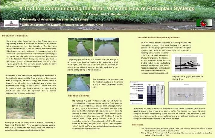
a). w. Sample Cross-Section. 1.3w. A Tool for Communicating the What, Why and How of Floodplain Systems. D. A. Farver 1 and D. Mecklenburg 2. 1 University of Arkansas, Fayetteville, Arkansas 2 Ohio Department of Natural Resources, Columbus, Ohio. Introduction to Floodplains.

E N D
a) w Sample Cross-Section 1.3w A Tool for Communicating the What, Why and How of Floodplain Systems D. A. Farver1 and D. Mecklenburg2 1 University of Arkansas, Fayetteville, Arkansas 2 Ohio Department of Natural Resources, Columbus, Ohio Introduction to Floodplains Individual Stream Floodplain Requirements Many stream miles throughout the United States have been impacted by humans in a way that has resulted in the streams being disconnected from their floodplains. This has been through channelization as well as impacts from urbanization. Urbanization can lead to an increase in impervious area in the watershed, an increase in runoff, an increase of water energy in the stream and ultimately stream incision and disconnection from the floodplain. “Active floodplains” are low-lying land on one or both sides of a channel where water commonly flows. Typical spring floods, often several in a year, inundate the active floodplain in an unimpacted stream system. As more people become interested in restoring streams, and reconnecting streams to their active floodplain, it is important to provide a tool to give people information on the ideal floodplain elevation and width for the stream they are interested in restoring. Using regional curves for dimension information, landowners, city/county engineers, developers, etc. can enter the cross-section of the existing system in a spreadsheet and see what elevation and what width a floodplain needs to be for the stream, and how much soil needs to be removed to reach the desired goal. The photographs above are of a channel that runs through a golf course under baseflow conditions (left) and during a flood event (right). The increased water level can be observed by looking at the bridge structure on the right hand side of the picture, and by looking at the first crossing. Awareness is now being raised regarding the importance of floodplains for stream stability. Once a stream is disconnected from its floodplain, too much energy from rainfall events is trapped in a small main channel and not allowed to spread onto the floodplain so energy can be dissipated. A stream with active floodplain is much more likely to adapt to a certain level of disturbance and return to equilibrium than a channel disconnected from its active floodplain. Regional curve graph developed for Central Ohio. The illustration to the left shows that the floodplain available to this channel is only 1.3 times the bankfull channel width Floodplain Guidelines The numbers 3, 5 and 10 make a useful “rule of thumb” for floodplain widths as it relates to stream stability. Three times the bankfull channel width makes a handy minimal floodplain target for “okay” signs of improvement. Floodplains less than three times the bankfull channel width (as shown above) have the tendency to exhibit signs of instability. “Good” stream system characteristics are often associated with floodplain 5 times the channel width. High quality streams, found in natural undisturbed areas, have floodplain widths of 10 to 30 channel widths. So 3 is okay, 5 is good and 10 is great. The exceptions to this “rule of thumb” are high gradient streams or streams that would not naturally form floodplains. Spreadsheet to enter cross-section information for the stream of interest (left) and the resulting graph of the stream cross-section (right). The maroon line shows the ideal floodplain elevation corresponding to the bench in the channel. The dotted line is the existing cross-section, and the cross-hatching shows where soil must be removed to get a floodplain of the desired width and at the desired elevation. Photograph of the Big Darby River in Central Ohio during a flood event. The Big Darby River has been designated a scenic river and has maintained high quality over time because of active floodplain access throughout the watershed. References Ohio Department of Natural Resources (ODNR). 2003. Draft factsheet. Floodplains: Critical to stream health. Division of Soil and Water. Columbus, Ohio. Whiting, P.J. and M. Pomeranets. 1997. A numerical study of bank storage and contribution to streamflow. Journal of Hydrology 202: 121-136.