Download
1 / 21
210 likes | 406 Vues
Evaluation of Multi-temporal and Multi-polarization ASAR for Boreal Forests in Hinton. David G. Goodenough Hao Chen Andrew Dyk Tian Han Pacific Forestry Centre Natural Resources Canada. © May 16, 2005. Project Objectives.

E N D
Evaluation of Multi-temporal and Multi-polarization ASAR for Boreal Forests in Hinton David G. Goodenough Hao Chen Andrew Dyk Tian Han Pacific Forestry Centre Natural Resources Canada © May 16, 2005
Project Objectives • Radarsat-2 has a significant improvements in capability compared with Radarsat-1:better spatial resolution and fully polarimetric. • Envisat ASAR alternating polarization (AP) mode can help to study the advanced capabilities of Radarsat-2 and make progress towards defining methods for potential use of multi-polarization C-band SAR data for forest applications. • Objectives: • Develop a forest land-cover classifier for multitemporal and multi-polarization ASAR APP data; focus on clear-cut, reforestation, coniferous, deciduous, and mixed wood in northern forested areas in Canada; determine effectiveness of C-band ASAR APP data for boreal forest mapping and change detection. • Perform data fusion analysis with multitemporal ASAR and Landsat ETM+ data and determine improvements of fused data over single sensor data sets.
Radarsat-2, ASAR, and Convair-580 • Radarsat-2, operating at 5.405 GHZ, will be able to image at spatial resolutions ranging from 3 to 100 meters with nominal swath widths ranging from 10 to 500 kilometers. In addition, Radarsat-2 will offer multi-polarization, a capability that aids in identifying a wide variety of surface features and targets. • Envisat ASAR is a C-band sensor with dual-polarization and ability to acquire data with broad swath coverage, range of incidence angles, polarization, and modes of operation. This study uses Envisat ASAR data for multitemporal SAR classification. • The Convair 580 C-band SAR can provide quad-polarization data (HH/HV/VH/VV), all in one scene, for polarimetric or for dual polarization combination analyses. Convair 580 data will help the study of Radarsat-2 data for forest applications and transformation of the technology to the end users of Radarsat-2 in the remote sensing service industry.
Study Site in Hinton, AB Landsat TM channel 5, 4, and 3 are shown as red, green, and blue channels. The white rectangles indicate the 29 township-ranges.
Image Acquisitions • Image acquisitions • Image information • ASAR Alternating Polarization Precision (APP): Channels: Two co-registered image channels corresponding to one of HV/HH, VV/VH, and HH/VV Spatial resolution: Approximately30 m Pixel spacing: 12.5 m Beam mode: IS 7 (42.5 – 45.5D) • Landsat ETM+: Channels: 6 Spectral channels Spatial resolution: Approximately30 m Cloud coverage: 0%
http://www.saforah.org • Image locations • ASAR APP metadata
ASAR Data Preprocessing • Single dual-pol. ASAR APP image: Radiometric calibration: Power Speckle filtering (Lee adaptive): 5x5 where the weighting function W is given by A. Lopes, R. Touzi and E. Nezry, "Adaptive speckle filters and Scene heterogeneity", IEEE Transaction on Geoscience and Remote Sensing, Vol. 28, No. 6, pp. 992-1000, Nov. 1990. Textures: Mean, Standard deviation, Entropy (11x11 window size) Orthorectification: 12.5 m pixel resampling • ASAR APP data fusion (HV/HH/VV/VH): Image fusion from a pair of two winter images: 35 days apart Image fusion from a pair of two summer images: 35 days apart ( Noise variation coefficient)
LOGIT non-Gaussian classification • To determine the effectiveness of the C-band Envisat ASAR data for forest typing, structure recognition, and disturbance detection, a hierarchical logistic classifier, LOGIT, was developed. • LOGIT is a hierarchical logistic non-parametric classification program: SAR: Poisson distribution. ETM+:Gaussian distribution Standard Gaussian Distribution Poisson Distribution Curves
ASAR Textures • Textures were used to extract additional information from original SAR image channels by looking at the statistics and value changes in small regions. • Different window sizes and grey levels were tested. The window size 11x11 and 32 grey levels were selected. The resulting texture images tend to have interesting patterns and formations that signified additional information for LOGIT classification. • Textures used in this study: Mean Standard Deviation Entropy Hall-Beyer, Mryka, “GLCM TEXTURE: A TUTORIAL” 2004, Department of Geography University of Calgary
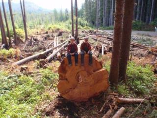
Training for LOGIT Classification • Training identified from Quickbird and aerial photos; • Examples of training samples from Quickbird: • 8 training classes were selected. Since the dominant forest in the study area was coniferous, two forest classes were defined. Coniferous contains at least 80% conifer and Mixed Wood contains all other forest types. Other classes were Clear-cut, Low regeneration (< 2 meters high), High regeneration (> 2 meters high), Scrub, Water, and Exposed land. Clear-cut Exposed Land Low Regeneration Dense Coniferous
LOGIT Classification on Fused ASAR APP (1) W – Winter data set S – Summer data set • Without Mixed Wood and High Regeneration: • The classification accuracies of the summer HV/HH/VV/VH image were lower than the winter HV/HH/VV/VH data. • Adding in Mixed Wood and High Regeneration: • Classification accuracies were greatly reduced. An example was given in the table (HV/HV/VV/VH).
Confusion Matrix of HV/HH/VV/VH(Winter ) • Adding Mixed Wood and High Regeneration to the classification of the winter HV/HH/VV/VH data set. • Classification accuracy: Average : 67.2% Overall: 44.5% • 26% of Coniferous was misclassified as Mixed wood, and 23.7% of Coniferous as High regeneration. • Low classification accuracies also occurred for the two regeneration classes: High Regeneration and Low Regeneration
LOGIT Classification on Fused ASAR APP (2) W – Winter data set S – Summer data set The Landsat-only classification had high average and overall accuracies. The Landsat +ASAR (W) data achieved 92.4% for the average, 3.5% higher than ETM+. The fused Landsat +ASAR (S) classification was at the same level as the Landsat +ASAR (W) image. The fused ASAR imagery, with both summer and winter images had the average accuracy of 72.6% and overall accuracy of 59.4%. If Landsat or other optical images are not available, this data combination should be the best alternative.
Confusion Matrix of HV/HH/VV/VH (Winter + Summer) • LOGIT classification on the Multi-Pol. (W)+(S) data set: Winter: HV, HH, VV, VH, + Means Summer: HV, HH, VV, VH, + Means • Classification accuracy: 72.6% Average 59.4% Overall • Coniferous classification was improved from 33.2% (a single winter multi-pol. data set) to 54.1%. But, classification accuracies on High Regeneration and Low Regeneration are still low.
LOGIT Classification Image ASAR-ETM+ Classification Image overlaid on 20020823 Landsat-7 ETM+ Image
Convair 580 quad polarization Data Future Study for Radarsat-2 • We have acquired Convair 580 images over Hinton in September 2004. • Conv580 data: Simultaneous C-Band in four polarization combinations, HH/HV/VV/VH • Conv580 data resolution: 6 – 10 meters. This will allow us to select the combination that is best for forest applications. • Compare LOGIT classification results between Convair 580 quad polarization data and fused ASAR APP data. • Perform Convair 580 polarimetric data decomposition: • Entropy/ decomposition (Ref. Cloude and Pottier, TGRS 1997) and three-component scattering decomposition (Ref. Freeman and Durden, TGRS 1998) • Wishart classification
Samples of Convair 580 Images over Hinton Township 48 Range 22 ~ 9.66 x 9.66 KM2 Township 50 Range 23 ~ 9.66 x 9.66 KM2
Conclusions • To prepare for Radarsat-2, Envisat ASAR APP and Landsat ETM+ were acquired over Hinton. Image preprocessing and data fusion from multitemporal ASAR images were performed. • A hierarchical logistic classification program, LOGIT, was implemented. LOGIT provided the non-parametric method of classification on remotely sensed data. • LOGIT was applied on ASAR APP, ETM+, and various fused image sets. The classification results revealed that • Landsat ETM+: High classification accuracy (Average 88.9%) • Fused ASAR and ETM+: Average 92.4%; that is 3.5% higher than ETM+ average classification accuracy • Multitemporal and multi-polarization ASAR data set (winter and summer): Average 72.6% • Single-date dual-polarization ASAR: Average 66% (HV winter) that is better than other single-date dual-polarization acquisitions. • More classification experiments on fused data sets, different band combinations, and multitemporal classification comparisons are under way.
Acknowledgements • We acknowledge the European Space Agency for providing Envisat ASAR data to Canadian Forest Service under the Category-1 Project 2481. • We thank Tarin Resource Services Ltd. of Calgary for providing online search of orthorectified aerial photos. • We appreciate the assistance of Steven Carey and Lionel Cai, co-op students at the Pacific Forestry Centre, Canadian Forest Service. • We are most grateful for financial support from Natural Resources Canada, the Canadian Space Agency, and the Natural Sciences and Engineering Research Council.