Download

1 / 27
270 likes | 422 Vues
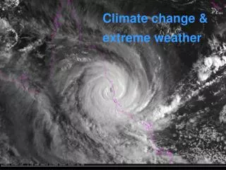
Climate change and fire-weather risk in south-eastern Australia. Kevin Hennessy . Observed changes in Australia. Most of the top 20 insured losses have been due to extreme weather events.

E N D
Climate change and fire-weather risk in south-eastern Australia Kevin Hennessy
Observed changes in Australia Most of the top 20 insured losses have been due to extreme weather events Black Saturday fires (7 Feb 2009): 173 dead,2029 properties destroyed (30% uninsured), 7000 people displaced, 61 businesses destroyed, over 8600 livestock dead (4000 sheep, 4200 beef cattle, 427 dairy cows) Insurance Council of Australia (2007)
Fire risk in Australia • Fire risk is influenced by a number of factors including weather, fuels, ignition, terrain, land management and suppression • The CSIRO-BoM study assesses potential changes to one of these factors, fire-weather risk, associated with climate change • The most important weather variables are temperature, humidity, wind-speed and rainfall
Fire danger index • McArthur Mark 5 Forest Fire Danger Index (FFDI; Noble et al,, 1980) is defined as: • FFDI = 2exp(0.987logD – 0.45 + 0.0338T + 0.0234V – 0.0345H) where: H = relative humidity from 0-100% T = air temperature oC V = average wind-speed 10 metres above the ground, in metres per second D = drought factor in the range 0-10
FFDI categories Categories of Fire Danger Rating (FDR). Taken from Vercoe [2003].
Daily peak FFDIs for large fires Date FFDI 13 Jan 1939 (SE Aus) 100 24 Jan 1961 (Dwellingup, WA) 110 7 Feb 1967 (Hobart, Tas) 78 16 Feb 1983 (Deans Marsh, Vic) 100 16 Feb 1983 (Trentham, Vic) 60 16 Feb 1983 (Adelaide to Warrnambool) > 100 8 Jan 1994 (Bankstown, NSW) 88 18 Jan 2003 (Canberra) 115 7 Feb 2009 (Vic) 100-192
Observed changes in FFDI Large daily, seasonal and annual variability
Fire intensity, fuel load and FFDI To get a fire of specified intensity, you need more fuel if the fire-weather index is lower Effect of Fuel Load on FFDI value for a fire with an intensity of 3500 kW m-1, the threshold for ‘uncontrollable’ fires. Adapted from data provided by Incoll [1994].
Report on climate change and fire-weather Bushfire Weather in Southeast Australia: Recent Trends and Projected Climate Change Impacts C. Lucas, K. Hennessy*, G. Mills and J. Bathols* Bushfire CRC and Australian Bureau of Meteorology * CSIRO Marine and Atmospheric Research September 2007 Consultancy Report prepared for The Climate Institute of Australia www.bushfirecrc.com/research/downloads/climate-institute-report-september-2007.pdf
Changes in fire weather risk in south-east Australia were assessed for the period 1973-2007 at 26 sites Site selection was limited by availability of daily temperature, rainfall, humidity and wind data
Observed changes in FFDI • The annual cumulative FFDI displays a rapid increase in the late-90s to early-00s at many locations. • Increases of 10-40% between 1980-2000 and 2001-2007 are evident at most sites. • The increases are associated with a jump in the number of very high and extreme fire danger days. AP Photo
Observed changes in FFDI The trend (red number at top left) is 51 FFDI units per year
Observed changes in FFDI Melbourne airport The trend (red number at top left) is 23 FFDI units per year
Observed changes in FFDI The trend (red number at top left) is 51 FFDI units per year
Observed changes in FFDI The trend (red number at top left) is 24 FFDI units per year
Climate change projections • Rather than simply extrapolating observed trends, we use computer models of the climate system driven by scenarios of greenhouse gas and aerosol emissions, and ozone depletion • The IPCC emission scenarios have various assumptions about demographic, economic and technological change Currently tracking the high scenario
Projected global warming For the IPCC emission scenarios, 23 climate models simulate a warming of 0.5 to 1.6°C by 2030, rising to 1.1 to 6.4°C by 2100 A1FI (estimated by CSIRO) IPCC 2007
Observed trends in temperature • Global average temperature is tracking the upper end of the IPCC projections • The rate of warming since 1975 is almost 0.2oC per decade Observed Rahmstorf et al 2007
Climate change scenarios for 26 sites were generated using 2 CSIRO climate models Model selection criteria: good simulation of 1961-1990 mean temperature, rainfall and MSLP; availability of daily data at “fine” resolution, e.g. 50 km Two climate change simulations were suitable: CCAM driven by the CSIRO Mark2 GCM, and CCAM driven by the CSIRO Mark3 GCM The mean warming is 0.5-1.5oC by 2020 and 1.5-3.0oC by 2050 CCAM Mark2: rainfall decreases except in autumn in northern Vic and southern NSW, humidity decreases in spring and summer and increases in autumn and winter, wind-speed decreases CCAM Mark3: rainfall decreases in spring-summer and increases in autumn-winter, humidity decreases, wind-speed increases
Simulated changes in mean and variability This study included simulated changes in the mean and variability of daily temperature, rainfall, humidity and wind-speed Changes in daily decile values for each calendar month were applied to observed daily data from 1974-2007 Observed daily temperature and rainfall data were considered high quality Observed daily humidity data were acceptable at most sites Observed wind data were not homogenised, so there were some jumps and missing data
% change in average no. of days with very high and extreme forest fire danger in 2020 and 2050 Extreme fire-weather days (high global warming) 2020 2050 Bendigo: +53-65% +135-230% Melbourne: +26-38% +81-136% Mildura: +25-38% +76-120% Sale: +15-45% +80-215% All changes are relative to a period centred on 1990
FFDI > 100 We defined a “catastrophic” fire-weather category for FFDI > 100. Only 12 of the 26 sites have recorded ‘catastrophic’ fire-weather days since 1973. The 2020 low scenarios indicate little or no change, except for a halving of the return period (doubling frequency) at Bourke. The 2020 high scenarios show ‘catastrophic’ days occurring at 20 sites, 10 of which have return periods of around 16 years or less. By 2050, the low scenarios are similar to those for the 2020 high scenarios. The 2050 high scenarios show ‘catastrophic’ days occurring at 22 sites, 19 of which have return periods of around 8 years or less, while 7 sites have return periods of 3 years or less.
Longer fire seasons Median FFDI for summer, autumn, winter and spring for “now” (1973-2007), 2020 and 2050 at Melbourne and Canberra The median FFDI increases in all seasons (mostly spring and summer), implying longer fire seasons
Adaptation challenges • Longer and more intense fire seasons present significant challenges for adaptation • Greater social, environmental and economic costs • More control-burning, smoke pollution and respiratory illness • More volunteer fire-fighters, more pressure on families/employers • Better weather forecasts and early warning systems • New technology for fighting fires • More disaster relief payments & counselling services • Better protection of water catchments & plantation forests • Better emergency plans (stay or go) • Planning guidelines for the urban/rural fringe • Insurance premium incentives for those that reduce their fire risk • Building codes/designs with reduced flammability
Uncertainties • Quality of observed daily wind and humidity data at most sites in Australia • The effect of scenarios based on other climate models • Assessment of daily-annual variability in FFDI, not just annual averages • Changes in ignition (natural and human-induced) • Changes in fuel load, allowing for carbon dioxide fertilization on vegetation • Potential impacts on biodiversity, water yield and quality from fire affected catchments, forestry, greenhouse gas emissions, emergency management and insurance AP Photo & The Age
Research priorities • Testing and rehabilitation of observed humidity and wind data (supported by Bushfire CRC and BoM) • Creation of regional climate change scenarios from other models (underway) • Assess fire-weather risk over the whole of Australia (underway) • Fine scale fire modelling that captures vegetation and terrain features and fire management, e.g. using FIRESCAPE (Sydney basin project) • Hydrological and ecological modelling to assess impacts on water and biodiversity