Download
1 / 15
150 likes | 303 Vues
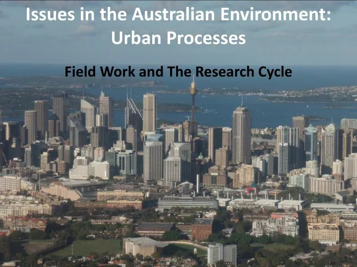
Issues in the Australian Environment: Urban Processes. Field Work and The Research Cycle . Field Study Area. Millers Point. Walsh Bay. Barangaroo. Circular Quay. Darling Harbour. How are these areas changing?. The Research Cycle . 1. Identify the aim/purpose of the investigation.

E N D
Issues in the Australian Environment: Urban Processes Field Work and The Research Cycle
Field Study Area Millers Point Walsh Bay Barangaroo Circular Quay Darling Harbour How are these areas changing?
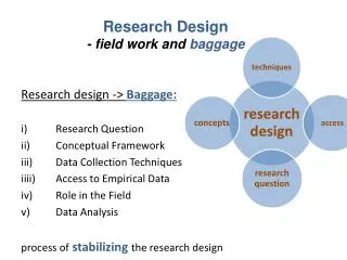
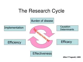
The Research Cycle 1. Identify the aim/purpose of the investigation 9. Where appropriate, take action 2. Generate focus questions to Guide the investigation 8. Propose individual or group action in response to the findings 3. Which primary and secondary data are needed to answer the focus questions 7. Select methods to effectively communicate the research findings 4. Identify the techniques that will be used to collect the data 6. Process and analyse the data collected 5. collect primary and secondary data
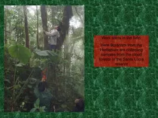
Identifying the Aim or Purpose Our aim or purpose is to investigate the impact of urban growth and decline on the biophysical and built environments in the field study area. We already have some secondary data on the field study area On our field study we will gather primary data at four locations by: • observing the biophysical & built environments • testing the biophysical & built environment • interviewing stakeholders Location 1 - Darling Harbour - Pyrmont Bridge to King Location 2 – Millers Point Location 3 – Walsh Bay Location 4 – Circular Quay West Street Wharf
Focus questions to guide the investigation How is the Harbour foreshore being used? How has the land use changed and what is the impact on the biophysical and built environment? What issues have arisen from Urban Growth & Decline? How are the issues being addressed?
Primary and secondary data are needed to answer the focus question How is the Harbour foreshore being used? Primary data Secondary data • Direct observation • Field Sketches • Photographs • Video • Sound levels • Temperature • Water testing • Wind speed • Interviews • Class notes • Internet sites • Class Blog • ABS data • Video clips • Newspaper articles • Maps • Photographs • Books
Primary and secondary data are needed to answer the focus question How has the land use changed and what is the impact on the biophysical and built environment?
Identify the techniques that will be used to collect the data How has the land use changed and what is the impact on the biophysical and built environment? Water testing • Phosphates • Nitrates • Ph • Turbidity
Phosphates Phosphorous is a nutrient but high levels cause a loss of dissolved oxygen 1 ppm excellent; 2 ppm good; 4 ppm fair Phosphate pollution can enter the water ways because of human sewage, agricultural, pesticide and fertilizer runoff, urban storm water runoff, and industrial waste.wastedischarge
pH pH is a measurement of the acidic or basic quality of the waters Natural water has a pH between 6.5 & 8.2 • Most aquatic organisms adapt to specific pH levels and may die if there is a shift in these levels and this can be affected by industrial wastes
Turbidity Turbidity is a measured in NTU or Nephelometric Turbidity Units 5 NTU 50 NTU 500 NTU Turbidity of drinking water should be below 5 NTU, ideally below 1 NTU Turbidity is a measure of the degree to which the water looses its clarity or transparency because of suspended solids.
Primary and secondary data are needed to answer the focus question What issues have arisen from Urban Growth & Decline? Contamination of harbour sea bed? Traffic congestion ? Road closures? Closing down of businesses? High density housing? Noise pollution? Wind tunnelling? oil and rubbish in the water? Overshadowing? Privacy issues for residents? Unsympathetic infill? Reduced air quality in the area? Pollution? Increased road or water traffic ? Dilapidated Houses? Vandalism ? Dust and construction noise?
Primary and secondary data are needed to answer the focus question How are the issues being addressed? Planning NSW NSW Road Transit Authority (RTA) • NSW Housing NSW Maritime Aust Dept of Customs & Excise Government Aust Dept of Immigration & Citizenship NSW Dept of Environment Climate Change & Water Sydney City Council NSW Transport & Infrastructure
Primary and secondary data are needed to answer the focus question How are the issues being addressed? Australian Institute of Architects Barangaroo Action Group Lend Lease Millers Point Residents’ Action Group Cruise & Charter Boat Operators Community & Commercial Millers Point Festival Darling Harbour Tenants Mirvac Transfield Tenants & Businesses of Dawes Point, The Rocks & Circular Quay Walsh Bay residents Tourists
More sustainable buildings with Building Green Star Ratings How are the issues being addressed? • The nine Green Star rating tools are: • Management • Indoor Environment Quality • Energy • Transport • Water • Materials • Land Use & Ecology • Emissions • Innovation All buildings in the Barangaroo project must achieve 5 Green Star rating or above