Download
1 / 4
40 likes | 182 Vues
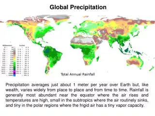
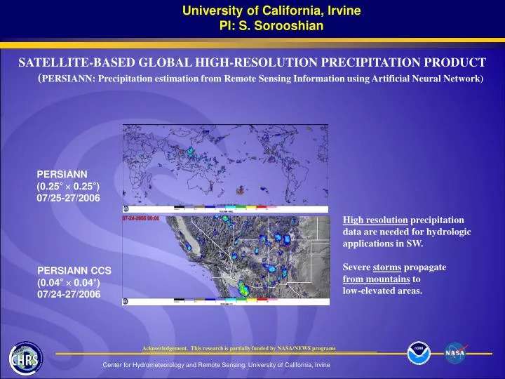
University of California, Irvine PI: S. Sorooshian. PERSIANN (0.25 ° 0.25°) 07/25-27/2006. High resolution precipitation data are needed for hydrologic applications in SW. Severe storms propagate from mountains to low-elevated areas. PERSIANN CCS (0.04 ° 0.04°)

E N D
University of California, Irvine PI: S. Sorooshian PERSIANN (0.25° 0.25°) 07/25-27/2006 High resolution precipitation data are needed for hydrologic applications in SW. Severe storms propagate from mountains to low-elevated areas. PERSIANN CCS (0.04° 0.04°) 07/24-27/2006 Acknowledgement. This research is partially funded by NASA/NEWS programs SATELLITE-BASED GLOBAL HIGH-RESOLUTION PRECIPITATION PRODUCT (PERSIANN: Precipitation estimation from Remote Sensing Information using Artificial Neural Network)
University of California, Irvine PI: S. Sorooshian Acknowledgement. This research is partially funded by NASA/NEWS programs Local Standardized Precipitation Index (SPI) for Hydro-climate Applications SPI is an index used by National Drought Mitigation Center (NDMC) for climate monitoring, in particular, operational drought detection and triggers of the policy responses (Hayes et al. 1999). Currently, NDMC produces gauge-based monthly SPI for each U.S. climate division. The demo shows the PERSIANN data are expanded to produce local SPI based on the climate divisions long-term precipitation data. SPI calculation requires long-term (> 30 yrs) precipitation data to derive Precipitation Probability Density Function (PDF) for an area. Based on the PDF,the dry-wet climate index-SPI is calculated from the past month’s precipitation.
University of California, Irvine PI: S. Sorooshian SPI Data for Local Water Resource Managements (2005 six-month SPI)
University of California, Irvine PI: S. Sorooshian