Download
1 / 18
180 likes | 322 Vues
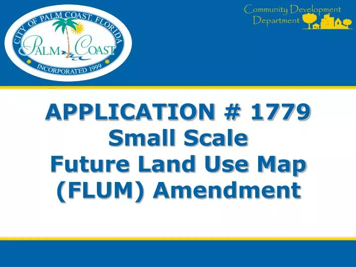
APPLICATION # 1779 Small Scale Future Land Use Map (FLUM) Amendment. Small-Scale Amendment. General Characteristics 10 acres or less, and residential density below 10 units/acre or equal in density No State agency review required Adopt at any time Effective 31 days after adoption.

E N D
APPLICATION # 1779 Small Scale Future Land Use Map (FLUM) Amendment
Small-Scale Amendment • General Characteristics • 10 acres or less, and residential density below 10 units/acre or equal in density • No State agency review required • Adopt at any time • Effective 31 days after adoption
COMPREHENSIVE PLAN REVIEW • Comprehensive Plan Amendments – Legislative • Standard of Review – “Fairly Debatable” • Review Criteria: • Public Facilities Impact – Analysis is based on Maximum Theoretical Yield • Impact does not degrade public facility below adopted Level of Service (LOS) • Internal Consistency with Comprehensive Plan Goals, Objectives and Policies.
Background and Location Map • Site Area - 2.75 +/- Acres • Current Use – Vacant • Current Zoning – SFR-3 • Current FLUM – Residential • Proposed FLUM – .29 (.37) acres Mixed-Use and 2.46 (2.38) acres Greenbelt
EXISTING FUTURE LAND USE MAP • North- Mixed Use • West- Mixed use • South - Residential • East- Residential
EXISTING ZONING • North- Parks and Greenways, COM-2 • West- OFC-2 • South- Single Family Residential • East-Single Family Residential
EXISTING USES • North- Vacant, Retail • West- Office Use • South- Vacant • East- Single-family Residential
MAXIMUM DEVELOPMENT ANALYSIS • No significant impact on Maximum Development Potential • Increase of 2,526 (3224) sq. ft. of non-residential use • Decrease of 27 dwelling units
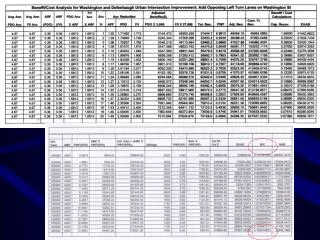
MAXIMUM DEVELOPMENT ANALYSIS – Non-Residential TABLE 1 – FLUM DESIGNATION MAXIMUM INTENSITY ALLOWED # of Acres Maximum FAR Maximum sq. ft. (1) Proposed FLUM: Mixed Use (Commercial) 0.29 0.50 6316 Greenbelt (Public/Semi-Public Use) 2.46 0.30 32147 Maximum Intensity Permitted Under Proposed FLUM 2.75 38463 Residential (Public/Semi- Current FLUM: Public 2.75 0.30 35937 NET CHANGE 2526 (3224) Footnotes: (1) Max Sq. Ft. = # of Acres X Max. FAR X 43560 sq. ft./acre
PUBLIC FACILITIES IMPACT ANALYSIS • No significant impact on public facilities • Slight increase in demand for non-residential uses • Decrease in demand for residential uses
CONSISTENCY WITH COMPREHENSIVE PLAN • Consistent with policies regarding location of mixed use areas. • Consistent with economic development objectives • Proposal to designate 2.46 (2.37) acres to Greenbelt provides additional protection for adjacent residential area.
FINDINGS • The proposed FLUM amendment is consistent with the Goals, Objectives, and Policies of the adopted Comprehensive Plan.
RECOMMENDATION CURRENT Staff recommends approval of Application #1779. A Future Land Use Map (FLUM) amendment for a 2.75+/- acre parcel from Residential to .29 acres of Mixed Use and 2.46 acres of Greenbelt. AMENDED Staff recommends approval of Application #1779. A Future Land Use Map (FLUM) amendment for a 2.75+/- acre parcel from Residential to .37 acres of Mixed Use and 2.38 acres of Greenbelt
REVISED PROPERTY BOUNDARY Residential Area Current Proposed Existing Boundary Line Total Site Area – 2.75 acres Residential to Greenbelt- 2.46 ac. Residential to Mixed Use - .29 ac. Limited perimeter landscape area/no wall Amended Proposed Original Proposed Boundary Line Total Site Area – 2.75 acres Residential to Greenbelt- 2.38 ac. Residential to Mixed Use - .37 ac. Expanded landscape area/ with wall