Download
1 / 30
300 likes | 385 Vues
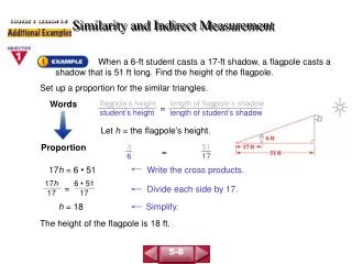
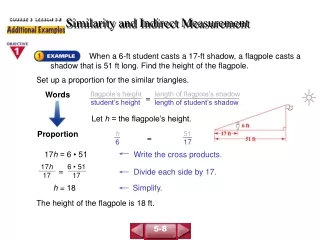
Semantic Similarity Measurement and Geographic Applications Introduction. Dr. Martin Raubal Department of Geography, UCSB raubal@geog.ucsb.edu. Overview. Instructor Organization Goals Schedule Introduction to the topic. Instructor.

E N D
Semantic Similarity Measurement and Geographic ApplicationsIntroduction Dr. Martin Raubal Department of Geography, UCSB raubal@geog.ucsb.edu geog 288MR, spring 08
Overview • Instructor • Organization • Goals • Schedule • Introduction to the topic geog 288MR, spring 08
Instructor • Instructor: Dr. Martin Raubal, raubal@geog.ucsb.eduhttp://www.geog.ucsb.edu/~raubal/ • Office (hours): Wednesday 2-4pm, EH 5713 • Phone: 893-4839 geog 288MR, spring 08
Class meets • Thursday 1-3pm, EH 5824 geog 288MR, spring 08
Textbook & literature • No textbook • Literature online: http://www.geog.ucsb.edu/~raubal/Courses/288MR_Spring08_Papers/ geog 288MR, spring 08
Organization • Course Website: http://www.geog.ucsb.edu/~raubal/Courses/288MR_SemSim_Spring08_schedule.pdf • Weekly readings • Class participation is mandatory! geog 288MR, spring 08
Assignments • Weekly brief critical commentaries (not longer than 1 page each) plus 3 questions connected to the readings (possibly related to your own field of study) to be discussed in class. • Please hand in a printed version at the beginning of each session. Late assignments will not be accepted and count as failed. • Lead one session including presentation of the weekly material (and possibly additional material) and discussion. geog 288MR, spring 08
Grading • Your presentation & discussion lead (35%) • Written assignments (35%) • General class participation (30%) Registration 2-4 hours!? geog 288MR, spring 08
Goals • Identify and recognize the importance of semantic similarity measurement for GI Science & Systems (data retrieval, integration, etc.). • Explore theoretical models and practical applications. • Get to know relevant literature. • Discuss, write, and present. geog 288MR, spring 08
Schedule http://www.geog.ucsb.edu/~raubal/Courses/288MR_SemSim_Spring08_schedule.pdf Take the lead for one session. geog 288MR, spring 08
You • Who are you and what is your background? • What is your motivation to participate in this class? • Semantic similarity measurement? Any experience? • How does it relate to your own research? geog 288MR, spring 08
Applications!? • Think of applications where semantic similarity is of relevance for GI Sciences. geog 288MR, spring 08
Motivating example (1) • Customer of OS wants to set up flood warning system. • Need for existing flooding areas to analyze current flood defense situation in U.K. geog 288MR, spring 08
Motivating example (1) • OS Master Map: • geographic & topographic • information on areas used for flooding but not designated as such • ‘Watermeadow', 'carse‘, 'haugh' identified as flooding areas by their semantic description only (properties in ontology). geog 288MR, spring 08
Motivating example (2) User conceptualization of roads & residential areas System model of roads & residential areas Roads overlap residential areas? Intersect to find roads going through residential areas geog 288MR, spring 08
Semantic interoperability • “Capacity of (geographic) information systems and services to work together without the need for human intervention” (Harvey, Kuhn et al. 1999) • Achieving sufficient degree of semantic interoperability => necessary to determine semantic similarity between concepts. geog 288MR, spring 08
Similarity (psychology) “Similarity is fundamental for learning, knowledge and thought, for only our sense of similarity allows us to order things into kinds so that these can function as stimulus meanings. Reasonable expectation depends on the similarity of circumstances and on our tendency to expect that similar causes will have similar effects" [Quine 1969, p. 114]. geog 288MR, spring 08
Computer science • Similarity plays major role to enable machine-based solutions: decision support systems, data mining, pattern recognition. • Semantic information retrieval: similarity indicates relevance of results with regard to being similar to the query. geog 288MR, spring 08
Concept A concept is "a mental representation of a class or individual and deals with what is being represented and how that information is typically used during the categorization" [Smith 1989, p. 502]. Concept vs. Category? geog 288MR, spring 08
Concepts in knowledge representation • Conceptual knowledge can be represented in ontologies that consist of specifications of concepts, relations and axioms. • Relations link concepts together and enable reasoning and measurement within an ontology. • Taxonomical (hierarchical) relations are the most important for reasoning and structuring knowledge. geog 288MR, spring 08
dist (Bus, Ferry) < dist (Bus, Bike) geog 288MR, spring 08
Similarity measurements • Approaches from different research areas (psychology, computer science, artificial intelligence) => apply to ontology-based semantic similarity measurement. • Application areas: • Information retrieval & integration • Data mining & maintenance • Categorization • Natural-language processing • Pattern recognition geog 288MR, spring 08
Measure and representation Representational model used to describe concepts determines semantic similarity measure (based on one notion of similarity). Representation => similarity measure geog 288MR, spring 08
Semantic similarity measurement • How close are two entities to each other conceptually? • Value between 0 and 1: • ‘0’ => no similarity • ‘1’ => both entities are equal • Different measurement theories. geog 288MR, spring 08
relations not explicitly represented Schwering (2008) geog 288MR, spring 08
Topics tackled in this seminar • Psychological models to explain human similarity judgment • Approaches to similarity in different areas / disciplines • What is representation? • Representation of geographic semantics • Semantic interoperability geog 288MR, spring 08
Topics tackled in this seminar • Theories for measuring semantic similarity • Feature-based models • Geometric models • Similarity measurement in context • Semantic similarity vs. semantic relatedness • Measurements using a semantic similarity serverhttp://128.176.133.142:8080/SimInterface/ geog 288MR, spring 08
Topics tackled in this seminar • Use of similarity measurement in geographic applications: • Geographic information retrieval • Hydrography • Land use / land cover classification • Wayfinding and landmarks • World knowledge in Wikipedia • … geog 288MR, spring 08
Reading for next session • R. Goldstone and J. Son (2005) Similarity. in: K. Holyoak and R. Morrison (Eds.), Cambridge Handbook of Thinking and Reasoning. Cambridge University Press, Cambridge. • Schwering, A., Approaches to Semantic Similarity Measurement for Geo-Spatial Data: A Survey. Transactions in GIS, 2008. 12(1): p. 5-29. • A. Rissland (2006) AI and Similarity. IEEE Intelligent Systems (May-June 06): 39-49. geog 288MR, spring 08