Download
1 / 19
220 likes | 543 Vues
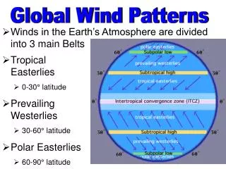
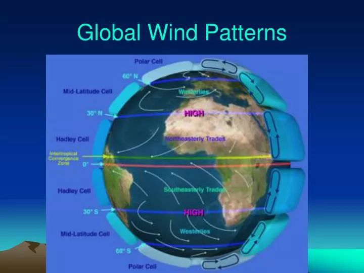
Global Wind Patterns. The circulations of the atmosphere (winds) and oceans (currents) are driven by sunlight hitting the earth’s surface more directly near the equator a LOT of this sunlight energy hits the tropics, between 23.5 0 North and South of the equator. Caused by uneven heating.

E N D
The circulations of the atmosphere (winds) and oceans (currents) are driven by sunlight hitting the earth’s surface more directly near the equatora LOT of this sunlight energy hits the tropics, between 23.50 North and South of the equator. Caused by uneven heating
What Makes the Wind Blow? Three real forces (gravity, pressure gradient, and friction) push the air around Two apparent forces due to rotation (Coriolis and centrifugal) Large-scale flow is dominated by gravity/pressure and Coriolis … friction and centrifugal important locally
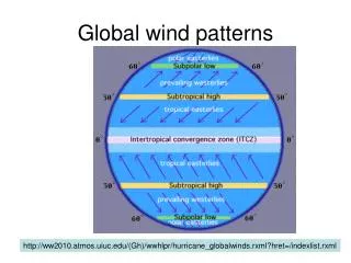
InterTropical Convergence ZoneITCZ the “doldrums”
If Earth did not rotate, wind patterns would be simply N to South along the surface • Thermal convection leads to formation of convection cell in each hemisphere • Heat Energy is transported from the tropics toward poles in upper atmosphere • Cold air sinks and shuttles back toward equator along surface
Coriolis effect But the earth rotates, so there is a tendency for objects moving over long distance (like air masses) to curve due to “coriolis effect” • Curve to right in N. Hemisphere • Curve to left in S. Hemisphere • This leads to winds generally blowing in east/west directions and having spin to them
CORIOLIS EFFECT • THE ROTATION OF THE EARTH CAUSES THE AIR TO MOVE AT ANGLES FROM THE EQUATOR TO THE POLES AND BACK. • http://uwf.edu/atc/projects/coriolis/main.swf • http://www.classzone.com/books/earth_science/terc/content/visualizations/es1904/es1904page01.cfm?chapter_no=visualization
See coriolis effect as high pressure wind blows into a low pressure air mass • Wind blowing in curve to the right in N. hemisphere • Thus, low pressure system has air spinning counterclockwise • This pattern creates tornadoes and hurricanes as well
Heat Exchange in air masses Warm, humid air rises, dry clear air sinksCreates 3 huge convection/circulation cells in each hemisphere
Prevailing winds are created by coriolis effect curving their paths Add these prevailing winds to your globe from north to south: Polar Northeasterlies Westerlies Northeasterly Tradewinds Doldrums Southeasterly Tradewinds Westerlies Polar Southeasterlies
Wind • Wind blows from high pressure air masses to low pressure • Winds named westerly wind IF blowing from the West • Wind spead increases as pressure gradient increases (steeper isobars)
Low pressure areas • Warm, humid air rises, expands and condenses = causing a low pres air mass at surface and condensation above (lots of rain or snow) • Global lows at Equator and polar region at 600 N and S.
High Pressure Areas • Dense, dry air (can by cold dense or hot arid) sinks due to gravity = creating high pressure at surface and outward blowing wind, very little precipitation • 30 latitude is areas of most large deserts like Sahara in Africa, Saudi Arabian deserts, Asians Desert or Death Valley USA • Global high pressure regions at 30° N and S as well as poles at 90° N and S
dry wet dry wet dry wet dry
Ferrel cell Hadley Cells
Key features of three cell model • Hadley cell takes heated air away from the tropics - TROPICS: low pressure air rises near equator - MUCH RAIN -DESERT ZONE: condensed, high pressure air descends near 30 degrees - clear skies! • Ferrel Cell - driven by heat transports of eddies - Polar air rises near 60 degrees and descends near 30 degrees - explains surface westerlies from 30-60 • Weak (WUSSIE-BABIES) winds found near • Equator (doldrums) • 30 degrees (horse latitudes) • Boundary between cold polar air and mid-latitude warmer air is the polar front
Understanding the General Circulation 1. Unequal solar heating between the equator and poles. Atmospheric general circulation moves heat toward the north and south poles.. 2. In a Hadley cell, warmer air rises and moves poleward. Equator-to-pole Hadley cell is impossible. The Earth rotates! 3. In the Northern Hemisphere, air is pushed to the right as it moves; in the Southern Hemisphere, air is deflected toward the left. The Coriolis effect. - rotation produces trade winds; surface westerlies in NH; upper tropospheric jet streams. 4. Ferrel cell runs backwards! Transports heat the wrong way, towards the equator! 5. The Ferrel cell is weak, so does not move as much energy as the other cells.
Global Wind and Pressure Patterns Deserts: belts of persistent high atmospheric pressure centered at about lat. 30º N and S Polar Front: front lying between cold polar air masses and warm tropical air masses Intertropical Convergence Zone (ITCZ): Where convergence of air masses along the equatorial trough Hadley Cell: low-latitude atmospheric circulation cell with rising air over the equatorial trough and sinking air over the subtropical high-pressure belts
Thermal Wind Balance Produces Jet Streams • Hot tropics and cold poles produce westerly high altitude jet streams at middle latitudes like ours.