Download

1 / 18
180 likes | 291 Vues
Warm up. QUIETLY compare the maps at your table What do they have in common?. Warm up. Which is largest- Greenland, South America or Africa?. Warm up. What makes a good science project? good explanation, testable hypothesis, answer Good topic Model/ good visual display

E N D
Warm up • QUIETLY compare the maps at your table • What do they have in common?
Warm up • Which is largest- • Greenland, South America or Africa?
Warm up • What makes a good science project? • good explanation, testable hypothesis, answer • Good topic • Model/ good visual display • Evidence, science log, Conclusion • Correct info/examples • Good experimental design controls/variable
What is a map? • A model representing a place • Globe is the most accurate model/map • Other maps are easier to carry and may have the details you want
What makes a good/useful map? • Scale • Clarity • Legend • Index • Inset map • Accurate information • Color • Fits your purpose • Compass rose
Warm up • (Table) • What do the latitude and longitude of Boston, Anaheim and St. Petersburg tell us? • Region of country, neighbors, plate • Hemisphere • Coast - longitude • Climate – latitude • Time zone
Boston – 42o N, 71oW • Anaheim – 33oN, 117oW • St. P – 27oN, 82oW Latitude, longitude Tells distance from equator, distance from Prime Meridian
Warm up • Draw a scale model of your table
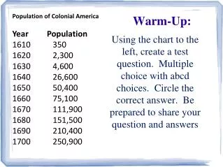
Scale • Measure then shrink or grow • Map scale the ratio between the model and actual • 1:25000 • 1cm to 25 000 cm – Boston topographic map’s scale or 1 cm to 250 m (0.25km)
Mercator – cylindrical, distorts near poles, good for navigation, line of latitude and longitude are perpendicular • Planar – gnomic, polar projection, good at a pole, distorts equator, etc • Conic – polyconic, good for smaller areas, US map
Warm up What’s the elevation of BLS?
Globes are somewhat cumbersome • 2 dimensions representation • What is the best type of map projection? • Why?
Warm up • Why is it important to be able to measure the Earth in Latitude and Longitude?
Warm up • What are the most important points or line to know on a globe or map?
Warm up • In what situation might it be useful to know your latitude and longitude?
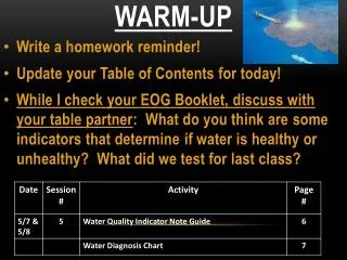
test • Multiple choice – 15, at most • Latitude/longitude – find the locations • Topographic map – draw a profile and interpret
suggestions • Review your notes/activities/hw • Review text • Complete the review sheet • Look through the power point on Teacher web • Quiz self/friends • Explain maps to mom, dad, the pet and your siblings