Download
1 / 15
150 likes | 271 Vues
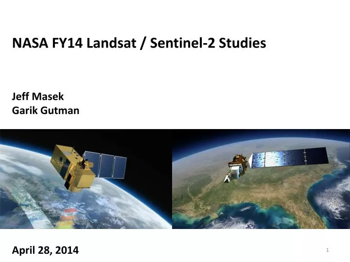
NASA FY14 Landsat / Sentinel-2 Studies Jeff Masek Garik Gutman April 28, 2014. Background. Sentinel-2 is the “Landsat-like” component of the EU Copernicus environmental monitoring program MSI VSWIR coverage from 0.43-2.3 micron (10-60m resolution)

E N D
NASA FY14 Landsat / Sentinel-2 Studies Jeff Masek GarikGutman April 28, 2014
Background • Sentinel-2 is the “Landsat-like” component of the EU Copernicus environmental monitoring program • MSI VSWIR coverage from 0.43-2.3 micron (10-60m resolution) • Sun-synch orbit @ 786km altitude w/ 10:30am crossing • 290km swath width (+/- 10.1 degrees at telescope) • 10-day repeat at equator for each satellite (5 days w/ Sentinel-2a,b; 2-3 days with S2ab + L8) • Sentinel-2a expected to launch April 2015 • Initial focus on Europe & Africa, global acquisitions start ~1 year later • Sentinel-2b to launch 2016 • Sentinel “free and open” data policy now ratified by EU • USGS and ESA working to secure “mirror” S2 archive at EROS
What’s Needed to Make Full Use of Sentinel-2 Data? • Cross-calibration with Landsat / MSI Characterization • Access to S2 L1C Data (USGS) • TOA, orthorectified reflectance • 100 x 100km UTM tiles • “Fundamental” Data Records • S2 directional surface reflectance • L8 (+ Landsat archive) surface reflectance • Merged reflectance product • Higher-level products from merged record
NASA Preparations for Sentinel-2 • FY12 & FY13: • Initial support for participation in ESA users’ meetings (Woodcock, Vermote) • Cross-comparison of integrating spheres used for pre-launch radiometric calibration; analysis of MSI solar diffuser (Markham, Astrium, Czpala-Meyers) • Prototype funding of BRDF and atmospheric corrections (Vermote, Justice, Claverie, CESBIO) • FY14: Augmentation of selected NASA awards to accelerate preparation for Sentinel-2, including integration with Landsat archive • Lays ground work for sustained effort to generate a merged Landsat/S2 data recordandhigher-level products suite (?) • Mixture of project planning and initial algorithm development/prototyping • FY15: Solicitation of NASA Land Imaging Science Team through LCLUC Program (TBD)
Proposed Sentinel-2 / Landsat Architecture USGS EROS US Data Ingest ∂ ESA S2 Archive - Direct downlink - ESA mirror ∂ NASA Earth Exchange (NEX) NASA R&A, Applications USGS NASA (ROSES) USGS, USDA collab Landsat+S2 Algorithms - Cross-calibration - atmospheric correction - regridding… NASA / CESBIO
Network Connectivity and Sentinel-2 Data Flow CCRS – Canada Center for Remote Sensing EROS – Earth Resources Observation and Science PACS – Processing and Archive Centers Courtesy John Dwyer, USGS
L1C Access: USGS Concept of Operations • The Sentinel-2 MSI Level-1C (L1C) product is analogous to Landsat Level-1T (L1T). Approximately 800- 900GB of raw data to be downlinked per day will be processed to L1C by ESA. • L1C products areorthorectifiedTop of Atmosphere (TOA) reflectance provided as 100x100km2 tiles of 500MB each in UTM projection. L1C products are 16-bit with radiometric conversion coefficients and a QA band. • USGS will pull L1C products from PACs for distribution to NASA Ames, Canada Center for Remote Sensing (CCRS), and the general public at no cost. • NASA Ames to process L1Cdata to surfacereflectance that will be pulled back to EROS for archive and distribution. • USGS estimates for the data archive and distribution of Sentinel-2 L1C and surface reflectance (SR) products assume daily ingest volume of 1.6GB per satellite. • Total data archive 6.4TB per day • L1C data archive of 3.2TB per day • SR data archive of 3.2TB per day • Level-1C reprocessed data will be replaced – no concurrent versions Courtesy John Dwyer, USGS
NASA FY14 Augmentation Teams Team Proposed Investigation Period of performance: ~April 2014 - April 2015 Deliverables are a key element
FY14 Augmentation: Planning Activities • Cross-calibration & characterization plan (Markham, Czapla-Myers, Helder, Schott) • Continued pre-launch calibration activities (e.g. diffuser characterization, SADE) • MSI characterization via pre-launch data, DIRSIG simulations • What variance will be introduced into an uncorrected time series by mixing Landsat and S2? • Post-launch planning (joint vicarious campaigns, PICS characterization, DIRSIG, etc) • Fundamental Data Record (reflectance) plan (Roy, VermoteSchaaf, Dungan) • What should a merged S2/Landsat reflectance product look like? • What algorithms are required to generate this product? • Data formats, compositing, grids, tiling approaches • Data processing /systems architecture • How to phase in processing (e.g. geographic domain) • Uncertainty estimation (validation plan) • Higher-level Products Plan (Woodcock, Justice, Ganguly) • Should the team pursue MODIS-style higher-level products during 2015-2017? • If so, what products have highest priority? • For what attributes do we need near-daily repeat and 30-m resolution? Why? • Geographic/temporal domain? (Phase in starting with Europe/Africa test sites, then Americas?) • GTOS ECV’s • GEO focus areas • NASA Earth Science research areas… • Collaboration with USGS products & ECV efforts • What algorithmic approaches are most promising? • Data processing /systems architecture • Uncertainty estimation (validation plan)
FY14 Augmentation: Algorithms • Cloud/Shadow/Water masking (Woodcock) • Atmospheric correction (Vermote) • 6S radiative transfer? • Aerosol source: image-based, MODIS, Sentinel-3? • BRDF correction (Schaaf, Claverie, Schott) • NBAR? Uniform solar geometry? • Source for BRDF? • Testing via DIRSIG • Compositing (Roy) • To what temporal grain? • To what spatial resolution, extent (tiling)? • What can realistically be accomplished by mid-2015? • Integration into overall processing framework via NEX
Prototype Merged Radiometric Record Preliminary algorithm flow chart prepared by Martin Claverie (UMD)
NASA Earth Exchange (NEX) Components Nemani et al., 2011, Trans. of Eos
NEX Applications: Crop Water Management Weekly composites: L5 & L7 & MODIS NEX Melton et al. (in press) Courtesy Forrest Melton, ARC
Discussion • Team coordination • Telecons, Meetings? • Scope of activities • Are near-term activities & deliverables clear? Are there other activities missing? • How ambitious should we be (geographic extent, range of products, …) in the short-term? Long-term? • Should we be looking at other sensors (AWIFS, CBERS)? • Coordination with other groups • ESA • CESBIO/CNES • USGS & Landsat Science Team