Download
1 / 52
530 likes | 663 Vues
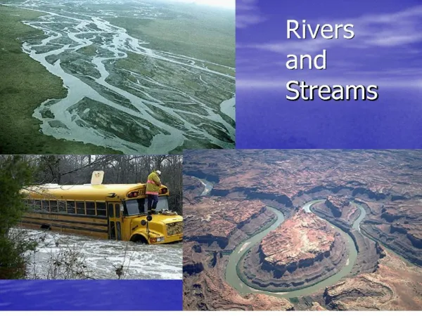
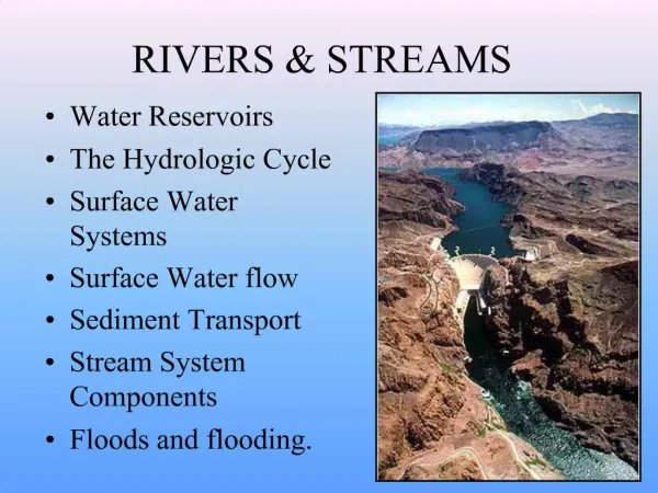
Rivers and Streams. Watershed. Total land area that drains surface water to a common point. River basin Drainage basin Catchment. separated topographically from adjacent basins by a geographical barrier such as a ridge, hill or mountain, which is known as a water divide.

E N D
Watershed Total land area that drains surface water to a common point. River basin Drainage basin Catchment separated topographically from adjacent basins by a geographical barrier such as a ridge, hill or mountain, which is known as a water divide.
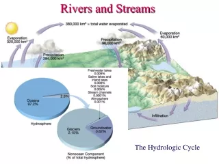
1/5 of rainwater falling a watershed collects directly in rivers overland soil flow Evaporation Groundwater Lakes Sinks Soil Water Wetlands 80%
Amazon Watershed World’s Largest Watershed ¾ the size of United States 2,720,000 sq mi 80 – 110 ‘’ rainfall/year
The Amazon largest river in the world by volume, with a total river flow greater than the next top ten largest rivers flowing into the ocean combined.
World Hydrology Mouth of Amazon Discharge: 319,000 m³ per sec. 20% of freshwater entering the oceans
Watershed Biodiversity 2,300,000 mi2 of rainforest 2.5 million insect species 2000 bird and mammal species 75,000 types of trees/km2 150,000 species of vascular plants/km2 1 in 5
10% of the world’s terrestrial primary productivity $6820/hectare (intact) $1000/hectare (clear cut) Accumulates 0.62 tons of Carbon per hectare per year $148/hectare (pasture) vanishing at a rate of 20,000 miles² per year Deforestation:releases 200 million metric tons of CO2/yr
Congo Watershed 1,335,000 mi2 700,000 mi2 of tropical rainforest Discharge: 41,800 m³/s 3,000 mi2 lost each year
confluence mouth Mississippi Watershed 1,151,000 sq mi Discharge: 12,800 m3/sec
Watershed Components 1,151,000 sq mi headwaters tributary Watershed (basin) confluence mouth Headwaters: the source of the river Mouth: end of river Confluence: the point where two rivers meet Tributary: a smaller river which flows into a larger river Length = headwaters to mouth
Total Length of the Longest Rivers Nile = 4135 miles Amazon = 3980 miles Yangtze = 3917 miles Mouth of Nile Mississippi/Missouri = 3902 miles Congo Flow is from headwaters to mouth by the force of gravity
River flow is due to gravity. Flow velocity strongly depends on the altitude of the headwaters in relation to the mouth
River Flow Rivers flow due to gravity. Flow velocity is quantified, in part, by differences in elevation over a lateral distance. This driving force for river flow is called a gradient. Δh source ΔL h mouth L
The Mississippi Source: Lake Itasca at 1475 feet Mouth: Gulf of Mexico at 0 feet
Gradient Mississippi : headwaters = 1475 ft mouth = 0 ft length = 2330 miles Lake Itasca New Orleans Δh = 1475 feet – 0 feet = 1475 ft. Elevation: ΔL = 2330 miles Length: Δh = 1475 ft = 0.63 ft/mi ΔL 2330 mi
Gradients of the Three Longest Rivers Lake Victoria Nile = 3721 ft= 0.9 ft/mile 4135 miles Andes Amazon = 16,962 ft = 4.24 ft/mile 3980 miles Tibet Plateau Yangtze = 16,542 feet = 4.17 ft/mile 3917 miles
Large Gradient Flow velocity is partly determined by the gradient Δh ΔL h mouth L Small Gradient Δh h ΔL mouth L
North Carolina Mountains 200 ft = 25 ft/mi 8.0 mi 1600 ft = 213 ft/mi 7.5 mi The gradient, in part, determines the flow velocity
The gradient of the river is a dominant factor In river flow velocity Constrictions increase velocity Bottom roughness decreases flow velocity Winding or meandering rivers tend to flow more slowly Length decreases velocity, but increases volume and width
Florida River Flow Apalachicola Suwannee St. Johns Kissimmee Generally sluggish flow
Florida 345 ft 98 ft 0 ft
St. Johns River “Laziest river in the world” 30 feet over 310 miles 0.096 ft/mile (1.16 in/mile)
Florida’s Rivers Source RiverlengthElevation Gradient St. Johns 310 miles 30 feet 1.16 in/mile Suwannee 266 miles 200 feet 9.02 in/mile Kissimmee 134 miles 14 feet 1.25 in/mile Apalachicola 112 miles 77 feet 8.25 in/mile Slow flow of contaminants
Floodplains Floodplain - area of relatively level land that is inundated from time to time by river flooding
Floodplain Productivity and Fertility Wetting of the floodplain soil releases a surge of nutrients Microscopic organisms thrive Larger species enter a rapid breeding cycle. Opportunistic feeders (particularly birds) move in The surge of new growth endures for some time. A floodplain can contain up to 1000 times as many species as a river Interaction of the river with the floodplain also can remove excess nutrients from the river
Floodplain Productivity: The Mekong and Tonle Sap
Mekong 17,139 ft Gradient: 5.7 ft/mile 12th longest China, Thailand, Cambodia, Laos, Vietnam The least modified major river in the world Characterized by seasonal pulses of monsoon water
Mekong River Lifeblood of S.E. Asia. 80% of Cambodia’s population is involved in fishing and processing. 60 million people in Laos, Cambodia, and Vietnam subsist on the river and its wetlands which yield approximately 2 million tons of fish per year: equal to 2% of the entire would catch of wild fish. The biological hearts of the river’s productivity are the Tonle Sap river and Tonle Sap Lake.
Tonle Sap Mekong Tonle Sap The Tonle Sap river is a tributary to the Mekong
Reversing its Flow Dry season from November to May Monsoon rains from June to September Mekong forces the tributary to flow backward into Tonle Sap Lake Absorbs 1/5 of the Mekong’s flood waters
1000 species of fish Trey Riel 60% of the Cambodians' protein intake Juvenile fry are swept into the flooded forests of the Tonle Sap and feed on floating vegetation Nets surround the entire lake And river floodplain.
The Kissimmee River floodplain utilization by waterfowl declined by 92%.
The Mississippi June, 2008 Levee Levee Levees Natural or artificial embankments paralleling the course of a river Prevent natural floodplain function
High flow Low flow Altered flow Triggers spawning migrations in fish and gives them access to the variety of habitats needed for reproduction, feeding and growth of their young allow diverse plant beds to develop and thrive, providing important habitat for fish and wildlife connection between the river and its floodplains is lost. Plant and animal diversity declines, water quality is degraded and the damaging effects of flooding are increased
Mekong 17,139 ft Gradient: 5.7 ft/mile Length: 3,000 mi The least modified major river in the world Characterized by seasonal pulses of monsoon water
Mekong River Lifeblood of S.E. Asia. 80% of Cambodia’s population is involved in fishing and processing. 60 million people in Laos, Cambodia, and Vietnam Subsist on the river and its wetlands which yield Approximately 2 million tons of fish per year Equals 2% of the entire world catch of wild fish The biological heart of the river’s productivity is in the Tonle Sap river.
Tonle Sap Mekong Tonle Sap The Tonle Sap river is a tributary to the Mekong
Reversing its Flow Monsoon rains in April to September Mekong forces the tributary to flow backward into Tonle Sap Lake Absorbs 1/5 of the Mekong’s flood waters
1000 species of fish Trey Riel 60% of the Cambodians' protein intake Juvenile fry are swept into the flooded forests of the Tonle Sap