Download
1 / 17
170 likes | 360 Vues
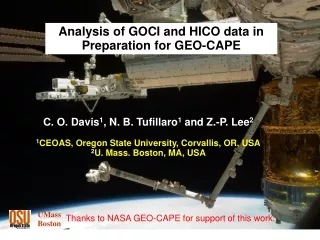
Analysis of GOCI data in Preparation for GEO-CAPE. Curtiss O. Davis 1 ZhongPing Lee 2 1 COAS, Oregon State University, Corvallis, OR 97331 USA cdavis@coas.oregonstate.edu 2 Geosystems Research Institute, Mississippi State University Stennis Space Center, MS 39529 zplee@ngi.msstate.edu.

E N D
Analysis of GOCI data in Preparation for GEO-CAPE Curtiss O. Davis1 ZhongPing Lee2 1COAS, Oregon State University, Corvallis, OR 97331 USA cdavis@coas.oregonstate.edu 2Geosystems Research Institute, Mississippi State University Stennis Space Center, MS 39529 zplee@ngi.msstate.edu
Outline of Presentation • Proposed GEOCAPE work to begin this summer • GOCI and GOCI data • HICO and HICO data • Planned analysis and products • Summary and conclusions
Proposed Activities In this project we will investigate the feasibility and utility of ocean color imaging from a GEO platform using imagery data from the first ever geostationary ocean color sensor. Specifically: • Obtain data from the Korean Geostationary Ocean Color Imager (GOCI) to evaluate its characteristics and calibration and then use it to evaluate: • Pointing stability requirements, • Improvement in measuring coastal dynamics with hourly data, • Radiometric sensitivity requirements for imaging early morning and late afternoon, • Improvement of daily or monthly climatology of bio-geophysical properties with multiple daily scans, • Temporal and spatial characteristics of Sun glint, and • Atmospheric and oceanic product quality.
Korean GOCI on COMS-1 In June 2010 the Korean Geostationary Ocean Color Imager (GOCI) was launched and it is providing the first ocean color imagery from geostationary orbit for a region around Korea, Japan and China. GOCI is a multispectral instrument imaging the region hourly during daylight hours. GOCI Image for April 12, 2011 from KOSC website
Cross-Calibration with LEO Ocean Color Sensors • Advantages of using Low Earth Orbit (LEO) ocean color sensors: • Can match data collection with GOCI coverage • Can match a full scene covering a variety of environments and sea truth locations. • LEO sensors use vicarious calibration and can transfer that advantage to GOCI • The challenge is to select the best sensor for matchup with GOCI: • Need to match channels to GOCI channels • Spectrometers easier to match to GOCI filter channels than other filter channel instruments. • Need to match Ground Sample Distance (GSD) and sampling locations • Smaller GSD that can be binned to GOCI GSD is a big advantage. • Most LEO sensors in sun-synchronous orbits – one match time of day • Non sun-synchronous orbit could provide matches at various times of day.
Cross Calibration with LEO Ocean Color Sensors Comparison of Spectral Channels
Cross Calibration with MERIS • MERIS continues to operate well and provide stable well calibrated data. http://envisat.esa.int/handbooks/meris/ • Operations officially extended to 2014. • Follow-on sensors planned for Sentinel 3 satellites to extend time series for decades. • Reasonable match between MERIS and GOCI channels. • MERIS is a high resolution spectrometer binned to the selected channels. • This approach gives regular channel shape and is more readily matched to GOCI filter shapes. • Can request MERIS 300 m GSD data to better match the GOCI pixel size. • MERIS is calibrated against BOUSOLLE buoy data. • Provides a calibration of the water leaving radiances. • Calibrates the combination of sensor calibration and atmospheric correction.
The Hyperspectral Imager for the Coastal Ocean (HICO) • HICO is an experiment to see what we gain by imaging the costal ocean at higher resolution from space. • The HICO sensor: • first spaceborne imaging spectrometer designed to sample coastal oceans • samples coastal regions at <100 m (380 to 1000 nm: at 5.7 nm bandwidth) • has high signal-to-noise ratio to resolve the complexity of the coastal ocean • Sponsored as an Innovative Naval Prototype (INP) of Office of Naval Research - built and delivered in 16 months. • Supported by the Space Test Program for Integration and Launch • Additional support from NASA and JAXA for launch and integration onto the Japanese Experiment Module Exposed Facility on the International Space Station (ISS) Left, HICO, before integration into HREP. Right red arrow shows location of HREP on the JEM-EF. HICO is integrated and flown under the direction of DoD’s Space Test Program
HICO attached to the JEM-EF on the ISS HICO Viewing Slit
HICO Image of Pusan, South Korea: 11/18/09 HICO Data Google Earth North
HICO Data Distribution at OSU • Developed HICO Public Website at OSU using published and approved for distribution data, publications and presentations. • Includes example HICO data. • OSU HICO Web site will be portal for data requests and distribution • Data requests require a short proposal and data agreement signed by the requestor and their institution and approved by NRL. • Example data and data requested by that user will be available to them. • http://hico.coas.oregonstate.edu • Full description of the data and directions for use on the website
Cross Calibration with HICO • The Hyperspectral Imager for the Coastal Ocean (HICO) operating on the International Space Station since September 2009. • Advantages • HICO is an imaging spectrometer can directly match GOCI channels. • HICO has 100 m GSD; can bin pixels to accurately match GOCI pixels. • HICO on ISS 52 deg. orbit - not sun-synchronous. • Image at all times of day to match GOCI. • Look at changes in phytoplankton, chlorophyll, fluorescence and CDOM production as a function of time of day. • Disadvantage - HICO is a new sensor launched in September 2009. • HICO does not have the calibration history that MODIS and MERIS have. • HICO will be cross-calibrated with MODIS and MERIS. • HICO will do vicarious calibration using MOBY and SeaPRISMs.
GOCI and HICO data HICO image of Han River, 24 September 2010: Left,100 meter native resolution. Right, binning to 500 meter (GOCI) resolution.
Planned initial GOCI data Analysis • Collect simultaneous GOCI and HICO data. • If possible chose images to include sea truth by other GOCI investigators. • Remap HIOC data and calculate channels to match GOCI data. • Compare water leaving radiances and chlorophyll or other standard products, including comparisons with sea truth where available. • Analyze time series and look for changes with time of day. • Collect simultaneous MERIS 300 m and GOCI data. • Remap MERIS data and calculate channels to match GOCI data. • Compare water leaving radiances and chlorophyll or other standard products. • Ideally collect simultaneous GOCI, HICO and MERIS data with sea truth. • Analysis should provide verification of GOCI Calibration. • If data supports it suggest possible adjustments to GOCI team.
Summary • First GOCI data available • Initial analysis to include cross calibration with MERIS and HICO. • MERIS is a well calibrated stable sensor. • HICO data better for cross-calibration with GOCI data. • Spectral data binned to match GOCI. • 92 m GSD can bin to GOCI pixels. • Looking forward to analyzing GOCI data over the next year to assess the advantages of Geostationary data in preparation for GEOCAPE GOCI Image for April 12, 2011 from KOSC website
Chlorophyll Comparison of HICO to MODIS (Aqua) Nearly coincident MODIS and HICOTM images of the Yangtze River, China taken on January 18, 2010. Left, MODIS image (0500 GMT) of Chlorophyll-a Concentration (mg/m3) standard product from GSFC. The box indicates the location of the HICO image relative to the MODIS image. Right, HICOTM image (0440 GMT) of Chlorophyll-a Concentration (mg/m3) from HICOTM data using ATREM atmospheric correction and a standard chlorophyll algorithm. (Preliminary Results by R-R Li and B-C Gao.)
Image location 50 km Radiometric Comparison of HICO to MODIS (Aqua) Nearly coincident HICO and MODIS images of turbid ocean off Shanghai, China demonstrates that HICO is well-calibrated HICO Date: 18 January 2010 Time: 04:40:35 UTC Solar zenith angle: 53 Pixel size: 95 m MODIS (Aqua) Date: 18 January 2010 Time: 05:00:00 UTC Solar zenith angle: 52 Pixel size: 1000 m Top-Of-Atmosphere Spectral Radiance East China Sea off Shanghai R.-R. Li, NRL