Download
1 / 16
190 likes | 444 Vues
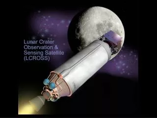
National Aeronautics and Space Administration Jet Propulsion Laboratory California Institute of Technology Pasadena, California. Goldstone Radar Support for LCROSS Evaluation of Impact Sites. Martin Slade October 16, 2006. Outline. The Goldstone Solar System Radar (GSSR)

E N D
National Aeronautics and Space Administration Jet Propulsion Laboratory California Institute of Technology Pasadena, California Goldstone Radar Support for LCROSS Evaluation of Impact Sites Martin Slade October 16, 2006
Outline • The Goldstone Solar System Radar (GSSR) • GSSR Imaging and Topography • Past GSSR Measurements of the Lunar Poles • Completed Measurements of the Lunar Poles • Future Options Possible in Support of LCROSS • Summary
A unique NASA facility for high-resolution ranging and imaging of planetary and small-body targets One transmitting, multiple receiving antennas for interferometry 500 kW X-band transmitter Very sensitive maser receiver Provides a wide variety of information Simultaneous, co-registered radar image and topography - even in Lunar unlit areas Surface characteristics, structure and composition Orbits, rotations, spin axis Leverages DSN assets for radar Mission support and radar science Deep Space Network (DSN) primary function is communication and nav for space missions beyond low Earth orbit The Goldstone Solar System Radar(GSSR)
Past GSSR Observations of Lunar Poles • 1997 GSSR observations providedthe highest resolution topographic maps and images to dateof the permanently shadowed regions at the lunar poles • Pixel size 150 m x 150 m • Height resolution 50 m • Datum: 1738.0 km sphere • Used by Lunar Prospector in planning impact into Shoemaker Crater (Images: Margot et al., Science, volume 284, 1999)
Radar “Backscatter” Image vs. Optical Image (Image: Margot et al., Science, vol. 284, 1999) Ref.:http://www.lpi.usra.edu/publications/slidesets/clem2nd/slide_31.html • Radar resolution 150 m; Clementine resolution variable - average ~200 m • Radar image provides details in areas without solar illumination • Radar simultaneously provides co-registered topography and imagery
Permanently Shadowed Regions of Lunar South Pole Craters of note are Shoemaker, Faustini, de Gerlache, Shackleton,and an unnamed crater at ~(0,-87.5) (Image: Margot et al., Science, vol. 284, 1999)
Radar “Backscatter” Image of Lunar South Pole at 150-meters/pixel Large “old” craters with a good radar view of a substantial fraction of their floors are marked.
Goldstone Radar Data Acquisition on Sept. 13 for Lunar South Pole • New radar swath just obtained on Sept.13; Processing underway • ~20-meter resolution pixels topography + heights & ~20-meter resolution radar backscatter maps expected to be delivered in a few months
Additions and Enhacements Possible in time to benefit LCROSS • Additional 19-m resolution radar images/topography • More swaths can be obtained reliably and at low cost • Reduction to topography/radar backscatter images at modest cost • Image any area of interest on lunar Nearside -landing site(s) early planning • Crater wall steepness and rms terrain roughness -- rover accessibility • 4.5-m resolution could be extended to lunar polar measurements • Currently demonstrated on asteroids and lunar subradar point • Requires development of enhanced transmitter modulation for poles • 4x in resolution - may enable detection ~20-m LCROSS impact crater • Enhancement to 1-3 m resolution is under consideration • Requires development of broader bandwidth transmitter klystrons • Human-scale measurement of local surface roughness and slopes • Detailed characterization of landing sites and surface excursion planning • Near-grazing incidence angles limits Earth-based polar coverage, but still worthwhile for Malapert Mountain Earth relay site and many other sites
1997 ground-based radar from the DSN site at Goldstone, CA, has produced the highest resolution topography and imaging to date of the lunar poles (150-m pixels, 50-m height resolution) Post-1997 enhancements to this facility provide ~ 19-m spatial and topographic resolution of the lunar surface Ongoing processing of measurement of the south polar region Future options with benefit to the lunar exploration program Measure other areas of interest anywhere on lunar Nearside Extend new 4.5-m capability to image lunar polar and other regions Develop 1-m capability to characterize surface at human-scale Summary
Tycho Crater: A Comparison of Radar DEM With Clementine LIDAR Dots are Clementine LIDAR measurements Continuous curve is Radar topography along the Clementine “ground” track Radar image of Tycho crater (greyscale) and Radar Digital Elevation Map (DEM) [color]
South Polar Illumination-Bussey et al., 1999 High-light-time peaks will be better defined by higher resolution topography
Overview of Processing Image 2 Image 1 Unwrap phase (remove 360º ambiguities) (Source: A. Heim, Processing of SAR Data, Springer, 2004.) Topography
Complete Goldstone Radar Coverage in 1997 for Lunar South Pole (1738 km datum) 300 km 300 km 1200 km 1997 Radar South Pole mosaics giving coverage inclusive of Clementine LIDAR altimetry. Grid has 5 degree latitude increments (30 km/degree). [J.-L. Margot Cornell Ph.D. thesis] Without topography including LIDAR altimetry, absolute topography might be difficult.
Goldstone Radar Swaths needed toreproduce 1997 South Pole coverage Since the resolution has decreased from 150 meters/pixel to ~20 meters per pixel, each swath requires about 10 times longer integration time, even with +10 dB SNR.