Download

1 / 1
10 likes | 136 Vues
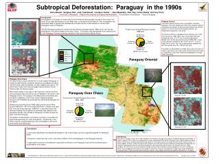
Forest in 2001. Deforestation 1991 - 2001. Forest. Nonforest. Deforestation. Within Reserve. 10 km buffer surrounding Reserve. Forest in 1999. Deforestation 1989 - 1991. Within Park. 10 km buffer Surrounding Park. Forest in 1999. Deforestation 1989 - 1999. Within Reserve.

E N D
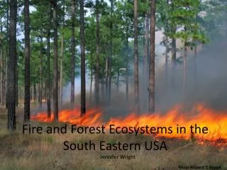
Forest in 2001 Deforestation 1991 - 2001 Forest Nonforest Deforestation Within Reserve 10 km buffer surrounding Reserve Forest in 1999 Deforestation 1989 - 1991 Within Park 10 km buffer Surrounding Park Forest in 1999 Deforestation 1989 - 1999 Within Reserve 10 km buffer surrounding Reserve 0 25 50 100 Kilometers Change in the Subtropical Forest of Eastern Paraguay in the 1990s Alice Altstatt1, Sunghee Kim1, Oscar Rodas4, Alberto Yanosky4, John Townshend1, Compton Tucker1,2, Rob Clay4 and John Musinsky3 1University of Maryland, 2National Aeronautics and Space Administration, 3Conservation International, 4Guyra Paraguay Introduction Investigations of changes in forest cover in South America have typically focused on the tropics, but much of the rapid deforestation in the 1990s was in subtropical South America. This investigation has generated rates of change and identified the principal causes of deforestation in Paraguay using remotely sensed data from the Landsat satellites. The Rio Paraguay bisects the country into two distinct ecological regions. West of the river are dry woodlands on the alluvial plains of the Gran Chaco. The results presented here are for the geologically more varied terrain of the eastern half of Paraguay where the dominant forest type is the humid subtropical Atlantic Forest of the Upper Parana. Forest Cover Change Eastern Paraguay 1989-2001 Mbaracayu Forest Biosphere Reserve Study Area 140,234 km2 Nonforest 95,217 km2 Forest 31,463 km2 Mbaracayu is one of the most important humid subtropical forest tracts in South America. It is threatened by nearby large scale forest conversion to agriculture, encroachment by rural settlers, as well as small scale forest degradation within the protected area boundaries. Deforestation 13,555 km2 (30.1% loss of forest) November 18, 1991 10 km Caaguazu National Park PARAGUAY Parana Rio Two patterns of forest conversion are occurring in close proximity to Caaguazu. To the north, large tracts of forest have been converted to soybean agriculture. To the south and west, rural settlers have established small farms in the forest resulting in a recognizable linear pattern of clearings. Water Cloud Cloud Protected Area April 19, 1989 10 km September 18, 2001 BRAZIL San Rafael Managed Resource Reserve ARGENTINA San Rafael contains one of the largest remaining tracts of Atlantic Forest in Paraguay. It has been designated as a sustainable use area. Forest conversion within the protected area boundaries is apparent in the Landsat imagery. August 5, 1999 Forest Cover Change in Eastern Paraguay The Upper Parana Atlantic Forest once covered 85% of eastern Paraguay. This semi-deciduous moist forest contains many endemic subtropical tree species as well as some tropical and cerrado species. It is one of the most biologically diverse, yet threatened ecosystems in the world. Cerrado and riverine forest types also occur in eastern Paraguay and are included in this forest cover change analysis. Significant forest cover conversion occurred in eastern Paraguay during the 1980s. Forest continues to disappear in this region at an alarming rate. In the first time period (1989-1991), 32% of the study area was covered by forest (~45,000 km2 of a total study area of 140,234 km2). By the second time period (1999-2001), forest cover had been reduced to 22% of the study area (~31,500 km2 - a loss of 13,555 km2 of forest). The rate of deforestation for eastern Paraguay between the two time periods was 1100 - 1350 km2 per year. The pattern of deforestation includes large scale conversion of forest to agricultural use, small scale encroachment into forest by rural settlers, and forest clearing and degradation through timber harvesting. April 19, 1989 10 km Paraguay Rio August 5, 1999 • Conclusions • Large scale conversion of forest to agriculture continued in Paraguay during the 1990s, yet large blocks of Atlantic Forest still remain in eastern Paraguay, within protected areas, but also outside existing protected area boundaries. • A relatively small amount of forest conversion occurred inside protected areas despite significant deforestation outside the boundaries, indicating that protected area status facilitates forest conservation. • Forest cover in subtropical areas can be effectively monitored and measured on a large scale by processing Landsat imagery using procedures developed for tropical areas. Acknowledgements: This study was funded under NASA’s Land Cover Land Use Change Program, Grant NAG5-9337 Improvements in Landsat Pathfinder Methods for Monitoring Tropical Deforestation and their Extension to Extra-Tropical Areas and NCC5300 University of Maryland Land Cover Earth Science Information Partnership. The Global Land Cover Facility http://glcf.umiacs.umd.edu