Download
1 / 18
250 likes | 856 Vues
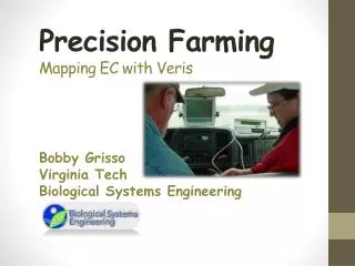
Soil EC Mapping. Casey Andrews SOIL 4213 April 22, 2009. Crop Inputs. Historically, crop inputs were applied evenly over a field. Seed, irrigation, fertilizer, and pesticides. However, yields at the end of the growing season can vary greatly. Many factors affect crop yield.

E N D
Soil EC Mapping Casey Andrews SOIL 4213 April 22, 2009
Crop Inputs • Historically, crop inputs were applied evenly over a field. • Seed, irrigation, fertilizer, and pesticides. • However, yields at the end of the growing season can vary greatly. • Many factors affect crop yield. • Soil texture, organic matter, salinity, subsoil characteristics, and water holding capacity.
How Do We Optimize Input Returns? • Different amounts of agricultural inputs must be added to different soils. • Management zones must be established • Soil maps • Soil tests • Satellite images • Soil electrical conductivity maps
What is Soil Electrical Conductivity? • Soil is an electrical conductor • Soil EC measures how easily an electrical current flows through the soil. • Factors that affect soil EC • Salt concentration • Soil composition • Amount of sand, organic matter, and water content.
In 1997, Veris Technologies began producing Soil EC mapping systems. One of the simplest devices to measure soil EC in the field. Soil EC measurements have been used since the early 1900’s-Veris mobilized the process and added GPS. Veris Soil EC Mapping System
How Does it Work? • As the Veris EC cart is pulled through the field, one pair of coulter-electrodes injects a known voltage into the soil, while the other coulter-electrodes measure the drop in that voltage. The result: a detailed map of the soil texture variability in the crop rooting zone.
Soil Testing Depth • Two models • Veris 3100 • Uses two arrays • 1st - 0 to 1 foot • 2nd – 0 to 3 feet • Veris 2000XA • Uses only one array • Adjustable from 0-2 feet to 0-3 feet
Speed of Use • A field is usually mapped by driving the entire field on parallel paths from 40 to 60 feet. • Operation speed ranges between 8 and 15 mph. • Depends on terrain and field roughness. • Veris records 50 to 100 soil EC readings per acre. • An 150 acre pivot can be mapped in 5 to 8 hours.
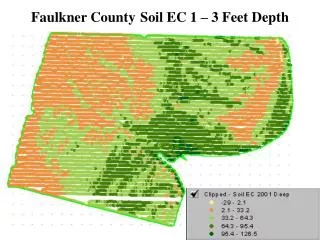
Soil EC Maps • The differences between the soil EC zones in a field are caused by differences in the soil’s composition (e.g., the amount of sand, clay, and organic matter). • A soil EC map simply shows how soil composition changes across the field, as highlighted by different shades of color for soil EC zones.
Soil EC Maps • Research shows that in most fields, zones with higher EC values have higher clay and organic matter contents than lower EC zones. • It is always a good idea to collect a few soil cores from each of the EC zones to determine the amounts of sand, clay and organic matter in each zone
Soil EC Maps • Three to five soil cores (in 1 to 3 foot depths) taken from different locations in each EC zone are sufficient to determine the level of sand, clay and organic matter in each zone. • The light colored areas in the soil EC map (or the areas that have low EC values) are usually high in sand and low in clay and organic matter. • The darker colored areas on the soil EC map (or the areas with higher EC values) have more clay and organic matter and less sand.
Using Soil EC to Improve Crop Management Decisions • Farmers want to know the composition of their soil so they can apply the correct amount of seeds, fertilizers, and irrigation to each section of their field. • Knowing the pattern of soil composition across the field helps farmers and consultants tailor their soil and crop management decisions to fit the soil pattern rather than assuming that the whole field has a uniform composition.
Economic and Agronomic Advantages in Using Soil EC • Rapid identification of farm field variability. • Guidance to smart soil sampling as opposed to random or grid-based soil sampling. • Logical placement and interpretation of on-farm tests. • Development of potential “management zones” for variable rate seeding and chemical application.
Economic and Agronomic Advantages in Using Soil EC Identification of coarse-textured zones within the field that are susceptible to leaching. Identification of coarse-textured zones within the field that have low water holding capacity and thus susceptible to crop water stress. Identification of crop productivity zones based on relative clay and organic matter contents; and Further improvement in USDA-NRCS soil maps for various on-farm management decisions.
One Time Investment • Research shows that soil EC changes as soil-water content changes, but the patterns of a soil EC map stay unchanged from year to year. • Soil EC patterns do not change much over time because these soil properties are relatively constant. • Therefore, a single soil EC map of a field is sufficient for many years.
Conclusion • Mapping soil composition across the field is easily done using measurements of soil electrical conductivity. • A soil EC map is important because it identifies areas in a field that have different soil compositions which may benefit from different management strategies. • Soil properties are relatively constant, a single soil EC map of a field is sufficient for many years.
References Farahani H. J. , R. Khosla and G.W. Buchleiter. (2007). Field EC Mapping: A New Tool to Make Better Decisions. Colorado State University Extension. http://www.ext.colostate.edu/pubs/crops/00568.html www.veristech.com/products/soilec.aspx