Download
1 / 18
180 likes | 351 Vues
NATIONAL CENTERS FOR ENVIRONMENTAL PREDICTION. Verification of NHC Forecasts of Extratropical Transition. JACK BEVEN. TROPICAL PREDICTION CENTER NATIONAL HURRICANE CENTER. WHERE AMERICA’S CLIMATE AND WEATHER SERVICES BEGIN. What is extratropical transition?. My conceptual model.

E N D
NATIONAL CENTERS FOR ENVIRONMENTAL PREDICTION Verification of NHC Forecasts of Extratropical Transition JACK BEVEN TROPICAL PREDICTION CENTER NATIONAL HURRICANE CENTER WHERE AMERICA’S CLIMATE AND WEATHER SERVICES BEGIN
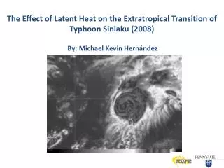
What is extratropical transition? My conceptual model ET is the process by which a tropical cyclone loses tropical characteristics in a baroclinic environment. This can end in a variety of cyclone structures. Hart and Evans Cyclone Phase Space
Why are analyzing and forecasting extratropical transition important? • Tropical cyclones undergo significant structural changes during ET, which can include (re-)intensification, expansion of the wind field, and modified precipitation distribution (all seen in Noel of 2007) • Forecast/warning procedures differ greatly for tropical and non-tropical cyclones
Hurricane Lili (1996) “Obviously we have little skill with Lili in forecasting extratropical transition” – Lixion Avila
Verification for ET Forecasts • Based on yes-no 2-D contingency diagram based on whether ET occurred/was forecast at any time in the forecast period • Two versions: One includes forecasts for all TCs, while the other includes only TC where ET was forecast and/or did occur – both versions done for 5-day and 3-day forecasts • Includes verification of the timing of the ET forecast – how wrong temporally was the forecast of ET when ET occurred
Verification Table for 2005 ET Observed ET Forecast
Verification does not include… • Forecast track, intensity, or wind radii of the cyclone during the extratropical phase
3-Day Individual Time Errors Mean ET Forecast Error (hr)
3-Day Individual Time Biases Mean ET Forecast Bias (hr)
Methodology Issues • TPC discrete forecast intervals and timing • Possible best track inconsistencies in determining if transition occurred and transition time, especially before the development of the cyclone phase space • Forecasts of system becoming ET, then no actual forecast positions as an ET cyclone
Issues with Storms • Systems that dissipated upon merging with fronts (Cindy 1999, Florence 2000, Cristobal 2002, Kyle 2002, TD14 2002, Irene 2005) • Track forecast problems (Katrina 1999, Gamma 2005, Gordon 2006) • Intensity forecast problems (Mindy 2003, Bonnie 2004, Debby 2006) • Aborted transitions (Alberto 2000) • Slow or interrupted transitions (Lili 1996, Gabrielle 2001, Maria 2005, Helene 2006) • Unclimatological transitions (Michelle 2001) • Unclimatological non-transitions (Humberto 2001, Juan 2003) • Transitions or lack thereof over mid-America (Lili 200, Ivan 2004, Arlene 2005, Katrina 2005) • Environmental mis-reads? (Henri 2003, Hermine 2004, Matthew 2004, Philippe 2005, Epsilon 2005)
Conclusions • NHC forecasts of extratropical transition for the most part have skill according to the measures of the 2-D contingency table verification • ET forecasts have shown a general increase in quality since 1996. This is likely due to better NWP models, as well as the introduction of the Hart and Evans Cyclone Phase Space diagrams