Download
1 / 1
10 likes | 183 Vues
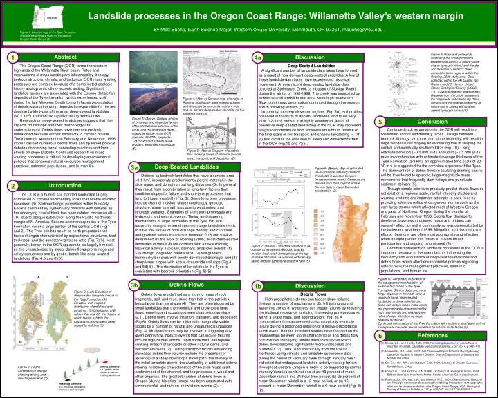
Landslide processes in the Oregon Coast Range: Willamette Valley’s western margin. By Matt Buche, Earth Science Major, Western Oregon University, Monmouth, OR 97361, mbuche@wou.edu. Figure 1: Location map of the Tyee Formation (Eocene sedimentary rocks) in the central Oregon Coast Range (5).

E N D
Landslide processes in the Oregon Coast Range: Willamette Valley’s western margin By Matt Buche, Earth Science Major, Western Oregon University, Monmouth, OR 97361, mbuche@wou.edu Figure 1: Location map of the Tyee Formation (Eocene sedimentary rocks) in the central Oregon Coast Range (5). 1 4a Figure 9: Rose and polar plots illustrating the correspondence between the aspect of failure-prone slopes (gray pie slices) and the dip and direction of bedrock (filled circles) for three regions within the Roering, 2005 study area. Data collected within the (A) Gunter, (B) Walton, and (C) Horton, United States Geological Survey (USGS) 7.5” 1:24k topographic quadrangles. Distance from the origin represents the magnitude of bedrock dip (filled circles) and the relative frequency of failure-prone slopes with a given aspect (gray pie slices) (5). Abstract Discussion The Oregon Coast Range (OCR) forms the western highlands of the Willamette River basin. Rates and mechanisms of mass wasting are influenced by lithology, bedrock structure, climate, and tectonics. OCR mass wasting processes are complex because of a complicated geologic history and dynamic climo-tectonic setting. Significant landslide terrains are associated with the Eocene deltaic fan deposits of the Tyee formation, which experienced uplift during the late Miocene. South-to-north facies progradation of deltaic-submarine ramp deposits is responsible for the two dominant slide types of the area: deep-seated landslides (>0.1 km2) and shallow, rapidly moving debris flows. Research on deep-seated landslides suggests that their impacts on hillslope and river morphology are underestimated. Debris flows have been extensively researched because of their sensitivity to climatic drivers. The inclement weather of the February and November, 1996, storms caused numerous debris flows and spawned political debates concerning forest harvesting practices and their effects on slope stability. Continued research on mass wasting processes is critical for developing environmental policies that conserve natural resources management practices, salmonid populations, and human life. Deep Seated Landslides A significant number of landslide-dam lakes have formed as a result of now dormant deep-seated landslides. A few of these landslide-dam lakes have experienced historical movement. A more recent deep-seated landslide-dam occured at Steinhauer Creek (a tributary of Siuslaw River) during the winter of 1998-1999. The creek was inundated by a deep-seated landslide that left a 30-m-high headscarp. Slow, continuous deformation continued through the season and in following winters (5). In contrast to steep dissected regions (Fig. 5A), soil profiles observed in roadcuts of ancient landslides tend to be very thick (>2-3 m), dense, and highly weathered. Areas of pervasive deep-seated landsliding in the OCR may represent a significant departure from erosional equilibrium relative to the time scale of soil transport and shallow landsliding (~ 104 yr) that dictates the evolution of steep and dissected terrain in the OCR (Fig.10 and 7)(5). Figure 4: (Above) Contour map of a ridge in Roering, 2005 study area exhibiting steep and dissected terrain on its northern side and an ancient deep-seated landslide on the southern flank (5). Figure 5: (Above) Oblique photos of (A) steep and dissected terrain often cited as characteristic of the OCR, and (B) an ancient deep-seated landslide in the OCR (latitude: 43.47oN, longitude: 124.12oW) that exhibits a low-gradient, benchlike morphology (5). 5 Conclusion Continued rock exhumation in the OCR will result in a southward shift of sedimentary facies.Linkage between bedrock lithology, structure, and slope instability, will result in large slope failures playing an increasing role in shaping the central and eventually southern OCR (Fig. 10). Using estimated erosion (~0.1 mm yr-1) and uplift (~1-5 mm yr-1) rates in combination with estimated average thickness of the Tyee Formation (2-3 km), an approximated time scale of 20-30 m.y. is suggested for the complete exposure of the Tyee. The dominant roll of debris flows in sculpting draining basins will be transferred to episodic, large-magnitude mass movements that frequently dam valleys and punctuate sediment delivery (5). Though simple criteria to precisely predict debris flows do not exist on a regional scale, rainfall intensity studies and warning systems are important attempts to save lives by providing advance notice of dangerous storms such as the very large storms which affected most of Western Oregon and parts of Northeast Oregon during the months of February and November 1996. Debris flow damage to dwellings, business structures, roads and bridges can severely affect an entire community as was demonstrated by the inclement weather of 1996. Mitigation and risk-reduction efforts, therefore, are often most appropriate and effective when multiple parties join forces to ensure broad participation and ongoing commitment (2). Continued research on landslide processes in the OCR is important because of the many factors influencing the frequency and occurrence of deep-seated landslides and debris flows which affect environmental policies regarding natural resource management practices, salmonid populations, and human life. Figure 6: (Above) Diagram of a debris flow showing zones of intitiaion (source area), transport, and deposition (2). 3a Deep-Seated Landslides Defined as bedrock landslides that have a surface area >0.1 km2, incorporate predominantly parent material in the slide mass, and do not run out long distances (5). In general, they result from a combination of long-term factors that condition slopes for failure and short-term processes that tend to trigger instability (Fig. 3). Some long term processes include channel incision, slope morphology, geologic structure, shear strength loss due to weathering, and lithologic variation. Examples of short term processes are hydrologic and seismic events. Timing and triggering mechanisms of large landslides in the Tyee Fm. are uncertain; though the terrain prone to large landslides tends to have low values of both drainage density and curvature and gradient values that cluster between 0.16 and 0.44 as determined by the work of Roering (2005). Most deep-seated landslides in the OCR are dormant with a few exhibiting historical activity. Typically, dormant landslides exhibit: (1) >10-m-high, degraded headscarps, (2) low gradient, hummocky benches with poorly developed drainage, and (3) steep lower slopes with active streamside soil slips (Fig.4 and 5B)(5) . The distribution of landslides in the Tyee is consistent with bedrock orientation (Fig. 9)(5). Figure 8: (Below) Map of estimated 24-hour rainfall intensity-duration thresholds in western Oregon (measurements in cm). Contours are derived from the Oregon Climate Service data of mean December precipitation (2). 2 Introduction The OCR is a humid, soil mantled landscape largely composed of Eocene sedimentary rocks that overlie volcanic basement (3). Sedimentologic properties within the early Eocene sedimentary system vary primarily with latitude, as the underlying crustal block has been rotated clockwise 40۫-70۫ due to oblique subduction along the Pacific Northwest margin of N. America. Eocene sedimentary rocks of the Tyee Formation cover a large portion of the central OCR (Fig.1 and 2). The Tyee exhibits south-to-north progradational facies changes characterized by depositional structures, bed thickness, and the sandstone:siltstone ratio (Fig. 7)(5). Most generally, terrain in the OCR appears to be largely bimodal, as it is characterized by steep, debris flows-prone ridge and valley sequences and by gentle, bench-like deep-seated landslides (Fig. 4,5 and 6)(5). Figure 7: (Above) Latitudinal variation in (A) fraction of terrain with B>0.33, and (B) median local relief. Annotations at the top illustrate latitudinal variation in sedimentary facies and the sandstone:siltstone ratio (5). A B Figure 10: Schematic illustration of the topographic manifestation of sedimentary facies of the Tyee Formation. Silt-rich distal and ramp fringe deposits in the north tend to generate large, deep-seated landslides and low-relief terrain. Sand-rich deltaic facies in the south are predominantly characterized by high relief terrain and relatively low rates of slope alteration by large, bedrock landslides. 3b Debris Flows 4b Discussion Debris flows are defined as a moving mass of rock fragments, soil, and mud, more than half of the particles being larger than sand size (4). They are often triggered by small landslides that then mobilize and grow to be large flows, entering and scouring stream channels downslope (2,1). Debris flows involve initiation, transport, and deposition (Fig.6). Debris flows can be initiated in marginally stable slopes by a number of natural and unnatural disturbances (Fig. 3). Multiple factors may be involved in triggering any given debris flow. Natural events that can induce failures include high-rainfall storms, rapid snow melt, earthquake shaking, breach of landslide or other natural dams, and volcanic eruptions (2). During transport factors influencing increased debris flow volume include the presence (or absence) of a steep downslope travel path, the mobility of the initial landslide debris, the availability of additional debris, internal hydrologic characteristics of the slide mass itself, confinement of the channel, and the presence of wood and other organics. The greatest number of debris flows in Oregon (during historical times) has been associated with severe rainfall and rain-on-snow storm events (2). Debris Flows High-precipitation storms can trigger slope failures through a number of mechanisms (2). Infiltrating ground water into zones of weakness can trigger failures by reducing the frictional resistance to sliding, increasing pore pressures within a slope mass, and adding weight (Fig. 3). A combination of the above mechanisms typically results in failure during a prolonged duration of a heavy-precipitation storm event. Rainfall threshold studies have focused on the relationships between storm characteristics and debris flow occurrences identifying rainfall thresholds above which debris flows become significantly more widespread and numerous (2). Data used specifically from the Pacific Northwest using climatic and landslide occurrence data during the period of February 1996 through January 1997 indicated that widespread landslide activity in steep terrain throughout western Oregon is likely to be triggered by rainfall intensity/duration combinations of (a) 40 percent of mean December rainfall in a 24-hour time period, (b) 25 percent of mean December rainfall in a 12-hour period, or (c) 15 percent of mean December rainfall in a 6-hour period (Fig. 8) (2). Figure 2: (Left) Elevation of deep-seated landslide terrain in the Tyee Formation. (A) Elevation with mapped distribution of anticlines and synclines. (B) Distribution of B values that quantify the degree to which terrain exhibits the topographic signature of deep-seated landsliding (5). Continued exhumation of the Tyee Formation will result in a southward shift of slide-prone, low-relief terrain underlain by silt-rich distal facies (5). 6 References (1) Benda, L.E., and Cundy, T.W., 1990, Predicting deposition of debris flows in mountain channels: Canadian Geotechnical Journal, v. 27, no. 4, p. 409-417. (2) Hofmeister, R.J., et al., 2002, GIS Overview Map of Potential Rapidly Moving Landslide Hazards in Western Oregon: Oregon Department of Geology and Mineral Industries. (3) Orr, E.L., Orr, W.N., and Baldwin, E.M., 1992, Geology of Oregon: Dubuque, Kendall/Hunt, 254 p. (4) Robert, B.L., and Jackson, J.A. (1984). Dictionary of Geological Terms, Third Edition, New York, New York: Anchor Books: American Geological Institute. (5) Roering, J.J., Kirchner, J.W., and Dietrich, W.E., 2005, Characterizing structural and lithologic controls on deep-seated landsliding: Implications for topographic relief and landscape evolution in the Oregon Coast Range, USA: Geological Society of America Bulletin, v. 117, p. 000-000: doi: 10.1130/B25567.1. Driving Elements e.g., gravity, water pressure, seismic shaking, windthrow Figure 3: (Right) Schematic of a slope, showing driving and resisting elements (2). Resisting Elements e.g., frictional resistance, cohesion, root strength