Download
1 / 80
800 likes | 807 Vues
This article discusses the background and definitions of Mesoscale Convective Systems (MCS) and Derechos, including their size, structure, and associated weather patterns. It explores the role of cold pools, rear-inflow jets, and line-end vortices in the evolution and intensification of these systems. Additionally, it compares the environmental characteristics of two high-end Derecho events, highlighting the differences in their mechanisms and factors contributing to their formation.

E N D
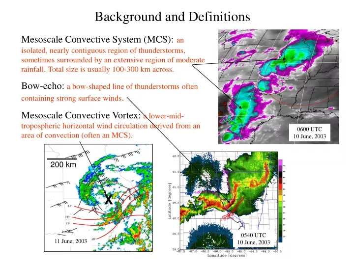
X Background and Definitions Mesoscale Convective System (MCS):an isolated, nearly contiguous region of thunderstorms, sometimes surrounded by an extensive region of moderate rainfall. Total size is usually 100-300 km across. Bow-echo:a bow-shaped line of thunderstorms often containing strong surface winds. Mesoscale Convective Vortex: a lower-mid-tropospheric horizontal wind circulation derived from an area of convection (often an MCS). 0600 UTC 10 June, 2003 200 km 0540 UTC 10 June, 2003 11 June, 2003
Basic Equations: 2D Squall Line ⁄ *Also, no vortex tilting or stretching -- Or, more simply, consider the 2D horizontal vorticity equation: where
RKW Theory Rotunno et al. (JAS, 1988) C/∆u > 1 “Optimal”condition for cold pool lifting C/∆u = 1 C/∆u < 1
2D Convective System Evolution: C/∆u << 1 C/∆u ~ 1 C/∆u > 1 Weak shear, strong cold pool: rapid evolution Strong shear, weak cold pool: slow evolution
RKW Theory: all other things being equal (e.g., same external forcing), squall line strength/longevity is “optimized” when the circulation associated with the system-generated cold pool remains “in balance” with the circulation associated with the low-level vertical wind shear. Issue:Squall-lines are observed to be strong and long-lived for a wider range of environments than suggested by the models (e.g., weaker shears, deeper shears,….). “Optimality” depends on metric being applied… e.g., updraft strength, rainrate, total rainfall, maximum surface winds....
How can we systematically produce the observed line-end vortex pattern?
Line-end vortex mechanisms: Mature Phase:
⁄ Vertical Vorticity: ⁄ …flux form ⁄ Circulation:
⁄ ⁄
…tilting of system-generated horizontal vorticity Rear-inflow jet (Davis and Weisman, 1994; Weisman and Davis, 1998; Davis and Galarneau, 2009)
Role of Line-End Vortices Focuses and Intensifies Rear-Inflow Jet
f-flux ⁄ f-flux
Derechos: Severe Lines of Thunderstorms • Damage from straight-line wind • Long swaths (> 400 km), long duration (> 6 h) • Wide damage swaths (100-500 km) • Rapid movement: 20-30 m/s Earthsky.org NOAA Storm Prediction Center Csmonitor.com
Derecho: (Johns and Hirt 1987) Large CAPE Moderate Shear
29 June 2012 Derecho: Composite Radar 03 UTC 00 UTC 18 UTC 21 UTC SPC Storm Reports
29 June 2012 Derecho: 3 km WRF-ARW Forecast: DART Analysis, MYJ, Morrison 18 UTC (6 h) 21 UTC (9 h) 00 UTC (12 h) 03 UTC (15 h) Composite Radar 18 UTC 21 UTC 00 UTC 03 UTC
29 June 2012 21 UTC Reflectivity, Sfc winds *Cold Pool : -14 to -16 C *Strong Rear Inflow Jet *No cyclonic vorticity along leading line 975 hPa Theta 850 hPa Theta
29 June 2012 21 UTC Vertical X-sections *Cold Pool : 4 km deep, -14 to -16 C *Deep Rear Inflow Jet 8 km 4 km 0 km Reflectivity, Theta Winds, Theta-E
SUNY Albany 9 April 2014 The 8 May 2009 “Super Derecho”: 8-10 h of Hurricane-Force Winds, Extensive Damage… Radar 17:56 UTC 05/08/09 (Paducah) Morris Weisman NCAR/MMM Also: Lance Bosart, Clark Evans
100-110KT winds at ~1kft Base Reflectivity 1334z KSGF
Occluding Stage: 09 UTC (21 h) 11 UTC (23 h) 13 UTC (25 h) 15 UTC (27 h)
850 mb W (contoured) and Vertical Vorticity (shaded) 06 UTC 07 UTC 09 UTC 12 UTC 11 UTC 13 UTC
Vorticity Equation: Vertical Vorticity: tilting stretching
07 UTC 850 hPa Vorticity …Tilting… Stretching
Circulation: (other)
f-flux vort-flux ⁄ + (other) tilting vort-flux f-flux
08 May 2009 Derecho 900 hPa Horizontal Vorticity, SR Flow, W (shaded) With low-level jet from SW, streamwise horizontal vorticity evident in low-level environment….
29 June 2012 versus 08 May 2009 Derechoes 29 June 2012 …Cold-pool dominant …Descending rear-inflow …Cyclonic mid-level vortex Radar Reflectivity Model Reflectivity 08 May 2009 …Mesovortex dominant …Elevated rear-inflow jet …Warm-core vortex extending to surface
Cape/Shear Intercomparison: 29 June 2012 08 May 2009 CAPE: 2500-3500 j/kg Shear: 30-50 kts (15-25 ms-1) CAPE: 5000-6000 j/kg Shear: 20-30 kts (10-15 ms-1)
850 hPa Intercomparison: 08 May 2009 29 June 2012 NO Low-Level Jet, NO west-east boundary Low-Level Jet, west-east boundary, Lee trough
Summary: ….3 km WRF-ARW was capable of not only predicting the potential for two high-end Derecho events, but also was capable of distinguishing the differing mechanisms… 29 June 2012: Cold Pool dominant 08 May 2009:Mesovortex dominant ….These two cases may help clarify the differing environmental characteristics that contribute to these two archetypes: 29 June 2012: Extreme instability, modest unidirectional low-level shear 08 May 2009: Mid-trop baroclinicity, low-level jet, strong directional shear (streamwise at low-levels)