Download
1 / 47
480 likes | 1.04k Vues
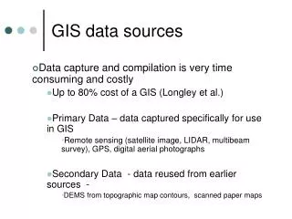
GIS Data and Data Sources DEM, TIGER, DLG, LULC, Soils, DOQQ, DRG. 1. Digital Elevation Models (DEM). The elevation value are stored as a matrix of regularly spaced ground positions Each data point represents the elevation of the grid cell in which it is located. 1. DEM 1:24,000 .

E N D
GIS Data and Data SourcesDEM, TIGER, DLG, LULC, Soils, DOQQ, DRG
1. Digital Elevation Models (DEM) The elevation value are stored as a matrix of regularly spaced ground positions Each data point represents the elevation of the grid cell in which it is located
1. DEM 1:24,000 1:24,000 DEM http://edc.usgs.gov/guides/images/dem/utm.gif - Produced and distributed by USGS - regular grids in UTM coordinates system - 7.5 minute quadrangle coverage - 30 meter by 30 meter resolution - elevation unit is meter - profiles do not always have the same number of elevations - vertical RMS is 7 or 15 meter
1. DEM 1:24,000… The profiles do not always have the same number of elevation points
courtesy: Mary Ruvane, http://ils.unc.edu/ 900 latitude Lines of Latitude (East/West - parallels) Prime Meridian 00 Lines of Longitude (North/South - meridians) Central Parallel 00 Geographic Coordinate System
1. DEM 1:250,000 1:250,000 DEM http://edc.usgs.gov/guides/images/dem/utm2.gif - developed and distributed by USGS - regular grid in geographical coordinates system - 1 degree by 1 degree coverage - 3 arc-second by 3 arc-second resolution - elevation unit is meter - vertical RMS is 15, 30, or 60m
UTM Zones of the World courtesy: http://www.colorado.edu/geography/gcraft/
Difference between Systems UTM and many other coordinate systems are defined based on the geographic coordinate system
1 DEM 1:250,000 DEM… A 10 x 10coverage The spacing along profiles is 3 arc-second
A 2D view of the Onondaga Escarpment that occupies the southern portion of the town of Amherst. The view is looking east with the south to the left of the image.
3D A. Toy, SUNY BUffalo
Bowling Green 3D Display Z=10 J. Yan, SUNY Buffalo
Visibility • 3 scenic lookouts M. Dolce, Buffalo State College
Cave modeling Fisher, Erich , 2005. 3D GIS archaeology in South Africa: archeologists workingalong the South African southern coast use multidimensional GIS applications tomodel Pleistocene caves and paleo-environments reconstructing the landscape CA.420,000 to 30,000 BP. GEO:connexion, 4 (5): 40
Color infrared composite of the IKONOS draped over the DEM as viewed from the west side of the study area to the east from an elevation of 10,000 m, Xichang, ChinaXu, University of Utah, Gong, UC-Berkeley
2. Census Data - TIGER Census units Census tracts - defined by the U.S. Census Bureau for statistical reporting of socio-economic data - their boundaries follow major streets or natural features - each tract comprises a population of approximately 4,000-5,000 - census tracts are numbered consecutively and unique within the jurisdiction
2. Census Data Census units Block groups - comprise a population of approximately 1,000 - boundaries coterminous with tract boundaries Blocks - smallest geographic area formed by street segments - coded by 3 digit numbers, the first one represents the block group, the last two are unique within the block group
2 Census Data… • Census tracts
Proportion of Minorities and TRI Facility Locations Erie County, NY
Census Units County Block Census tract Block group http://www.census.gov/geo/www/tiger/tiger2002/tgr2002.pdf Page 4-17
2. Census Data - TIGER… GBF/DIME Files (for 1970, 1980 census) Geographic Base Files (GBF) - Computerized data files that contain addresses, census tracts, x and y coordinates, political boundaries, etc. Dual Independent Map Encoding system (DIME) - Developed by the Bureau of Census for 1970, 1980 census topologically structured
2. TIGER… Topologically Integrated Geographic Encoding and Referencing (TIGER) Files - developed by the US Census Bureau for 1990 and 2000 census - the spatial and attribute data were combined into one system, and it is topologically structured - combined DIME files and USGS 1:100,000 Digital Line Graph (DLG) files
2. TIGER… - Geographic features: Polygons: geographic area codes (county, city, census tract, block numbers, etc.) Lines: roads, hydrography, railroads, utilities, etc. - Attributes: feature names, address range, etc. - additional attributes: population, housing unit counts, income, occupation, racial distribution, housing values, etc.
2. TIGER… - block level contains aggregated information - All variables are available at the block group level and the tract level
3. Digital Line Graph (DLG) Base cartographic data, distributed by USGS Topographic data - data that portray relief. e.g. DEM Planimetric data - data that include transportation, hydrography, and administrative and political boundaries include spatial data, attribute data, and topology
3. DLG Data Content: 1:24k 1:100k 1:2,000k 7.5'x7.5' 30'x30' multi-state boundaries x x x state, county, city, park hydrography x x x streams and water bodies public land survey system x x xrectangular system transportation x x x roads/trails, railroads, pipelines
3. DLG Data Content: 1:24k 1:100k 1:2,000k 7.5'x7.5' 30'x30' multi-state other man-made struc x ski lift, fences hyposography x x x contour lines veg surface cover x non- veg surface cover x survey control and markers x positions and elevations
4. Land Use Land Cover (LULC) Distributed by USGS 1:250,000 – 10x20, 1:100,000 - 30'x60' Data content Land use and land cover - Anderson classification system level II Political unit - state, county, city boundaries, census tracks, etc. Hydrologic unit - 8 digits HUC, region, subregion, acct. cataloging Federal land ownership
Anderson LULC Classification System • Level I and Level II • 1 Urban or Built-up Land • 11 Residential • 12 Commercial and Services • 13 Industrial • 14 Transportation, Communications, and Utilities • 15 Industrial and Commercial Complexes • 16 Mixed Urban or Built-up Land • 17 Other Urban or Built-up Land • 2 Agricultural Land • 21 Cropland and Pasture • 22 Orchards, Groves, Vineyards, Nurseries, and Ornamental Horticultural areas • 23 Confined Feeding Operations • 24 Other Agricultural Land
Anderson LULC Classification System… • 3 Rangeland • 31 Herbaceous Rangeland • 32 Shrub and Brush Rangeland • 33 Mixed Rangeland • 4 Forest Land • 41 Deciduous Forest Land • 42 Evergreen Forest Land • 43 Mixed Forest Land • 5 Water • 51 Streams and Canals • 52 Lakes • 53 Reservoirs • 54 Bays and Estuaries • 6 Wetland • 61 Forested Wetland • 62 Nonforested Wetland
Anderson LULC Classification System… • 7 Barren Land • 71 Dry Salt Flats. • 72 Beaches • 73 Sandy Areas other than Beaches • 74 Bare Exposed Rock • 75 Strip Mines Quarries, and Gravel Pits • 76 Transitional Areas • 77 Mixed Barren Land • 8 Tundra • 81 Shrub and Brush Tundra • 82 Herbaceous Tundra • 83 Bare Ground Tundra • 84 Wet Tundra • 85 Mixed Tundra • 9 Perennial Snow or Ice • 91 Perennial Snowfield • 92 Glaciers
5. Soils Developed by USDA Natural Resource Conservation Service (NRCS) Soil Survey Geographic Data Base (SSURGO) - 1:24,000, 7.5x7.5 minute quads - based on aerial photographs and field survey - map unit and soil classification: soil series - attributes: physical, chemical, biological, land use
5. Soils State Soil Geographic Data Base (STATSGO) - 1:250,000, 1x2 degree - map unit: soil association - attribute: 60 soil properties - attribute structure - map unit and code - components and their properties - layers and their properties National Soil Geographic Data Base (NATSGO) - 1:7,500,000
STATSGO Attributes A set of relational tables is used to store the attributes for the Map Unit and its Components http://www.ncgc.nrcs.usda.gov/products/datasets/statsgo/data/ny.html
6. Digital Orthophoto Quarter Quad (DOQQ) Developed by USGS and state and local governments Digital aerial photographs without geometric errors introduced by tilt or relief displacement
7. Digital Raster Graphics Developed by USGS A raster image of a scanned USGS topographic map georeferenced to the UTM grid Useful as a background layer in a GIS, or to be merged with other digital data to produce a hybrid digital file
http://en.wikipedia.org/wiki/Digital_raster_graphic http://topomaps.usgs.gov/drg/