Download
1 / 21
220 likes | 368 Vues
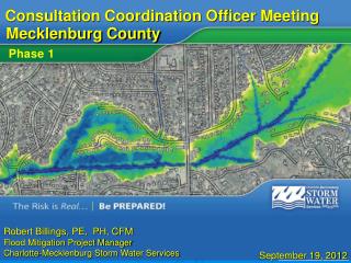
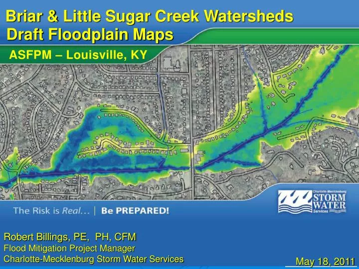
Briar & Little Sugar Creek Watersheds. Draft Floodplain Maps. ASFPM – Louisville, KY. Robert Billings, PE, PH, CFM Flood Mitigation Project Manager Charlotte-Mecklenburg Storm Water Services. May 18, 2011. Mecklenburg County North Carolina. Land Area: 549 square miles.

E N D
Briar & Little Sugar Creek Watersheds Draft Floodplain Maps ASFPM – Louisville, KY Robert Billings, PE, PH, CFM Flood Mitigation Project Manager Charlotte-Mecklenburg Storm Water Services May 18, 2011
Mecklenburg County North Carolina Land Area: 549 square miles Mecklenburg County includes the City of Charlotte and the towns of Cornelius, Davidson, Huntersville, Matthews, Mint Hill, and Pineville (8 NFIP Communities)
Local Flood Mapping • Current maps are result of County-wide FIS completed in February 4, 2004 at a cost of $2,000,000 • 350 miles of detailed study streams • 32 watersheds • FEMA and Community flood fringe and floodway • Data reproduced in state-wide format effective March 2, 2009 • 182 panels, paper and digital forms • Remapping began in 2007 on two basins , expanded in 2008 to include the majority of the remainder of the county
Public Meetings Using Technology to Involve the Public in the Remapping Process • Charlotte-Mecklenburg and draft flood map meetings • New Technology • A different approach to public meetings
Meeting Purpose • Gather public input on draft Floodplain Maps • Show new Risk Communication Products • Show how information can be used • Increase understanding of flood risk “Sandwich Approach” Public Input Land Use Task Force Draft Floodplain Mapping Open House Flood Insurance Rate Maps (Compliance Period)
Why Floodplain Maps Change Flood Risk Changes Over Time Climatological Changes Natural & Man Made Land Changes Technological Advancements • Better Data • Improved computer models • Enhanced Map Products • Extended Historic Rainfall Records • Changes in Rain Intensity, Duration, Frequency, etc. • Natural Geomorphic Stream Changes • Development within the Watershed
Floodplain Mapping History • Protecting Life and Property • Community Sustainability & Resiliency • Communicate& Reduce Flood Risk Why are “Floodplains” Mapped? Uses for Flood Risk Information • Flood Insurance • Regulate New Development • Flood Preparedness • Planning • Mitigation • And more…..
Floodplain Mapping History Current Maps 2004, 2009 1% annual chance Flood First Maps Dated 1978 – 20041% annual chance Flood Current Maps available online with additional property information
Using New Flood Map Products • Knowing your flood risk is the first step intaking actions toward Reducing your risk.
Online Flood Map Review • http://mapserver.mecklenburgcountync.gov/fmr/ • Public Review & Comment Period closesNovember 16th
Public Meetings Three Public Meetings were organized during September and October of 2010 • The website address of the FMR application was published prior to the meetings • The meetings began with a brief introduction and floodplain 101 presentation • After the introduction, the attendees were asked to find a staff member or open laptop station to view the new floodplain data
On-Line Survey Results Meeting attendees were asked to complete a brief online survey related to the mailers, meetings and FMR application • One-on-one sessions with laptops and Storm Water Services staff were helpful to me. 60% Strongly Agree • I would have preferred a traditional meeting with one formal presentation. 80% Disagree • Not including the public meeting, I have looked at the draft floodplain maps online. 90% Yes
Tim Trautman, PE, CFM Flood Mitigation Program Manager (704) 336-7357 Tim.Trautman@ MecklenburgCountyNC.gov Robert Billings, PE, PH, CFM Floodplain Mapping Project Manager (704) 432-0907 Robert.Billings@ MecklenburgCountyNC.gov Thank You